Consistently Inconsistent: April 2022 Recap
New Jersey State Climatologist
Center for Environmental Prediction, School of Environmental and Biological Sciences/NJAES
Rutgers University
May 7, 2022
Overview
As has been the case for the past several months, weather patterns have been reluctant to persist for more than several days to about a week. While climatologically rather common as winter transitions to summer, this season has seemingly been consistently inconsistent beyond the norm. April saw temperatures reach well into the 80°s on several days, followed a short time later by a hard freeze in most inland locations. Rainfall was above normal, more than twice so in the northwest, which is a reversal of the general pattern since late fall. Precipitation fell every few days, including multiple squally episodes that briefly delivered small hail, graupel, and bursts of snow at some locations. There was one event that brought some flash flooding and minor river flooding. Many residents are impatiently waiting for some mild conditions to lock in, getting summer underway. Patience….summer will arrive!
The good news is the rainfall that arrived quite often. Increasing concerns for drought encroaching on NJ were washed away by multiple storms that “performed” up to or exceeded expectations, something that was often not the case for multiple underperforming events in past months. Statewide rainfall averaged 5.10”. This is 1.40” above the 1991–2020 normal and ranks as the 24th wettest April since records commenced in 1895. As the monthly map shows (Figure 1), the northwest was wettest and south driest, yet still above normal. The north average 6.34” (+2.44”, 11th wettest), south 4.37” (+0.79”, 32nd wettest), and coast 4.09” (+0.54”, 42nd wettest).
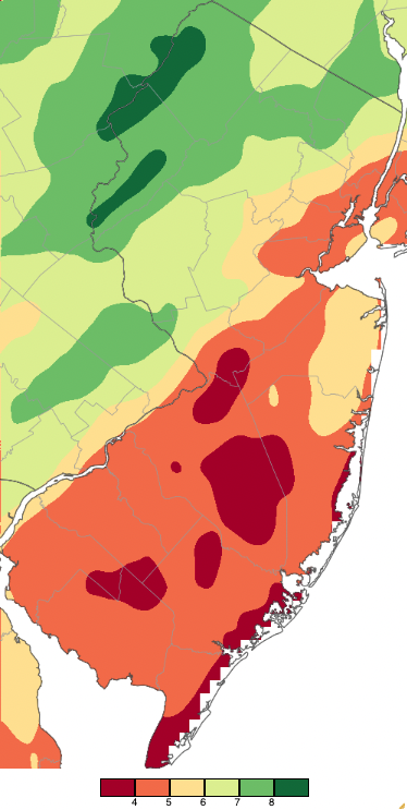
Figure 1. April 2022 precipitation across New Jersey based on a PRISM (Oregon State University) analysis generated using NWS Cooperative and CoCoRaHS observations from 7AM on March 31st to 7AM on April 30th (PM rainfall on March 31st is included in April totals). Note the scale in full inches at the bottom of the map. Totals range from 3.00–4.00” (dark red) to 8.00”–9.00” (dark green).
As a result of the abundant rain, by mid-month the U.S. Drought Monitor no longer considered all of the state as being “abnormally dry” or in “moderate drought” (southern quarter), later reducing the rating to abnormally dry in what had been the moderately dry region, and by month’s end abnormally dry only in the far southeast. The frequent precipitation also kept wildfire danger low at what is often its peak time of the year.
Statewide snowfall amounted to a trace, which is 0.8” below normal. The northern snowfall division averaged 0.1”.
Temperatures averaged slightly below normal in April. The statewide mean temperature of 51.0° was 0.5° below normal, ranking 41st warmest of the past 128 years. This seeming incongruity between departure and ranking is due to the 1991–2020 normal interval being considerably milder than the average over the full ranking period. The average maximum temperature was 61.5° (-1.2°, 50th warmest) and the minimum averaged 40.4° (+0.1°, 32nd warmest). The north climate division averaged 49.2° (-0.7°, 49th warmest), south 52.0° (-0.6°, 41st warmest), and coastal 51.6° (-0.1°, 32nd warmest).
Precipitation and Storms
Six NJ CoCoRaHS stations received over 8.00” of precipitation in April. Leading the way was Stillwater (Sussex County) with 8.49”, followed by Oxford Township (Warren) 8.42”, Wayne (Passaic) 8.27”, Montague (Sussex) 8.18”, White Township (Warren) 8.17”, and Hackettstown (Warren) 8.01”. Far south and west central areas came in on the low end, with Sea Isle City (Cape May) catching just 2.74”, Hamilton (Mercer) 3.36”, Lower Township (Cape May) 3.56”, Medford Township (Burlington) 3.59”, and Mansfield (Burlington) 3.61”. There were just four CoCoRaHS stations reporting measurable snow for the month, namely Randolph Township (Morris) with 0.2”, and 0.1” at Mount Olive (Morris), Rockaway Township (Morris), and Greenwich Township (Warren).
The first event of the month actually began during the evening of March 31st, persisting into the afternoon of April 1st. Heaviest totals were in the northwest corner of the state, with Oxford receiving 2.21”, Mount Olive 1.96”, and Hackettstown 1.86” (Figure 2). Of 253 CoCoRaHS stations reporting, 45 caught 1.00”–2.41” and 89 from 0.50”–0.99”. Monmouth and Burlington counties southward received less than 0.50”. Rice to pea-size hail was observed at several Morris County locations. Strong winds accompanied this event and its aftermath, including High Point Monument (HPM; Sussex) having a gust of 52 mph, Pennsauken (Camden) 49 mph, and 16 Rutgers NJ Weather Network stations gusting from 40–47 mph on the 1st. HPM reached 50 mph on the 2nd.
The 3rd brought precipitation back to NJ in the form of rain in most locations, while morning snow accumulated at elevations around 1400 feet in the northwest, with over an inch seen at High Point State Park (Sussex; Figure 2). Some evening thunderstorms contained rice to pea-size hail in Warren and Ocean counties. The only stations with more than 0.50” of liquid precipitation were Neptune (Monmouth) with 0.60” and Flemington (Hunterdon) at 0.57”. Winds gusted to 43 mph at Lower Alloways Creek Township (Salem) and 41 mph in Fortescue (Cumberland) and Little Egg Harbor Township (Ocean) on the 3rd, and 40 mph at HPM on the 4th.
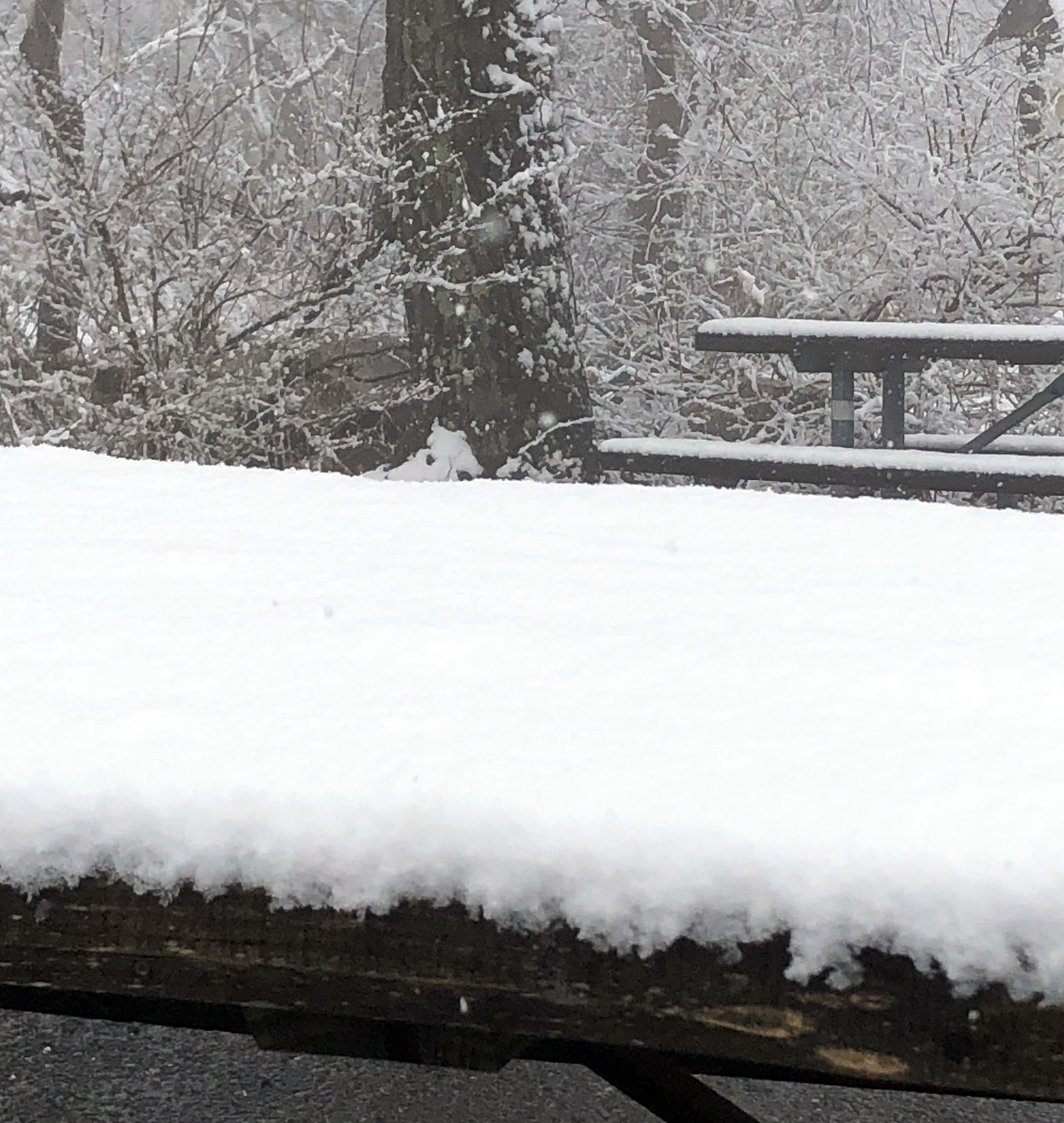
Figure 2. Fresh snowfall at High Point State Park on April 3rd. Photo courtesy of Anthony Glentz.
Rain moved into the state from south to north on the evening of the 5th and was out of the area by midday on the 6th. This time, the south caught the most precipitation, with totals tapering to the north until NJ/NY border areas came in under 0.50” (Figure 3). Linwood (Atlantic) saw the most with 2.94”, followed by 2.80”, 2.68”, and 2.61” totals at three Woodbine (Cape May) locations, Ocean City (Cape May) 2.63”, and Dennis Township (Cape May) 2.61”. 17 CoCoRaHS sites caught from 2.00”–2.94” and 102 from 1.00”–1.99”. Atlantic City Marina (Atlantic) had a 50-mph gust on the 6th.
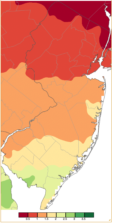
Figure 3. Precipitation across New Jersey from 7AM on April 5th through 7AM April 7th based on a PRISM (Oregon State University) analysis generated using generated using NWS Cooperative and CoCoRaHS observations. Note the scale in inches beneath the map.
Quickly on the heels of the previous event came the biggest rainmaker of the month, and the largest since October of last year for the northern half of NJ (Figure 4). Some flash flooding and minor river flooding resulted from rain that began falling during the morning of the 7th, becoming heavy in evening thunderstorms, before diminishing before daybreak on the 8th. Totals were as large as 4.14” in Wayne, Paterson (Passaic) 4.11”, Glen Rock (Bergen) 4.05”, Hawthorne (Passaic) 3.92”, and Denville (Morris) 3.85”. Of 256 CoCoRaHS reports, 37 were from 3.00”–4.14”, 68 from 2.00”–2.99”, and 48 from 1.00”–1.99”. HPM gusted to 43 mph on the 7th.
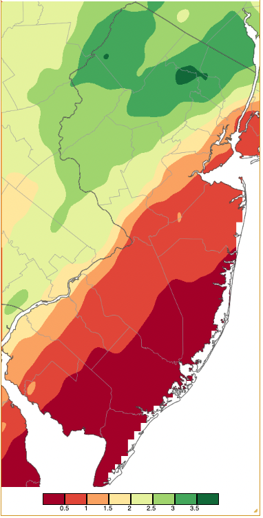
Figure 4. Precipitation across New Jersey from 7AM on April 7th through 7AM April 8th based on a PRISM (Oregon State University) analysis generated using generated using NWS Cooperative and CoCoRaHS observations. Note the scale in inches beneath the map.
Rain on the 9th fell early and then evolved into squally showers in the afternoon and evening, some including graupel and pea-size hail in northern and central areas. Mount Olive caught 0.74”, Franklin (Sussex) 0.71”, and Vernon Township (Sussex) 0.67”. Gusty conditions followed on the 10th with HPM up to 44 mph, Little Egg Harbor Township 42 mph, and Harvey Cedars (Ocean) 40 mph. They accompanied more squalls that again brought graupel and rice-size hail to parts of northern NJ.
Scattered thunderstorms during the late afternoon and early evening of the 14th delivered 0.83” to South Brunswick (Middlesex), 0.72” at North Brunswick (Middlesex), and 0.70” in both East Brunswick (Middlesex) and Franklin Township (Somerset). HPM and Pennsauken both gusted to 51 mph on the 14th, with seven stations from 40–49 mph. A possible microburst did some structural damage in Bergenfield (Bergen). Two locations catching over 0.50” of rain from the evening of the 16th into early on the 17th were Weymouth Township (Atlantic) with 0.60” and Galloway Township (Atlantic) 0.50”. Quarter-size hail was observed in Burlington County and pea-size hail seen in Cumberland County. Winds gusted to 45 mph at HPM on both the 16th and 17th.
The eighth system of the month to deliver 0.50” or more rain somewhere in NJ arrived during the evening of the 18th, ending in the predawn hours of the 19th. This was a widespread uniform soaking that brought as much as 2.98” to Red Bank (Monmouth) and, on the low end, 0.73” to East Windsor (Mercer; Figure 5). Additional large totals included Howell (Monmouth) 2.79”, Toms River (Ocean) 2.74”, and Union Beach (Monmouth) 2.70”. Out of 254 CoCoRaHS reports, 24 were between 2.00”–2.98” and 222 from 1.00”–1.99”. Strong winds blew across NJ on the 18th and 19th, on the first day reaching 65 mph at Atlantic City Marina, Little Egg Harbor Township 54 mph, Harvey Cedars 50 mph, and 40–49 mph at six locations. The 19th brought gusts to 52 mph at Little Egg Harbor Township, Fortescue 49 mph, and 11 sites from 40–48 mph.
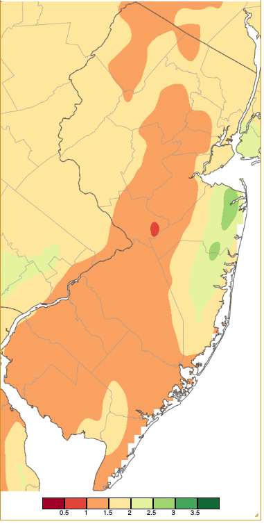
Figure 5. Precipitation across New Jersey from 7AM on April 18th through 7AM April 20th based on a PRISM (Oregon State University) analysis generated using generated using NWS Cooperative and CoCoRaHS observations. Note the scale in inches beneath the map.
The highest barometric pressure of the month ranged from 30.45”–30.55” on the 21st, with the 20th a close runner up at 30.45”–30.50”. The 1st saw the lowest pressure at 29.40”–29.50”, followed closely by 29.45”–29.55” on both the 7th and 8th. Aside from the days with 40 mph or greater gusts mentioned previously, gusts on the 27th reached 45 mph at HPM, 44 mph in Lower Alloways Creek Township, and 40 mph at both Fortescue and Sea Girt. The 28th saw a gust to 53 mph at HPM with five stations gusting from 40–44 mph. HPM achieved a 41-mph gust on the 29th.
Temperature
Nine April days saw some NJWxNet stations with maximum temperatures exceeding 70°. This is only two days more than the number of 70° plus days in March. The first of those days was the 12th when Sicklerville (Camden) and Woodbine each reached 76° and 51 of the 64 NJWxNet stations were from 70°–75°. This began the longest run of warm April conditions, continuing on the 13th when highs leaped up to 86° in Sicklerville, 85° at West Deptford (Gloucester), 80°–84° at 29 locations, and 70°–79° at 23 others. A sea breeze off the still cold Atlantic waters kept Harvey Cedars on Long Beach Island with a 61° high. At 2:15 PM on the 13th, statewide temperatures ranged from 55° at Harvey Cedars to 85° at Sicklerville, just 45 miles apart (Figure 6).
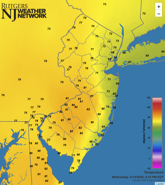
Figure 6. Temperatures across NJ and nearby states at 2:15 PM on April 13th. Observations are from NJWxNet, National Weather Service, and Delaware Environmental Observing System stations.
The mid-month warm spell peaked on the 14th, with Toms River and Newark Airport (located in Elizabeth; Union) up to 88° (a record at the airport). Berkeley Township (Ocean) and Sicklerville reached 87°, 23 stations were 85°–86°, 27 from 80°–84°, 8 from 70°–79°, and three either 66° (Fortescue) or 67° (Figure 7). The 15th cooled to maximums of 72° at Sicklerville and 70°–71° at 20 other NJWxNet stations. Sicklerville reached 79° on the 16th, followed by Moorestown (Burlington) and West Deptford each at 78° and 46 stations from 70°–77°.
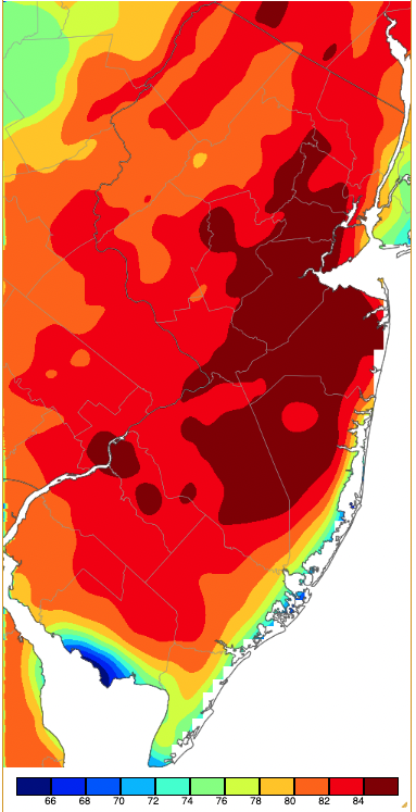
Figure 7. Maximum temperatures on April 14th based on a PRISM (Oregon State University) analysis generated using NWS, NJWxNet, and other professional weather stations. Note the 2-degree increment scale beneath the map.
Warmth returned on the 22nd when Woodbine reached 75° and 39 stations peaked from 70°–74°. West Deptford was 75° on the 24th, with 13 sites from 70°–74°, but highs of just 55° occurred at Seaside Heights (Ocean) and Harvey Cedars. Woodbine reached 79° on the 26th, with Oswego Lake (Burlington) 77° and 26 stations from 70°–76°. At northern high elevations, Vernon Township only managed a 54° high and HPM 55°. Hamilton (Mercer) hit 71° and Mansfield 70° on the 30th.
There were two five-day April runs of low temperatures at or below the freezing point at one or more NJWxNet stations, along with four-day and two-day runs. HPM started off the first run on the 1st with a 32° low. The 2nd found HPM at 28°, and High Point (Sussex) and Vernon Township each 30°. Winds calmed some and the cold shifted to the valley locations of Sandyston (Sussex) and Walpack (Sussex) which, along with HPM, fell to 31° on the 3rd. Berkeley Township in the Pinelands fell to 28° on the 4th with nine other NJWxNet locations from 30°–32°. Sandyston, Walpack, and Hopewell Township (Mercer) reached 28° with 12 stations from 29°–32° on the 5th.
Freezes returned on the 10th with HPM at 30° and High Point 32°. Sandyston fell to 26° on the 11th with 16 sites from 27°–32°. The next five-day run began on the 17th when Walpack hit 27°, Pequest (Warren) and Sandyston 28°, and 14 stations from 29°–32°. The coldest day of the month was the 18th when Berkeley Township fell to a statewide monthly low of 21°, Walpack and Pequest 22°, Sandyston 23°, and 44 other NJWxNet stations from 24°–32° (Figure 8). Only urban and coastal locations remained above freezing, with Harvey Cedars and Seaside Heights (just 12 miles from Berkeley Township) mildest at 42°.
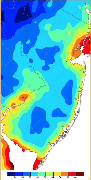
Figure 8. Minimum temperatures on April 18th based on a PRISM (Oregon State University) analysis generated using NWS, NJWxNet, and other professional weather stations. Note the in 2-degree increment scale beneath the map.
Vernon Township dropped to 29° on the 19th, with three locations from 31°–32°. Berkeley Township was the lone freezing spot at 32° on the 20th. Berkeley Township and Walpack shared low honors at 29° on the 21st when seven sites were from 30°–32°, with Fortescue mildest at 49°.
An unusual run of four subfreezing nights ended the month (May 1st also saw some freezing minimums). HPM and Vernon Township fell to 31° on the 27th, with Vernon Township at 27° and four sites from 30°–32° on the 28th. Walpack took low honors at 22° on the 29th, followed by Pequest at 23° and 18 NJWxNet sites from 27°–32°. Walpack was again coldest with 24° on the 30th when Pequest hit 25°, Berkeley Township 26°, and 20 locations from 27°–32°.
For those seeking more detailed information on 5-minute, hourly, daily, and monthly conditions, please visit the following Office of the NJ State Climatologist's websites:
Rutgers NJ Weather Network
NJ Community Collaborative Rain, Hail and Snow Network
NJ Snow Event Reports
Interested in receiving our monthly summaries at the end of each month? Send us your e-mail address here to join the mailing list.
Past News Stories

