Lost Winter: February 2024 & Winter 2023/2024 Recaps
New Jersey State Climatologist
Center for Environmental Prediction, School of Environmental and Biological Sciences/NJAES
Rutgers University
March 7, 2024
February Overview
Perhaps the title of this report is a bit overstated when it comes to February weather conditions, but not by all that much. However, like much of the coterminous United States, it applies rather appropriately to the December 2023–February 2024 winter. New Jersey’s winter conditions follow at the end of this report, with February discussed first.
February 2024 was on the dry side. In fact, the statewide average precipitation (rain and melted snow) of 1.55” was 1.31” below the 1991–2020 normal and ranks as the 12th driest since records began in 1895 (Figure 1). The northern climate division averaged 1.68” (-1.11”, 12th driest), the southern division 1.47” (-1.42”, 10th driest), and the coastal division 1.44” (-1.63”, 7th driest).
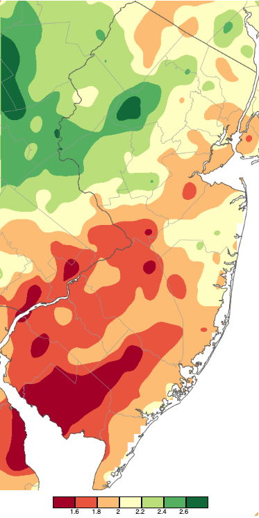
Figure 1. February 2024 precipitation across New Jersey based on a PRISM (Oregon State University) analysis generated using NWS Cooperative and CoCoRaHS observations from 7 AM on January 31st to 7 AM on February 29th. Note the scale in inches at the bottom of the map. Totals range from 1.40”–1.60” (dark red) to 2.60”–2.80” (dark green).
February snowfall averaged 7.9” across NJ. This was just 0.3” below normal, ranking as the 51st snowiest since 1895. The North snow division averaged 12.4” (+2.1", 40th snowiest), Central 12.4" (+3.3", 36th snowiest), and South 3.2" (-3.5", 58th least snowy). The vast majority of the snow fell in two events four days apart, with mild temperatures that soon followed prohibiting the snow cover for sticking around for too long.
In fact, mild days outnumbered cold ones during February, leading to a monthly statewide average of 37.0°, which was 3.1° above normal and ranks as the 14th mildest on record. The statewide average daily high temperature of 46.3° was 3.2° above normal and ranks 16th mildest. The daily minimum of 27.8° was 3.2° above normal, ranking 9th mildest. The north averaged 34.9° (+3.6°, 12th mildest), south 38.3° (+2.8°, 16th mildest), and coast 38.4° (+2.4°, 16th mildest).
Precipitation and Storms
There were just two storm events worthy of considerable note in a generally tranquil month. Together, these and a few modest events led to individual station totals as high as 2.74” at Mine Hill Township (Morris County), Holland Township (Hunterdon) 2.73”, Jefferson Township (Morris) 2.53”, Mount Olive Township (Morris) 2.49”, and Bernardsville (Somerset) 2.47”. On the low end, down south, both Buena Vista (Atlantic) and Winslow Township (Camden) caught 1.37”, Woodstown (Salem) 1.47”, Upper Deerfield (Cumberland) 1.50”, and Pitman (Gloucester) 1.57”.
Individual station snowfall totals were associated with the two largest storms. Together, the highest totals were recorded in Hunterdon County, including 21.6” in Franklin Township, Frenchtown 21.3”, Flemington 19.2” and Lebanon Township 17.5”. Branchburg (Somerset) was also among the top five totals at 18.3”. On the low end, Lower Township (Cape May) saw just 1.0”, Estell Manor (Atlantic) 1.5”, Ocean City (Cape May) and Pine Beach (Ocean) each with 1.6”, and both Woodbine (Cape May) and Point Pleasant Beach (Ocean) 2.0”.
The first minor period of rain occurred early on the 2nd with 0.36” at Ocean Township (Monmouth County) and 0.35” in both Livingston (Essex) and Brick Township (Ocean). This ended a 12-day siege of cloud cover over the state, setting the stage for clearing early on the 3rd, with skies mostly clear for five days.
On the 12th, rain spread during the PM hours from south to north, quickly becoming snow in the north and eventually transitioning to sleet and then snow during the pre-dawn hours of the 13th in central NJ. Southern areas briefly saw a change to snow toward the midday end of the storm. Rain and melted snow accumulated to 1.26” in Andover Township (Sussex), Flemington 1.22”, and 1.19” in both Franklin Township (Hunterdon) and Frelinghuysen Township (Warren). Of 227 CoCoRaHS reports, 37 were between 1.00”–1.26” and 182 from 0.50”–0.99”, with some locations in the southeast receiving less (Figure 2).
Snowfall amounted to 2.0” or more in 14 northern and central counties (Figure 3, Table 1). Thirteen of the counties had a station receiving at least 5.1”. Montague (Sussex) took top honors with 13.1” and 14 of the 17 reports from Sussex County topped 10.0”. A February 14th visible satellite image shows the north snow covered and the south with snow-free conditions (Figure 4).
Winds were strong in coastal areas on the 13th, transitioning to windy mountaintops on the 14th. The former day saw gusts to 45 mph at Little Egg Harbor Township (Ocean), with Atlantic City Marina (Atlantic), Sea Girt (Monmouth), and Seaside Heights (Ocean) all at 44 mph, and Lower Alloways Township (Salem) 43 mph. Vernon Township (Sussex) and High Point Monument (Sussex) topped out at 47 mph and 46 mph, respectively, on the 14th.
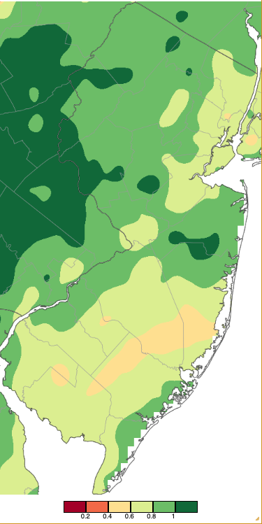
Figure 2. Precipitation across New Jersey from 7 AM on February 12th through 7 AM February 14th based on a PRISM (Oregon State University) analysis generated using NWS Cooperative and CoCoRaHS observations. Note the scale in inches beneath the map.
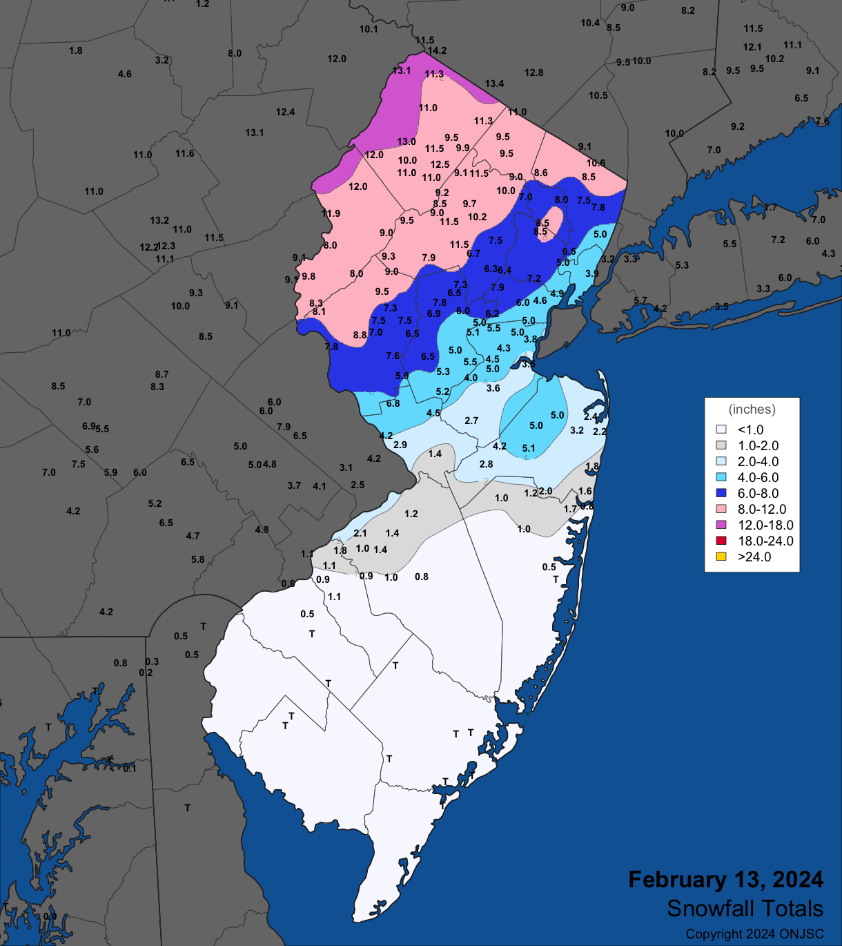
Figure 3. Snowfall on February 13th. Observations are from CoCoRaHS, NWS Cooperative Observer, NWS Trained Spotter, and reports from the North Jersey Weather Observers.
| County | Location | Snowfall |
| Bergen | Montvale | 10.6” |
| Burlington | Delran | 2.1” |
| Essex | Montclair | 8.7” |
| Hudson | Harrison | 5.5” |
| Hunterdon | Clinton | 9.5” |
| Mercer | Woodville | 6.8” |
| Middlesex | South Plainfield | 5.5” |
| Monmouth | Freehold | 5.1” |
| Morris | Green Pond, Randolph, Mine Hill | 11.5” |
| Passaic | West Milford | 9.5” |
| Somerset | Watchung | 8.5” |
| Sussex | Montague | 13.1” |
| Union | New Providence | 7.9” |
| Warren | Blairstown | 12.0” |
Table 1. Maximum snowfall for the February 13th storm in all NJ counties where at least one location reported 2.0” or more. Observations are from CoCoRaHS, NWS Cooperative Observer, NWS Trained Spotter, and reports from the North Jersey Weather Observers.
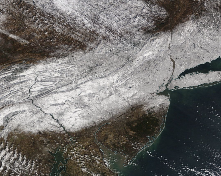
Figure 4. NASA MODIS visible satellite image on the morning of February 14th showing snow cover over New Jersey and surroundings north of approximately Interstate 195. The dark spot in west central NJ is unfrozen Round Valley Reservoir (Hunterdon). NJ skies are cloud-free except some scattered clouds in the far south. Clouds are located just to the northwest of Sussex County in Pennsylvania and New York.
Next up was an all-snow event beginning late on the 16th and ending during the morning of the 17th. It was difficult to forecast and proved to be rather unusual. Frontogenesis (the creation and strengthening of a horizontal temperature gradient) result in a concentrated 20-mile-wide band of heavy snow across central counties, leaving the rest of the state with under 4.0” (Figure 5). Most every location in every NJ county caught 2.0” or more, though only eight had towns with at least 5.0” (Table 2). Of those counties with 10.0” or more, Hunterdon County had Frenchtown receive 13.5”, Warren had Riegelsville with 10.7”, Somerset with 11.5” in Branchburg, and Middlesex with 11.3” in New Brunswick. The bulk of the deep snow fell in just several hours after midnight and well before dawn.
Another oddity of this storm was the exceedingly low water content of the snow, particularly where the deepest snow fell. The highest liquid equivalent in the state was 0.50” at Hopewell Township (Mercer), followed by 0.46” in Woodbridge (Middlesex) (Figure 6). Thus, the ratio of snow depth to liquid precipitation depth was in the 20:1 to 25:1 range when it is rare to see a notable snow event with ratios exceeding 15:1. This high ratio was due to quite cold air aloft, despite surface air temperatures hovering near the freezing point. The distribution of the liquid equivalent strikingly displays the fact that the rising motion along the band of the heaviest snow led to a response of descending air and lower precipitation totals in bands 20 miles or so to the south and over north Jersey (the latter in part due to the overall storm not making it that far north).
Winds associated with the storm on the 16th gusted to 56 mph in Vernon Township, 48 mph at High Point Monument and Wantage (Sussex), and 40–45 mph at four other NJWxNet stations. On the 17th, Fortescue (Cumberland) had a gust of 40 mph and Vernon Township was up to 41 mph on the 18th.
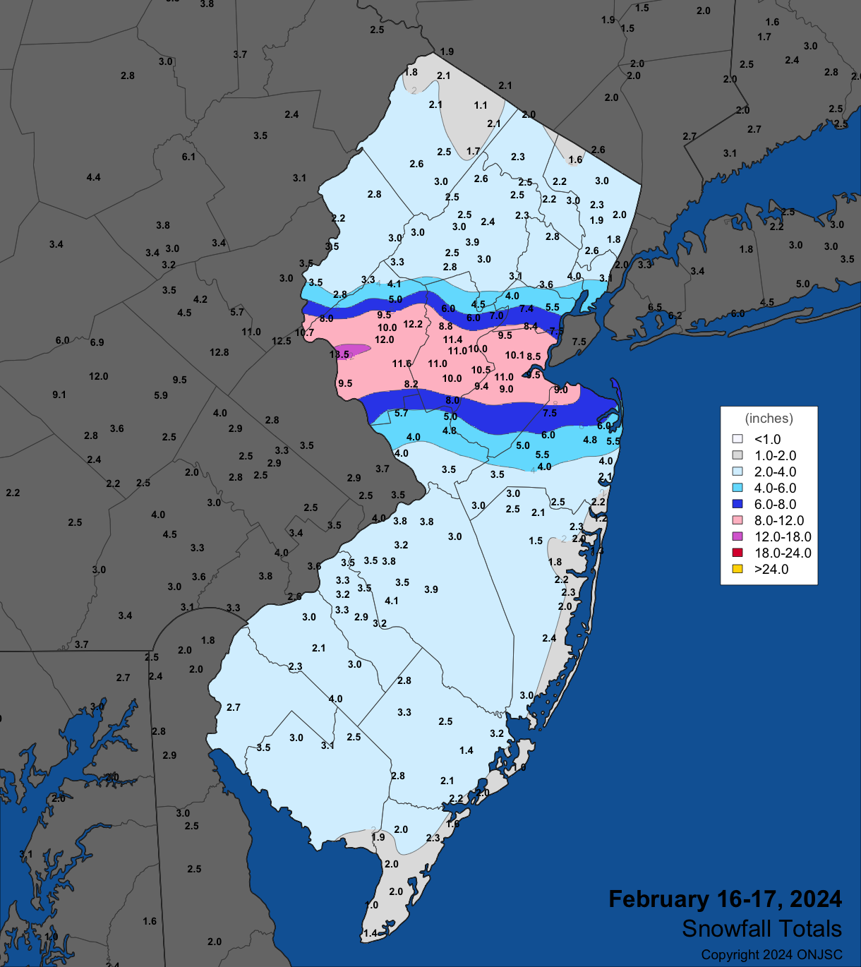
Figure 5. Snowfall on February 16th–17th. Observations are from CoCoRaHS, NWS Cooperative Observer, NWS Trained Spotter, and reports from the North Jersey Weather Observers.
| County | Location | Snowfall |
| Atlantic | Hammonton | 3.5” |
| Bergen | Hillsdale, North Arlington, Westwood | 3.0” |
| Burlington | Lake Pine | 4.1” |
| Camden | Pennsauken | 3.5” |
| Cape May | Seaville | 2.3” |
| Cumberland | Stow Creek | 3.5” |
| Essex | Maplewood | 3.6” |
| Gloucester | Franklin Township | 4.0” |
| Hudson | Jersey City | 4.3” |
| Hunterdon | Frenchtown | 13.5” |
| Mercer | Woodsville | 5.7” |
| Middlesex | New Brunswick | 11.3” |
| Monmouth | Keyport, Union Beach | 9.0” |
| Morris | Long Hill Township | 4.5” |
| Ocean | Jackson Township, Tuckerton | 3.0” |
| Passaic | Hawthorne | 3.0” |
| Salem | Pittsgrove | 3.0” |
| Somerset | Branchburg | 11.5” |
| Sussex | Sparta | 4.0” |
| Union | Clark | 8.4” |
| Warren | Riegelsville | 10.7” |
Table 2. Maximum snowfall for the February 16th–17th storm in all NJ counties. Observations are from CoCoRaHS, NWS Cooperative Observer, NWS Trained Spotter, and reports from the North Jersey Weather Observers.
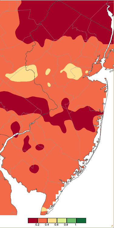
Figure 6. Precipitation across New Jersey from 7 AM on February 16th through 7 AM February 18th based on a PRISM (Oregon State University) analysis generated using NWS Cooperative and CoCoRaHS observations. Note the scale in inches beneath the map is the same as in Figure 2.
The late afternoon and evening of the 27th found rain in the north, most of which tapered off by dawn of the 28th. Mount Olive Township received 0.85” and 0.71” (two locations), Oxford Township (Warren) 0.69”, and 33 of the 240 CoCoRaHS reports came in with 0.50”–0.68”.
Afternoon rain on the 28th became squally during the evening as a strong cold front moved through the state. Pittsgrove Township (Salem) received 0.58”, Clinton (Hunterdon) 0.53”, and Upper Deerfield 0.50”. The most notable aspect of this event was the gusty wind that evening and into the 29th. On the 28th, gusts reached 56 mph at High Point Monument, Lower Alloways Creek Township (Salem) 55 mph, Fortescue 54 mph, both Vernon Township and Pennsauken (Camden) 51 mph, and Sea Girt 50 mph. Another 24 NJWxNet stations gusted from 40–49 mph. Gust on the 29th included 57 mph at Vernon Township, 50 mph at both Little Egg Harbor Township (Ocean) and Seaside Heights, and 40–48 mph at ten other NJWxNet locations.
The lowest barometric pressures of the month occurred on the 13th and 23rd, ranging from 29.35”–29.50”. Pressures rose to a monthly high of 30.50”–30.55” on the 20th. Only the aforementioned seven days had at least one NJWxNet station gusting to 40 mph.
Temperature
In this relatively mild second month of 2024, the daily high temperature at one or more NJWxNet stations exceeded freezing each day. However, there was not a day when at least one station didn’t have a low below freezing and there were seven days where all 67 stations had subfreezing lows. On 15 days, a station dropped to 20° or colder, with 10 of those days 15° or colder. The first of these was the 6th with Walpack (Sussex) down to 14°, then this station fell to 15° on the 7th. A long run of cold lows began on the 15th with Walpack at 8° and nine stations from 10°–15°. Walpack reached 11° on the 17th with six stations from 13°–15°. The 18th was the coldest morning of the month with Walpack at 4°, six locations from 7°–10°, nine from 11°–15°, and 24 from 16°–20° (Figure 7). Urban and coastal stations only dipped to the 20°s with Fortescue mildest at 31°. Kingwood (Hunterdon) was coldest at 12° on the 19th with Walpack trailing at 14°. It was yet again Walpack coldest on the 20th at 6°, Sandyston (Sussex) at 8°, Kingwood 9°, and seven sites from 11°–15°. The 21st found Walpack at 7° and nine sites from 10°–15°, while Harvey Cedars (Ocean) remained above freezing at 33°. Rather than cold air settling into snow-covered valleys, advection of cold air from the north arrived on the 24th to drop the low to 14° at High Point Monument. Again, on the 25th, the Monument station took low honors at 9° with ten stations from 11°–15°.
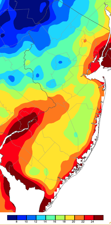
Figure 7. Minimum temperatures on February 18th based on a PRISM (Oregon State University) analysis generated using NWS, NJWxNet, and other professional weather stations. Note the 2° scale beneath the map.
Thirteen February afternoons found high temperatures of 50° or higher at multiple NJWxNet stations, with six of those days at 55° or higher. The first trio of 55°-plus days began on the 8th with nine locations up to 56° and 15 stations 55°. Five stations reached 62° on the 9th, with 14 either 60° or 61° and 31 from 55°–59°. Egg Harbor Township, Haworth (Bergen), and Mullica (Atlantic) hit 61° on the 10th, with five sites at 60° and 53 from 55°–59°, while High Point Monument was coolest at 52°.
It took until the 26th to again reach the 55° threshold, with five stations up to 62°, 12 either 60° or 61°, and 36 from 55°–59°, while Harvey Cedars was coolest at 47°. The 27th was the warmest of February 2024. A high of 69° was reached at a quartet of NJWxNet stations, including Cream Ridge (Monmouth), Fort Dix (Burlington), Hammonton (Atlantic), and Red Lion (Burlington). Twenty-three other stations reached from 65°–68°, 16 from 60°–64°, and 13 from 55°–59°. The coolest spots were at the coast, including 51° at Atlantic City Marina, West Cape May (Cape May), and Harvey Cedars. Hopewell Township rose from a morning low of 27° to a maximum of 67°, a notable 40° diurnal range that was the highest in the state. The 28th found Vineland (Cumberland) up to 66°, Hammonton, Mannington (Salem), and Piney Hollow (Gloucester) all at 65°, 37 stations from 60°–64°, 24 from 55°–59°, and High Point Monument coolest at 52°.
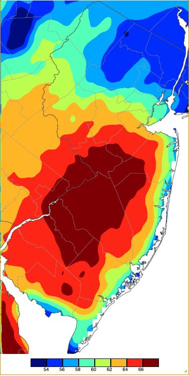
Figure 8. Maximum temperatures on February 27th based on a PRISM (Oregon State University) analysis generated using NWS, NJWxNet, and other professional weather stations.
Winter Overview
The winter of 2023/2024 (December–February) ranked in the top 10 for mildest temperatures and most precipitation (rain and melted snow). The 37.5° average was 3.5° below normal and ranked 9th mildest. Nine of the ten mildest winters of the past 135 have occurred since 1997/98, with five in the past eight years (Table 3). This was only the second winter this century to place in the top 10 for precipitation, with five ranking high before the middle of the 20th century (Table 4).
| Rank | Year | Winter Avg. Temp. |
| 1 | 2001/02 | 38.8° |
| 2 | 2022/23 | 38.6° |
| 3 | 2015/16 | 38.5° |
| 4 | 2011/12 | 38.3° |
| 5 | 1997/98 | 38.0° |
| 6 | 1931/32 | 37.9° |
| 7 | 2016/17 | 37.6° |
| 7 | 2019/20 | 37.6° |
| 9 | 2023/24 | 37.5° |
| 10 | 1998/99 | 36.2° |
Table 3. The 10 mildest winters across NJ since 1895/96.
| Rank | Year | Winter Avg. Precip. |
| 1 | 1978/79 | 19.17” |
| 2 | 1914/15 | 17.66” |
| 3 | 1901/02 | 16.97” |
| 4 | 2023/24 | 16.16” |
| 5 | 1957/58 | 16.08” |
| 5 | 1902/03 | 16.08” |
| 7 | 1948/49 | 15.81” |
| 8 | 1936/37 | 15.27” |
| 9 | 2009/10 | 14.97” |
| 10 | 1977/78 | 14.85” |
Table 4. The 10 wettest winters across NJ since 1895/96.
Winter precipitation (rain and melted snow/sleet) averaged 16.16”. This is 5.54” below the 1991–2020 normal and ranks as the 4th wettest on record. Northern NJ led the way, with West Milford (Passaic) catching 23.62”, followed by Mine Hill Township (Morris) 23.13”, Jefferson Township (Morris) 21.66”, Mount Arlington (Morris) 21.27”, and Denville (Morris) 21.25” (Figure 9). Southern dry areas still came in above normal, including the driest in Pitman (Gloucester) with 14.02”, Little Egg Harbor Township (Ocean) 14.47”, Galloway Township (Atlantic) 14.48”, Lower Township (Cape May) 14.66”, and Upper Deerfield (Cumberland) 14.78”.
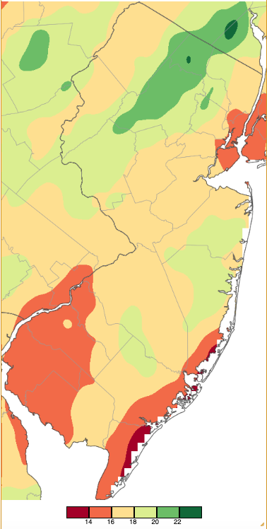
Figure 9. Winter 2023/24 (December 1st–February 29th) precipitation across New Jersey based on a PRISM (Oregon State University) analysis generated using NWS Cooperative and CoCoRaHS observations. Note the scale in full inches at the bottom of the map. Totals range from 12.00”–13.99” (dark red) to 22.00”–23.99” (dark green).
Looking at the snow season through the end of winter, mindful that no snow fell in October and November, the statewide winter (and season-to-date) total stands at 15.1”. This is 4.6” below normal for the December–February period. The northern division (Warren, Morris, and Essex counties and those to the north) is at 22.1” for the winter, which is 3.7” below normal. The central division (Hunterdon, Somerset, Union, Middlesex, Monmouth, and Mercer) averaged 18.2” for the winter, which is 3.4” below normal. The southern division (Burlington and Ocean southward) averaged 9.8”, which is 5.6” below normal.
The six CoCoRaHS stations with the most snowfall through February include Montague (Sussex) with 33.0”, Franklin Township (Hunterdon) 30.1”, Vernon Township (Sussex) 30.1” and 29.3” (two sites), Stillwater Township (Sussex) 28.7”, and Frenchtown (Hunterdon) 27.8”. The least snowy locations are in the southeast, led by Lower Township with 1.5”, Little Egg Harbor Township (Ocean) 2.8”, Wildwood Crest (Cape May), Woodbine (Cape May), and another Lower Township station all at 3.0”, and 4.0” and 5.0” at two Brigantine (Atlantic) stations.
Winter maximum temperatures were in the 60°s for much of the state except in the northwest and in some coastal areas where only the upper 50°s were achieved (Figure 10).
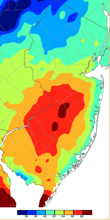
Figure 10. Extreme maximum temperatures during winter 2023/24 based on a PRISM (Oregon State University) analysis generated using NWS, NJWxNet, and other professional weather stations. The seasonal maximum occurred on different days at different locations.
On the low end of the thermometer, seasonal single digit lows were found in the northwest. Lows in the 10°–14° range were common over the remainder of the state except in urban and coastal areas, where temperatures never fell below the mid to upper teens (Figure 11).
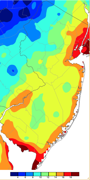
Figure 11. Extreme minimum temperatures during winter 2023/24 based on a PRISM (Oregon State University) analysis generated using NWS, NJWxNet, and other professional weather stations. The seasonal minimum occurred on different days at different locations.
For those seeking more detailed information on 5-minute, hourly, daily, and monthly conditions, please visit the following Office of the NJ State Climatologist's websites:
Rutgers NJ Weather Network
NJ Community Collaborative Rain, Hail and Snow Network
NJ Snow Event Reports
Interested in receiving our monthly summaries at the end of each month? Send us your e-mail address here to join the mailing list.
Past News Stories

