Bitter Cold, a Blizzard, and a Thaw: January 2018 Summary
New Jersey State Climatologist
Center for Environmental Prediction, School of Environmental and Biological Sciences/NJAES, Rutgers University
February 5, 2018
Overview
The first month of 2018 was replete with cold, warmth, snow, rain, and stretches of dry weather. First came an impressive episode of subfreezing conditions that began in late December and extended into the second week of January. This interval included a storm that brought over 10” of snow and blizzard conditions to coastal counties. Next was a heavy rain event accompanied by much warmer air, then later in the month, several scattered rain and snow episodes interspersed with dry conditions and some 60° warmth. Something for most everyone, I suppose you could say!
The statewide January mean temperature was 29.2°. This is 1.5° below the 1981–2010 mean and ranks as the 55th coldest January of the 124 since 1895. It was the coldest January since 2015. Precipitation (rain and melted snow) across NJ averaged 2.69”, which is 0.71” below average for the month. This was the 39th driest on record and the lowest total since 2010. January snowfall across the state averaged 8.3”, which was 1.1” above average. Northern counties averaged 7.9” (-1.4”), central ones 6.9” (-1.0”), and the south on top with 9.2” (+3.4”). Through January, this snow season has brought an average of 17.0” (+4.1”) to New Jersey, with the north at 16.6” (-0.8”), central 14.7” (+0.3”), and south 17.0” (+4.1”).
Temperature
Frigid conditions prevailed though the first week of January. All 60 NJWxNet stations remained below freezing during this period, except for three of them on the 3rd and two on the 4th. This continued a string of subfreezing days that began on December 27th (at all but one station). Long-running National Weather Service Cooperative stations came close to record durations of subfreezing temperatures. In the northwest, Sussex (Sussex County) had 15 consecutive subfreezing days, which tied for the 7th longest streak. The record at this location remains 21 days in January 1895. The most recent longer streak was 16 days, ending on January 29, 2003. In central NJ, New Brunswick (Middlesex) saw a streak of 14 days, which fell short of a 16-day run that ended on February 4, 1961, and a 15-day run ending on February 20, 1979. The Atlantic City Airport in Pomona (Atlantic) had a 12-day streak ending on January 7. This was the 4th longest run, just missing a 13-day run ending on January 23, 1977, as well as two 14-day streaks ending on February 18, 1919, and January 12, 1968.
As a sign of the wide swings in January temperatures, ten days saw at least one location equal or exceed 50° for a maximum, with six of those days getting over 60°. Meanwhile, 17 days found at least one station below 10° for a minimum, with eight of those days falling below zero. It took until the 11th for mild conditions to arrive, with Oswego Lake (Burlington) rocketing to 65°, and Hammonton (Atlantic) and Mullica (Atlantic) at 64°. The 12th nudged out several other days to reign as the mildest day of January. West Deptford (Gloucester) topped out at 67°, eight stations reached 66°, and 39 others were between 60°–65°. The far southern tip of the state was coolest, only reaching 49° at West Cape May (Cape May). The 13th ended this brief mild spell, with 64° at Stewartsville (Warren) and 60°–62° at 35 locations (more on the 13th later in this section).
Mild conditions returned on the 20th, led by 58° highs at Egg Harbor Township (Atlantic), Mansfield (Burlington), and Oswego Lake. Woodbine (Cape May), Egg Harbor Township, and Cape May Court House (Cape May) reached 56° on the 21st. Hammonton and Piney Hollow (Gloucester) rose to 66° on the 22nd, with 20 stations between 60°–65°. Woodbine hit 66° and Vineland (Cumberland) 64° on the 23rd, with 34 locations between 60°–63°. Oswego Lake got to 62° and Vineland 61° on the 27th, Sea Girt (Monmouth) hit 58° and Toms River (Ocean) 57° on the 28th, and Wayne (Passaic) 50° on the 29th.
As the ball dropped in Times Square to signal the start of 2018, so did the thermometer. Minimum temperatures on the 1st were led by the cold northwest valley station in Walpack (Sussex) with a bone chilling -16°. No other station was close to that mark, but cold still prevailed at Pequest (Warren) with -7°, High Point Monument (HPM; Sussex) -6°, and High Point (Sussex) -4°. All other NJWxNet stations were between -3° and +9°, except for a “balmy” 11° in West Cape May. Walpack was -2° and HPM 3° on the 2nd. Walpack fell to -9° on the 3rd, with Berkeley Township (Ocean; a prime Pinelands radiational cooling site) at -5° and 50 other stations between -2° and 10°. HPM was 7° and High Point 9° on the 4th, and HPM was -2° and High Point -1° on the 5th. HPM got down to -4° and High Point -3° on the 6th, when all other NJ stations were -1° to 10°. Daytime highs on the 6th only made it up to 3° at HPM, 6° at High Point and Wantage (Sussex), and 8° in Charlotteburg (Passaic).
The 7th was the coldest day of the two-week frigid spell, with Walpack at -16°, Hopewell Township (Mercer) -13°, and Basking Ridge (Somerset) -10”. Some 23 stations were between -7° and -1°, with the least cold location being West Cape May at +7°. Berkeley Township and Oswego Lake were coldest at 5° on the 8th. Walpack dipped to 5° and Pequest 8° on the 10th.
Following a few days of warmth, the bottom fell out of the thermometer on the 13th. From an early day maximum of 58° at High Point Monument, the temperature plummeted to 6° by late evening. In fact, the temperature was down to 15° by 7:45 AM, when a 60 mph wind gust resulted in a wind chill of -11°. Thus, there was a remarkable 69° difference in how one felt outside over an eight hour period. High Point went from 59° to 7° on the 13th, while Stewartsville, the warm spot that day at 64°, dropped to 15° by midnight. Figures 1–4 illustrate this precipitous decline. Figure 1 shows the cold front making its way across NW NJ. High Point had already fallen from a midnight temperature of 59° to the upper 30°s (Figure 2). Most of the remainder of the state was close to 60°, with the exception of coastal areas, which, chilled by the adjacent cold (or frozen) water, sat in the 40s to low 50s.
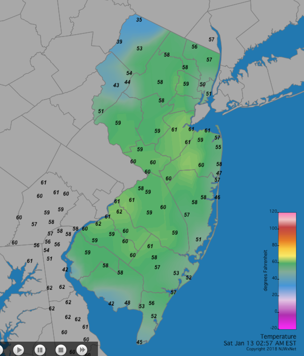
Figure 1. Statewide temperatures at 2:57AM on January 13th.
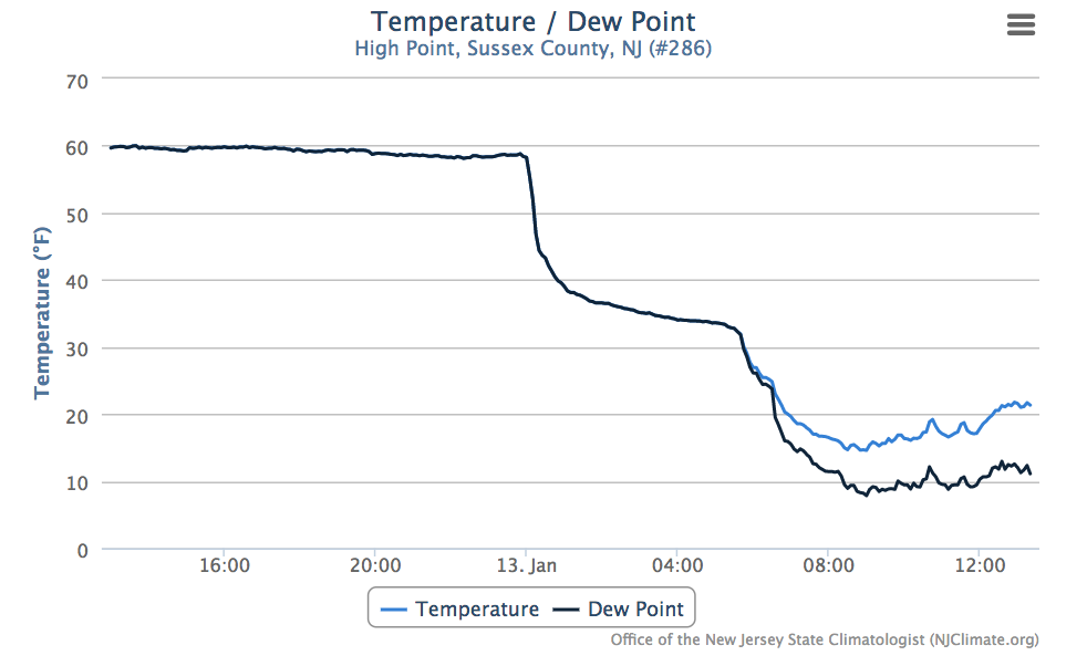
Figure 2. Temperature and dewpoint temperature at the NJWxNet High Point station for the 24 hours between early afternoons on the 12th (left) to 13th (right). Both variables were equal (the air was saturated) until about dawn on the 13th, when the dewpoint dipped below the air temperature.
By 8:57 AM the cold front was through NJ (Figure 3), with the south in the 30°s but yet to see freezing temperatures. Another step-like drop in temperature occurred at High Point close to sunrise, placing that area in the upper teens by this time. The front had yet to clear southeastern New England or the Tidewater of Virginia, with Boston and Norfolk still near 60° (Figure 4).
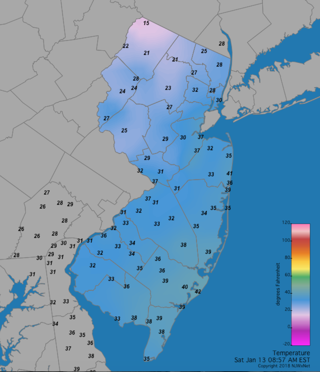
Figure 3. Statewide temperatures at 8:57AM on January 13th.
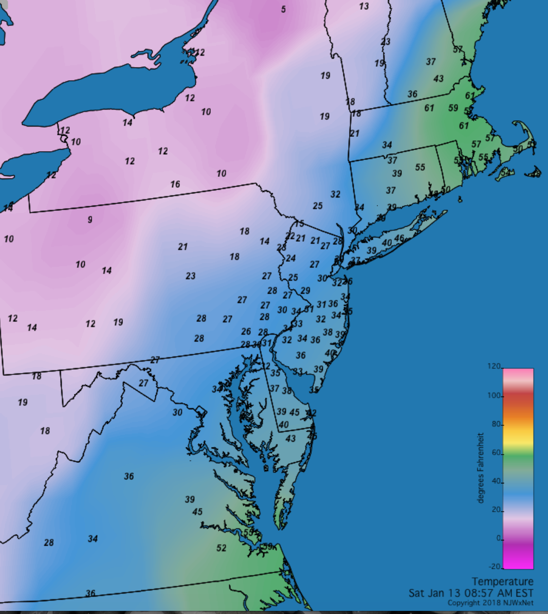
Figure 4. Mid-Atlantic temperatures at 8:57AM on January 13th.
HPM fell to 2° on the 14th and 4° on the 15th. Walpack and Pequest led the way from the 17th–19th with the former in at 1°, -6°, and -3°, respectively, and the latter at 4°, -3°, and 1°. There was a 30° difference in minimums across NJ on the 19th, as Atlantic City Marina (Atlantic) only fell to 27°. Closing out the month, Walpack bottomed out at 8° and Berkeley Township 9° on the 26th, with HPM to 6° and Walpack and High Point each at 8° on the 31st.
Precipitation and Storms
There were four storms in January that deposited at least an inch of precipitation (rain or melted equivalent of snowfall) at some NJ locations. This resulted in precipitation totals as high as 4.66” in Ringwood (Passaic), with other hefty totals of 4.55” in Rockaway Township (Morris), three stations in Randolph (Morris) at 4.55”, 4.39”, and 4.37”, Mt. Arlington (Morris) 4.52”, Jefferson Township (Morris) 4.39”, Mine Hill (Morris) 4.26” and 4.24”, and Montague (Sussex) 4.25”. While the Highlands saw the most precipitation, not too far to the south and east, the lowest totals were found in the Piedmont. This included 1.86” and 2.10” at two Woodbridge (Middlesex) sites, Westfield (Union) 1.94”, Plainsboro (Middlesex) 2.12”, Palisades Park (Bergen) 2.13”, and two Franklin Township (Somerset) locations, each with 2.20”.
There were three January events where at least 2.0” of snow accumulated somewhere in the state. Coastal counties saw the most, with 21.0” and 17.8” recorded in Long Branch (Monmouth), 21.0” in Brick (Ocean), Berkeley Township 20.9”, Stafford Township (Ocean) 20.0”, Freehold (Monmouth) 17.7”, and Point Pleasant Beach (Ocean) and Toms River 16.8”. Totals of less than 10.0” were more common elsewhere in the state.
The first storm was certainly the month’s most impactful one. Snow began from south to north during the evening of the 3rd. Snow continued throughout the morning and afternoon of the 4th, bringing prodigious amounts to eastern areas, winds gusting over 40 mph in many locations, and some minor to borderline moderate coastal flooding. Blizzard conditions were experienced in some locations during the height of the storm, meaning that for at least three consecutive hours winds were over 35 mph and visibility below a quarter of a mile in falling or blowing snow. Peak gusts on the 4th were 65 mph at High Point Monument, Cape May (Cape May) 59 mph, Lakehurst (Ocean) 57 mph, Fortescue (Cumberland) 55 mph, Tuckerton (Ocean) 53 mph, Sea Girt 50 mph, and Atlantic City Marina 50 mph, with 15 other NJWxNet stations gusting from 40–49 mph.
Snowfall exceeded 10” at locations in the four coastal counties, accumulating to 15.5” in Ocean City (Cape May), 16.0” in Margate City (Atlantic), 19.5” at Brick, and 18.0” at Long Branch. Five inches or more was measured in 16 other counties. The least fell in Warren County, with, at best, 4.5” in Hackettstown, and the least being 2.0” in Blairstown (Figure 5). The distribution of snowfall was reminiscent of the December 26–27, 2010 storm, only the 2018 totals were upwards of a foot less in the eastern two thirds of the state and several inches less in the west. The water content of the snow was as high as 2.29” in Long Branch, 1.79” in Howell (Monmouth), and 1.54” at Point Pleasant Beach. Only 0.13” was measured in Flemington (Hunterdon) and 0.20” in Denville (Morris) and Washington Township (Warren).
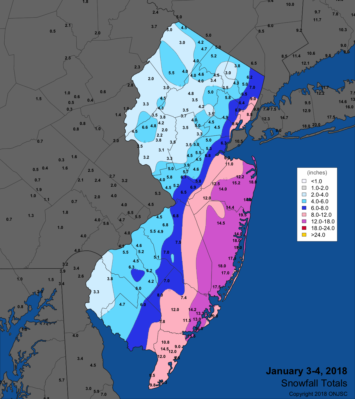
Figure 5. Snowfall totals from January 3rd–4th.
Warm air and heavy rainfall invaded the state from the morning of the 12th into the early hours of the 13th. Totals exceeded an inch along and northwest of NJ Turnpike, tapering to under a half inch near the coast. Top honors went to the Highlands region, with Rockaway Township catching 2.86”, three gauges in Randolph Township receiving 2.86”, 2.81”, and 2.66”, Mount Arlington 2.76”, and Ringwood 2.74”. Of the 195 NJ CoCoRaHS reports, 36 exceeded 2.00” and 68 were between 1.00”–1.99”. Some local flooding occurred, with small streams slightly exceeding their banks, however, no damage was reported.
The evening of the 16th brought snow to the northwest, which made it into central areas during the early part of the 17th. In the south, mostly rain fell before tapering off in the afternoon. Sussex and Warren counties mainly received from 4”–6” of the white stuff, with nine other counties seeing spots with at least 2.0” accumulating. Wantage received 6.9”, Montague 6.6”, and two Blairstown observers measured 5.9” and 5.5”. Melted snow or rain amounted to as much as 0.53” in Wantage, 0.50” at Montague, 0.42” in Oxford Township (Warren), 0.41” in Freehold, and 0.40” in Bethlehem Township (Hunterdon), Holland Township (Hunterdon), Howell, and White Township (Warren).
On the 23rd, predawn rain moved up the western portion of the state before moving eastward during the morning. Locations in the northwest and southeast received over an inch, with closer to 0.50” falling along the NJ Turnpike corridor. Blairstown received 1.31”, Montague 1.21”, Middle Township (Cape May) 1.11”, and Port Republic (Atlantic) 1.00”. Thunder was even heard in Parsippany-Troy Hills (Morris). The Turnpike was a good dividing line between only a few tenths of an inch of rain to the north and as much as an inch in the far southeast during a rainfall event from the morning into afternoon of the 28th. Woodbine received 1.10”, Estell Manor (Atlantic) 1.10” and 0.89”, and Dennis Township (Cape May) 0.97”.
The overnight hours from the 29th into the 30th saw several inches of snow clip eastern Ocean and Monmouth counties. Long Branch came in with 3.0" and Toms River 2.8". A few daytime squalls on the 30th deposited as much as an inch or two in Camden and Gloucester counties. Elsewhere, just a few tenths to no snow was observed.
The highest January barometric pressures were observed across NJ on the 26th, generally ranging from 30.70”–30.75”. Lowest values were reached on the 13th at 29.30”–29.35”. In addition to the strong winds of the 4th mentioned earlier in this report, twelve other January days found one or more NJWxNet station gusting to 40 mph or higher. Eleven of them included strong gusts at High Point Monument. In the aftermath of the blizzard, the 5th brought gusts of 56 mph to HPM, 50 mph at Fortescue, and 13 other stations gusting from 40–44 mph. HPM reached 48 mph and Fortescue 41 mph on the 6th, and HPM 49 mph on the 7th. Peak gusts on the 12th include 40 mph at both Pennsauken (Camden) and HPM, 60 mph at HPM, 51 mph in Wantage and 45 mph at Atlantic City Marina on the 13th, and 42 mph at HPM on the 14th. HPM maxed out at 42 mph on the 18th, but failed to reach the 40 mph mark on the 23rd when Atlantic City Marina peaked at 42 mph. HPM was back in the game on the 24th at 49 mph and on the 25th with 43 mph. The 30th brought a gust of 54 mph to HPM and 40 mph in Seaside Heights (Ocean). HPM finished the month with a 42 mph gust on the 31st.
For those seeking more detailed information on hourly, daily and monthly conditions, please visit the following Office of the NJ State Climatologist's websites:
Rutgers NJ Weather Network
NJ Community Collaborative Rain, Hail and Snow Network
NJ Snow Event Reports
Interested in receiving our monthly summaries at the end of each month? Send us your e-mail address here to join the mailing list.
Past News Stories

