The Heat Goes On: November & Fall 2020 Recaps
New Jersey State Climatologist
Center for Environmental Prediction, School of Environmental and Biological Sciences/NJAES, Rutgers University
December 7, 2020
November Overview
November 2020 enters the New Jersey climate record book as the third warmest (tied with 2009; Table 1). The statewide mean of 49.2° was 4.0° above the 1981–2010 normal. This month joins six Novembers from this century among the seven warmest of the past 126 years.
| Rank | Year | Nov. Avg. Temp. |
|---|---|---|
| 1 | 2015 | 49.7° |
| 2 | 2006 | 49.6° |
| 3 | 2020 | 49.2° |
| 3 | 2009 | 49.2° |
| 5 | 2011 | 48.9° |
| 5 | 1975 | 48.9° |
| 7 | 2001 | 48.8° |
| 8 | 1931 | 48.7° |
| 9 | 1999 | 48.6° |
| 9 | 1994 | 48.6° |
Table 1. The 10 warmest Novembers across NJ since 1895.
Six of the past 12 months have ranked in the top nine for warmth. Of the first 11 months of 2020, only April and May averaged below normal. The average temperature for the first 11 months is 57.1°. This is 2.7° above normal and ranks as the second warmest such interval. Only 2012 was warmer, with both years likely to retain this ranking for the calendar year unless an extremely cold or warm December occurs, which, as this report is written, appears unlikely.
Monthly precipitation totals for November require an explanation that long-time readers of these reports have read previously on multiple occasions. The “dreaded” last-day-of-the-month significant precipitation event occurred in November. In the far southern counties, rain began prior to dawn on the 30th, but held off until daylight elsewhere. Moderate to heavy rain fell during the morning and early afternoon, resuming in the evening as a squall line moved through. All but some very light showers were over before midnight. So this rain should all go into the November record book, correct? No, this is not the case and here is the “catch.” Given that the vast majority of National Weather Service Cooperative and CoCoRaHS observers measure daily precipitation between 6–8 AM, the convention is such that this observation time signifies the end of the observing day, in this case for the 30th and thus for the month. Any precipitation falling after this time is entered on the next morning’s observation, namely the 1st of the new month. So while an observer might be inclined to enter all of the rain that fell on November 30th on their observation form for the 30th it would be improper to do so. In our monthly reports, Coop observations are employed in the generation of monthly statewide and divisional totals and departures as these stations have long periods of record. CoCoRaHS observations are used as the main source of individual station observations for events during the month or for month at these stations.
In this month’s report, we will report on the November 30th storm, rather than wait to discuss it in the December report. State and station precipitation totals for November will be presented for the “official” month (ending on the morning of the 30th except for airport and some Coop observations that were made at midnight on the 30th), and for the “unofficial” month (taking into account reports from the morning of December 1st). As such, the official statewide precipitation total for November was 3.91”. This was 0.30” above the 1981–2010 normal and ranks as the 43rd wettest of the past 126 years. The map in Figure 1 shows that the southern half of the state was on the wetter side of normal while the north on the dry side. This was seen in the divisional numbers that had the south come in with 4.43”, which is 0.98” above average 33rd wettest, while the north averaged 3.09”, which is 0.77” below average and ranks 78th wettest (49th driest).
A map is also displayed that included reports through the morning of December 1st (Figure 2). Note that the color scale is the same on both Figures 1 and 2. The unofficial November totals in Figure 2 are markedly higher throughout the state, particularly in the north where the heaviest of the 30th rains fell. While statewide and divisional totals are unavailable for this unofficial period, all of the state averaged above the long-term November normal.
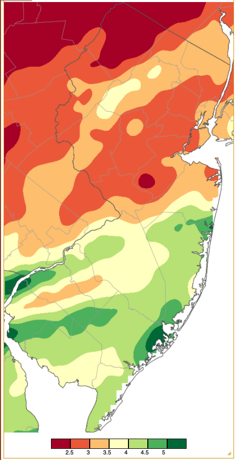
Figure 1. Official November 2020 precipitation across New Jersey based on a PRISM (Oregon State University) analysis generated using NWS Cooperative and CoCoRaHS observations from 7 AM on October 31 to 7 AM on November. Totals ranged from 2.00”–2.49” (red) to 5.00”–5.49” (dark green). See text for explanation of “official.”
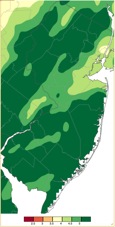
Figure 2. Unofficial November 2020 precipitation across New Jersey based on a PRISM (Oregon State University) analysis generated using NWS Cooperative and CoCoRaHS observations from 7 AM on October 31 to 7 AM on December 1. Totals ranged from 3.50”–3.99” (red) to 5.00”–7.49” (dark green). To facilitate a comparison with figure 1, the color scheme is the same as in Figure 1, except for the broader 5.00”+ category. See text for explanation of “unofficial.”
Temperature
As expected in a near record-breaking month of warmth, there were many days with daytime highs close to and exceeding record values. Nine November days found one or more NJWxNet stations reaching 70° or higher, and on five of these days a station rose to 77° or higher. Ten stations shared top honors with highs of 72° on the 5th, with 26 others of the 63 reporting stations at 70° or 71°. A narrow range of daily maximums found High Point Monument (HPM; Sussex County) coolest at 63°. This began an unusual week-long run of warmth. The 6th saw Basking Ridge (Somerset) at 75°, four locations at 74°, and 45 stations from 70°–73°. West Deptford (Gloucester) topped the charts at 78° on the 7th, followed by 17 stations at 77° and 42 spots from 70°–76°. Fortescue (Cumberland) felt the effects of a southerly wind blowing off the cooler Delaware Bay and only reached 63°. The 8th was one of, if not the warmest, day for so late in the season across most of the state. Basking Ridge reached 82°, Howell (Monmouth) and Mansfield (Burlington) hit 81°, and nine stations were at 80°. Some 48 others topped out from 70°–79°, with Fortescue, again, only up to 63°. Records again fell on the 9th, with Basking Ridge, New Brunswick (Middlesex), Hillsborough-Duke (Somerset), and Sandyston (Sussex) sharing top honors at 79°. 55 other NJWxNet locations reached 70°–78°, with Fortescue making it to 65°. Five locations hit 78° on the 10th, with 53° from 70°–77°. Perhaps Delaware Bay was warming, as Fortescue reached 67°, though again it was the lowest maximum in NJ. The siege of warmth ended on the 11th, with Oswego Lake (Burlington) at 77°, Dennis (Cape May) and Hammonton (Atlantic) each 76°, and 42 locations 70°–75°.
The atmosphere was quite dry and the skies clear during the first five days of this warm week before humidity levels and more clouds moved into the region. This contributed to the warm days but with long nighttime hours there were some cold nights, particularly in valley locations. This is well illustrated at Walpack (Sussex), the perennial best NJWxNet valley location for cold air drainage during the nighttime hours, yet often having mild daytime temperatures. The first five days of the warm spell led to impressive diurnal temperature ranges at Walpack of 41°, 47°, 50°, 50°, and 39°. This is best illustrated on the 8th, with a high of 79° and low of 29°, and the 9th with a high of 78° and low of 28°. The topographically-induced variability of low temperatures around the state is also strikingly apparent in the map of low temperatures on the morning of the 9th. (Figure 3). In Sussex County, minimum temperatures were as cold as 28° in Walpack and as mild as 62° atop the Mountain Creek ski area in Vernon Township.
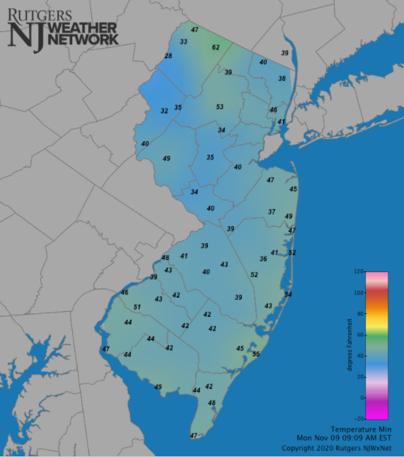
Figure 3. Minimum temperature on November 9, 2020. Reports are from Reports are from the Rutgers NJ Weather Network.
The New Brunswick station, a joint Coop and NJWxNet site, tells the story of the historic nature of this warm spell. Highs reached at least 70° each day from the 5th–11th. Record high temperatures were set on four straight days (7th–10th). The 80° reading on the 8th marked the latest in the fall season that New Brunswick has reached that mark, with records going back to 1912. The four consecutive daily record highs were also quite unusual. Only two other such runs exist at this benchmark NJ station, those being from January 13–16, 1932, and August 28–31, 1953. However, an impressive six-day run of record highs from June 2–7, 1925, still rules the record book.
Two later November afternoons saw 70° readings at West Creek (Ocean) on the 21st and at Howell and Oceanport (Monmouth) on the 26th. As a reminder that colder days are coming, the first day of the cold season with station maximums failing to exceed the freezing point occurred on the 18th. HPM only made it to 26° and four other stations topped out from 28°–31°.
On the colder daily minimum side of November’s thermal regime, eight days saw minimums of 25° or lower at one or more NJWxNet location. Walpack was the coldest on each occasion, but others stations joined in on five of these days. Walpack fell to 24° on the 4th. The 25° low at this site on the 14th began a streak of six days of sub-25° cold. On the 15th, Walpack fell to 22°, with Sandyston at 24° and Pequest (Warren) 25°. Walpack was alone at 24° on the 16th but its 22° on the 17th was joined by 23° in Sandyston, with four locations at 24°–25°. The first sub-20° cold of the season arrived on the 18th, with Walpack at 15°, High Point (Sussex) and Sandyston each 17°, five locations from 18°–19°, and 41 stations from 20°–25°. All 63 NJWxNet stations were at or below freezing that day except Atlantic City Marina (ACM; Atlantic), which bottomed out at 33°.
The New Jersey growing season finally ended on the 19th when ACM (31°) joined all other locations below freezing (Figure 4). Walpack was again 15°, followed by 16° at Hopewell Township (Mercer), Pequest, and Sandyston, 17°–19° at 11 spots, and 20°–25° at 37 stations. ACM had last fallen to freezing on March 1, thus there was a 262-day interval of above-freezing temperatures. This contrasted rather remarkably from the shortest growing season of 2020 at, not surprisingly, Walpack, where the last spring freeze was on June 1st (the first day of climatological summer) and the first fall freeze on September 19th (still in astronomical summer). This led to a 109-day growing season, some 153 days shorter than at coastal ACM.
One additional sub-25° November morning was felt on the 29th in Walpack at 20°, with Hopewell Township, Sandyston, and Pequest each at 23°, and 25° in Berkeley Township (Ocean).
Figure 4. Minimum temperature on November 19, 2020. Reports are from the Rutgers NJ Weather Network.
Precipitation and Storms
As discussed (at some length!) earlier, official November totals do not include rainfall for the bulk of the storm on the 30th. With that in mind, the highest official monthly total was 5.99” in Absecon (Atlantic). This was followed by 5.94” in Galloway (Atlantic), Wall Township (Monmouth) 5.90”, Brick Township (Ocean) 5.68”, Linwood (Atlantic) 5.50”, and Brigantine (Atlantic) 5.41”. Unofficial totals that include the 30th storm increase to maximums of 7.59” at Califon (Hunterdon), with Absecon falling to second highest with 7.25”. The lowest official totals included 2.04” in Andover (Sussex), Newton (Sussex) 2.11”, Blairstown (Warren) 2.19”, Hardyston (Sussex) 2.19”, Red Bank (Monmouth) 2.27”, and Franklin Township (Somerset) 2.28”. Unofficial (through the morning of December 1st) minimum totals rose to 3.69” in Red Bank and 3.76” at Edison (Middlesex). Andover increased to 4.11”. Snow flurries were spotted on several November days, however, no measurable snow was observed anywhere in the state.
Afternoon and evening rain on the 1st deposited 1.05” at Stafford Township (Ocean), and 1.00” in both Ventnor (Atlantic) and Absecon. A few flurries fell in the north on the 2nd and heavy fog enveloped a number of locations, accompanied by a bit of drizzle on the 5th. Dry conditions then prevailed until some northern predawn showers on the 11th.
More widespread rain began that afternoon and continued into the morning of the 12th, especially in the south, before resuming in central and northern regions later on the 12th. The remnants of Hurricane Eta contributed to the flow of moisture into the region, thus the notable totals noted here. Manasquan (Monmouth) received 3.29”, Franklin Township (Gloucester) 3.28”, Upper Deerfield (Cumberland) 3.25”, Pittsgrove (Salem) 3.19”, Fairfield Township (Camden) 3.12”, Howell 3.07”, and Haddon Heights (Camden) 3.03”. Some 58 of the 260 CoCoRaHS reports came in from 2.00”–2.99” and 146 from 1.00”–1.99”. Northwest areas saw the least, with 0.59” in Stillwater (Sussex) and 0.62” at Blairstown. Figure 5 shows the totals for the 24-hour period when the bulk of the rain fell.
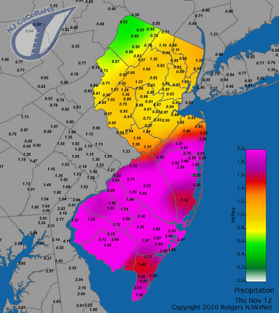
Figure 5. Rainfall from approximately 7 AM on November 11th to 7 AM on November 12th. Reports are from CoCoRaHS observers.
A strong squall line moved from west to east across NJ on the evening of the 15th (Figure 6). Lightning was observed in some locations and pea-size hail fell in Vernon Township. Strong winds brought down trees, some onto houses, and powerlines fell, resulting in sporadic outages. Wind gusts at professional stations topped out as high as 65 mph in North Cape May (Cape May) and were from 60–63 mph in Brick Township, Mystic Island (Ocean), Vernon Township, Lower Alloways Creek Township (LACT; Salem), and Barnegat Light (Ocean). Eight NJWxNet stations gusted from 51–56 mph and 25 from 40–49 mph. Given the relatively quick-moving nature of the squall line, rainfall totals were no higher than 0.76” in Haddon Heights, 0.75” and 0.67” at two Middle Township (Cape May) stations, and 0.70” at both Far Hills (Somerset) and Maurice River (Cumberland).
The typical impacts of the squall line passage are seen in time series of weather variables at the Hillsborough-Duke station in central NJ (Figure 7). The air temperature quickly fell about 10° and the dewpoint close to 15°, winds gusted to 45 mph, yet rather quickly diminished following passage, and barometric pressure that had been steadily falling ahead of the line quickly rose before commencing a slow rise.
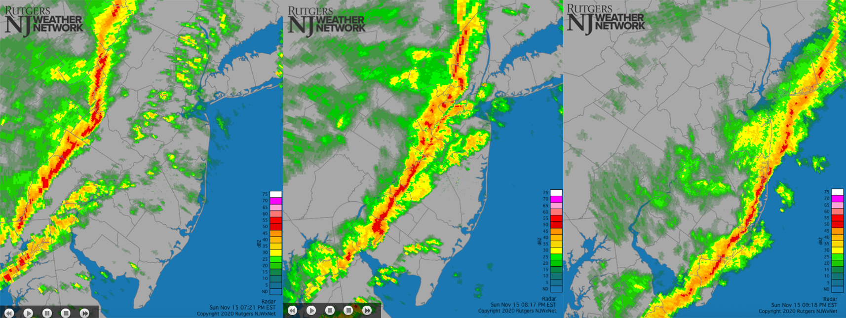
Figure 6. NWS radar on November 15th at 7:21 PM (left), 8:17 PM (center), and 9:18 PM (right).
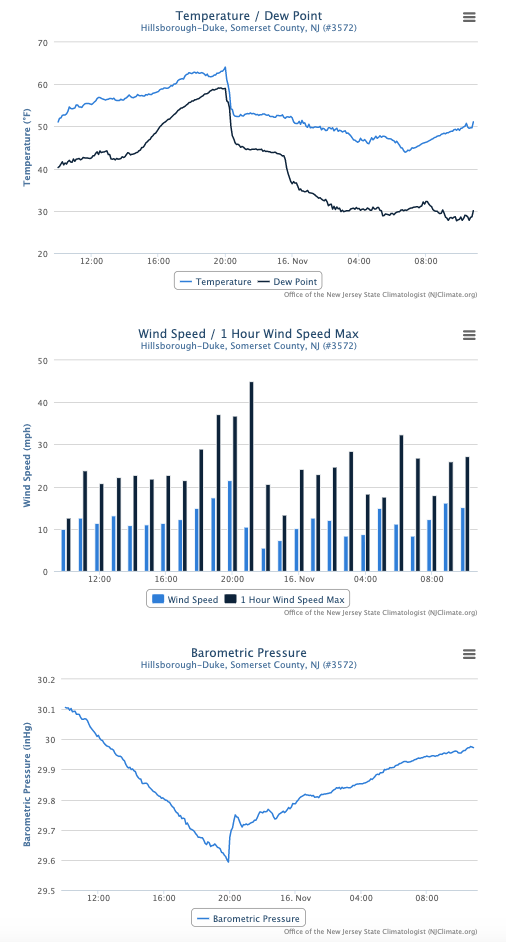
Figure 7. Time series of 5-minute temperature and dewpoint (top), wind speed and hourly maximum wind gust (center), and 5-minute barometric pressure (bottom) at the Hillsborough-Duke NJWxNet station from 10 AM November 15th to 10 AM November 16th.
A dry week followed but evening rain on the 22nd brought that to a close. Some thunder accompanied the tail end of the rain from about 5–7AM on the 23rd in south Jersey. Stafford Township received 1.30”, Point Pleasant Beach (Ocean) 1.27”, Berkeley Township 1.05”, and 85 of the 257 CoCoRaHS reporting stations caught from 0.50”–1.02”.
Rain arrived back in NJ late on the 25th, slowly tapering off on Thanksgiving morning the 26th. Central and northeast areas received the most, though no location topped an inch (Figure 8). Bedminster (Somerset) caught 0.91” followed by nearby Bridgewater Township (Somerset) with 0.89”, and Cranford (Union) at 0.81”. Some 111 of the 251 CoCoRaHS reports came in from 0.50”–0.80”, with a swath in the southwest only seeing about 0.10”.
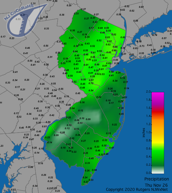
Figure 8. Rainfall from approximately 7 AM on November 25th to 7 AM on November 26th. Reports are from CoCoRaHS observers.
As mentioned previously, the rain on the 30th began prior to dawn in the southwest, making its way throughout the state in the post-dawn hours. The map below shows the bulk of the storm total, only missing, at most, several tenths falling in the southwest prior to morning observations (Figure 9). This was a statewide soaker, with the least rain falling at Wildwood Crest (Cape May) with 0.68” and in Middle Township at 0.76”. Elsewhere, of the 254 CoCoRaHS reports, 127 were between 1.00”–1.99”, 97 from 2.00–2.99”, and 16 greater than 3.00”. The top total of 3.77” was in Califon (Hunterdon), followed by 3.68” in Jefferson Township (Morris), Clinton (Hunterdon) with two stations each at 3.59”, Mount Arlington (Morris) 3.59”, Roxbury Township (Morris) 3.55”, Lebanon (Hunterdon) 3.54”, and Stillwater Township 3.51”.
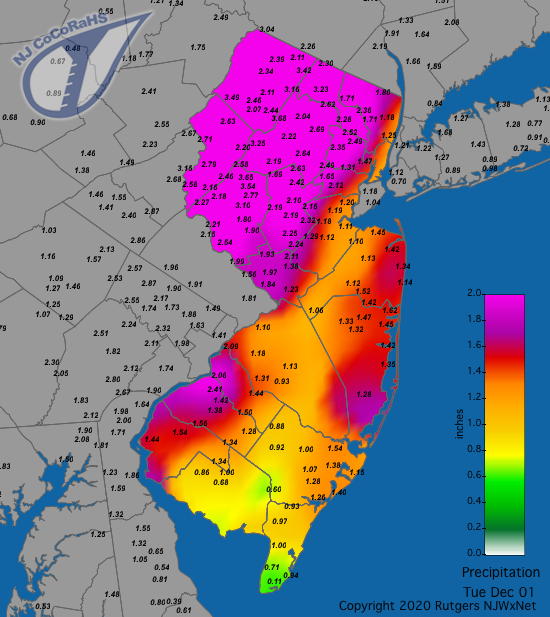
Figure 9. Rainfall from approximately 7 AM on November 30th to 7 AM on December 1st. Reports are from CoCoRaHS observers.
Winds on the 30th gusted to 59 mph at Fortescue, Vernon Township 58 mph, Sea Girt (Monmouth) 54 mph, and 50 mph at both Lyndhurst (Bergen) and LACT. Eight other stations gusted from 40–43 mph.
The highest barometric pressure readings in November occurred on the 18th at 30.55”–30.65” and 19th at 30.60”–30.65”. The lowest pressures were observed on the 30th at 29.30”–29.35”.
November was a windy month, with gusts at one or more NJWxNet station of at least 40 mph on 12 days. It is worth noting that two often windy stations, Seaside Heights (Ocean) and Harvey Cedars (Ocean), had anemometer issues and did not report in November. Gusts associated with the squall line on the 15th and the storm on the 30th have been discussed previously. The month began with gusts on the 1st up to 49 mph at Pennsauken (Camden), HPM 46 mph, and four locations from 41–43 mph. The second was an exceedingly windy day, with HPM up to 62 mph, Vernon Township 53 mph, Fortescue 51 mph, LACT 51 mph, and 22 NJWxNet stations gusting from 40–49 mph. HPM reached 48 mph and Vernon Township 44 mph on the 3rd. The 12th found HPM gusting to 40 mph. Following the windy 15th, the 16th saw a 51 mph gust at HPM and 42 mph at Fortescue. A windy week continued on the 17th with a gust to 45 mph at HPM, 44 in LACT, and 41 mph at Fortescue. HPM reached 55 mph on the 18th, with Sea Girt 43 mph, and Vernon Township 42 mph. The 19th saw Vernon Township up to 44 mph with the same location at 40 mph on the 20th. The 23rd found HPM gusting to 52 mph, Vernon Township 45 mph, LACT and Fortescue 42 mph, and Wantage 40 mph.
Fall 2020 Overview
Positive departures of 0.9° in September, 2.6° in October, and 4.0° in November conspired to make this New Jersey’s 6th warmest fall on record (tied with 2016 and 2017; Table 2). The 57.7° average was 2.5° above normal. Seven of the eight warmest falls since 1895 have occurred since 2005. This follows the 7th mildest winter (Dec. 2019–Feb. 2020) and second warmest summer.
| Rank | Year | Fall Avg. Temp. |
|---|---|---|
| 1 | 1931 | 58.5° |
| 2 | 2015 | 58.3° |
| 3 | 2005 | 58.0° |
| 4 | 2011 | 57.9° |
| 4 | 2007 | 57.9° |
| 6 | 2016 | 57.7° |
| 6 | 2020 | 57.7° |
| 6 | 2017 | 57.7° |
| 9 | 1961 | 57.2° |
| 10 | 1900 | 57.1° |
Table 2. The 10 warmest falls (September–November) across New Jersey since 1895.
The statewide fall precipitation average of 13.48” was 1.93” above normal and ranks as the 28th wettest. South Jersey, with as much as 19.28” in Galloway, ran as much as 10” above average (Figure 10). Other large totals included 19.15” in Absecon, Brigantine 19.14”, and Woodbine (Cape May) 18.78”. A few northwest areas, with under 10”, were more than 3” below average. Greenwich (Warren) only saw 9.24”, two Blairstown stations saw 9.69” and 9.96”, Holland Township (Hunterdon) 9.83”, Newton 10.34” and 10.36”, and Frenchtown (Hunterdon) 10.52”.
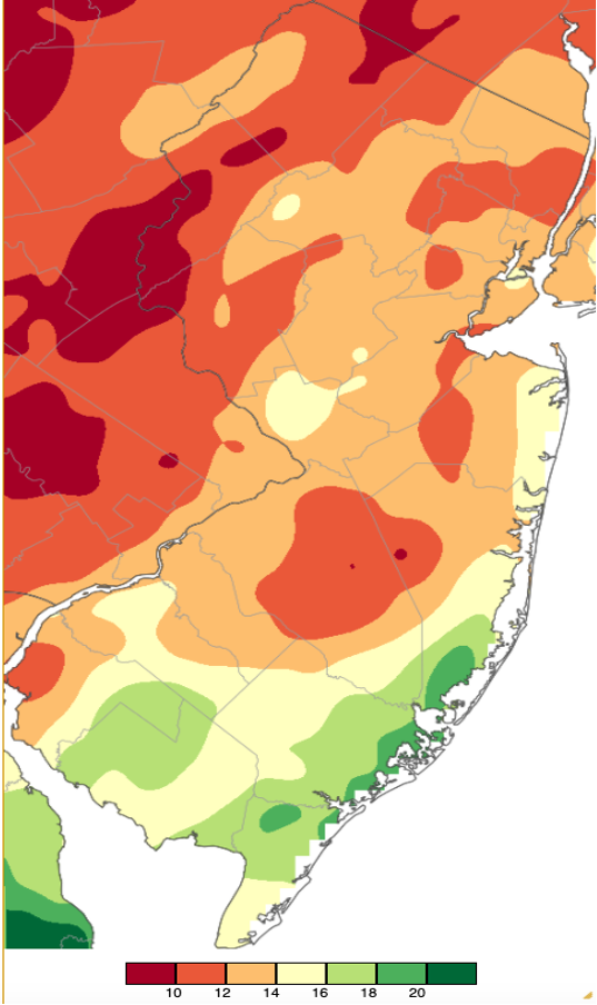
Figure 10. Official fall (Sep.–Nov.) 2020 precipitation across New Jersey based on a PRISM (Oregon State University) analysis generated using NWS Cooperative and CoCoRaHS observations from 7 AM on August 31 to 7 AM on November 30. Totals ranged from 8.00”–9.99” (red) to greater than 20.00” (dark green in Delaware). See text early in this report for an explanation of “official.”
For those seeking more detailed information on 5-minute, hourly, daily, and monthly conditions, please visit the following Office of the NJ State Climatologist's websites:
Rutgers NJ Weather Network
NJ Community Collaborative Rain, Hail and Snow Network
NJ Snow Event Reports
Interested in receiving our monthly summaries at the end of each month? Send us your e-mail address here to join the mailing list.
Past News Stories


