Tranquility: October 2023 Recap
New Jersey State Climatologist
Center for Environmental Prediction, School of Environmental and Biological Sciences/NJAES
Rutgers University
November 6, 2023
Overview
Foggy mornings, clear days, four modest rain events, and most locations yet registering a fall freeze. This all speaks to a rather quiet weather October, thus the title of this report. The rather dry conditions resulted in statewide monthly precipitation averaging just 2.16” (Figure 1). This was 2.03” below normal and ranked as the 32nd driest October since records commenced in 1895. Under an inch fell in the southwest, while only the northeast and northern coast saw totals close to or above normal. The northern climate division averaged 3.06” (-1.39”, 56th driest), southern division 1.57” (-2.46”, 17th driest), and coastal division 2.00” (-2.09”, 30th driest).
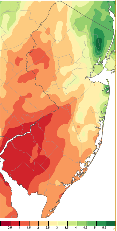
Figure 1. October 2023 precipitation across New Jersey based on a PRISM (Oregon State University) analysis generated using NWS Cooperative, CoCoRaHS, NJWxNet, and other professional weather station observations from approximately 8 AM on September 30th to 8 AM on October 31st. Note the scale in inches at the bottom of the map. Totals range from 0.00”–0.50” (dark red) to 5.50”–6.00” (dark green).
As a result of above-normal temperatures to begin and end the month, the statewide average temperature of 58.2° was 2.8° above normal, ranking 9th warmest (tied with 2019; Table 1). Every other October since 2017 sits in the top 10. The northern division averaged 56.4° (+3.1°, 9th warmest), southern 59.2° (+2.7°, 12th warmest), and coastal 60.2° (+2.6°, 11th warmest).
| Rank | Year | October Avg. Temp. |
| 1 | 2007 | 62.1° |
| 2 | 2021 | 61.0° |
| 3 | 2017 | 60.4° |
| 4 | 1971 | 59.8° |
| 5 | 1947 | 59.2° |
| 6 | 1990 | 58.7° |
| 6 | 1984 | 58.7° |
| 6 | 1949 | 58.7° |
| 9 | 2023 | 58.2° |
| 9 | 2019 | 58.2° |
Table 1. The ten warmest Octobers across NJ since 1895.
Temperature
There were 15 October days where one or more Rutgers NJ Weather Network (NJWxNet) stations reached a high of at least 75°. Ten of the days reached 80°, beginning on the 1st when four stations topped out at 81° and eight hit 80°. Mansfield (Burlington County) and West Deptford (Gloucester) warmed to 82° on the 2nd with 27 of the 67 NJWxNet stations at 80° or 81°. The warmth continued on the 3rd, with Basking Ridge (Somerset), Hillsborough-Duke (Somerset), and Mansfield up to 85° and 48 stations from 80°–84°. The month’s warmest day occurred on the 4th, with Basking Ridge at 87°, 15 stations either 85° or 86°, and 38 from 80°–84° (Figure 2). Harvey Cedars (Ocean), at 71°, was coolest. The 5th found Mansfield and Hammonton (Atlantic) up to 82° and 23 stations either 80° or 81°. The six-day string of 80° weather concluded on the 6th when six sites reached 80°.
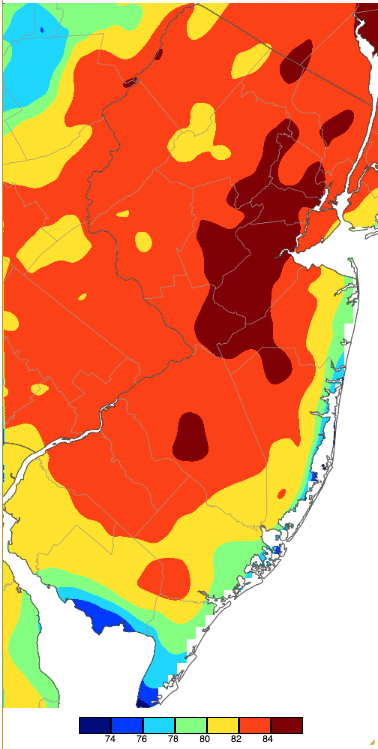
Figure 2. Maximum temperatures on October 4th based on a PRISM (Oregon State University) analysis generated using NWS, NJWxNet, and other professional weather stations. Note the 2° scale beneath the map.
Multiple stations topped out from 75°–79° on the 7th, 11th, 12th, and 25th, but it wasn’t until the 26th that a record-breaking warm spell delivered highs into the low 80°s. That day saw Hillsborough-Duke at 84° and 42 stations from 80°–83°, while Harvey Cedars was only up to 69°. Lower Alloways Creek Township (Salem) reached 81° on the 27th and five stations 80°. Five stations made it to 84° on the 28th, with 48 from 80°–83°. High Point Monument (Sussex) was coolest at a still mild 74°. The 30th saw Cape May Court House (Cape May) reach 82°, Oswego Lake (Burlington) 81°, and Egg Harbor Township (Atlantic) and Woodbine (Cape May) each 80°. The warmth failed to get above south Jersey on the 30th as High Point (Sussex) topped out at just 50°. Some daily record maximums were set or tied at times during the month. For instance, Atlantic City Airport in Pomona (Atlantic) set a record on the 28th at 82° and tied records on the 26th, 27th, and 30th. Also, Newark Airport (Union) and New Brunswick (Middlesex) had record highs on the 26th and 28th.
The first NJWxNet stations this fall to dip to the freezing point reached this mark on the 9th when Walpack (Sussex) and Sandyston (Sussex) each reached 32°, while three stations fell to 34° or 35°. Nine other October days with lows of 35° or cooler included the 10th with Pequest (Warren), Walpack, and Sandyston all at 35°. Pequest and Sandyston were 35° on the 12th. Walpack followed with 32° on the 13th and Sandyston 34°. Berkeley Township (Ocean) fell to 35° on the 14th. Next up was some south Jersey cold on the 19th with Berkeley Township at 34° and Oswego Lake and Woodbine at 35°.
The coldest spell of the month arrived on the 23rd, with Walpack down to 31° and seven stations 33°–35°. The 24th marked the coldest October morning, with Walpack at 28°, Pequest and Sandyston 30°, 12 NJWxNet stations 31° or 32°, and 15 from 33°–35° (Figure 3). Coastal Harvey Cedars was mildest at 49°. Walpack again made it to 32° on the 25th, with Hopewell Township (Mercer) 34° and Pequest 35°. Three coastal stations dropped to just 56°. Halloween found Walpack at 29° and four NJWxNet stations 30°–32°.
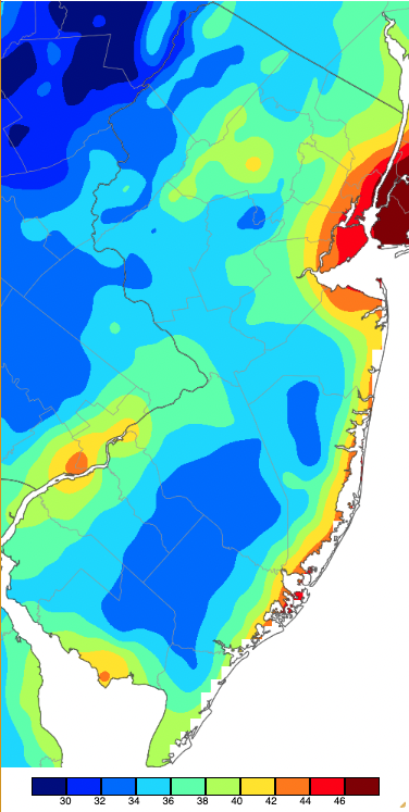
Figure 3. Minimum temperatures on October 24th based on a PRISM (Oregon State University) analysis generated using NWS, NJWxNet, and other professional weather stations. Note the 2° scale beneath the map.
Precipitation, Storms, and More
There were four rainy episodes during October where some locations picked up an inch or more precipitation. Early in the month, it was fog and yet another day this year of Canadian smoke that stole the show. Western Canadian wildfire smoke at high altitudes (that could not be smelled and was not harmful in NJ) moved over southeast NJ on the 1st. It took a circuitous path, heading first to eastern Canada and then pulled southeastward along the US East Coast by a low-pressure system off the coast, eventually reaching Florida (Figure 4 and Figure 5).
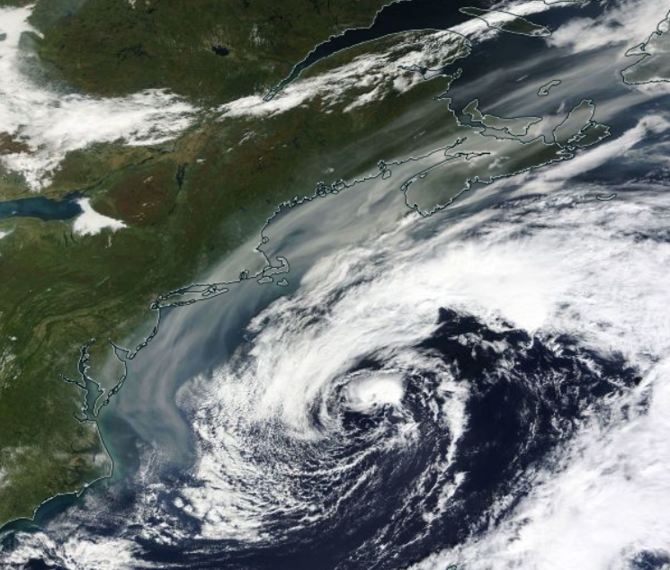
Figure 4. Smoke (gray shading) circulating around the back side of an offshore low on the morning of October 1st (NASA Terra).
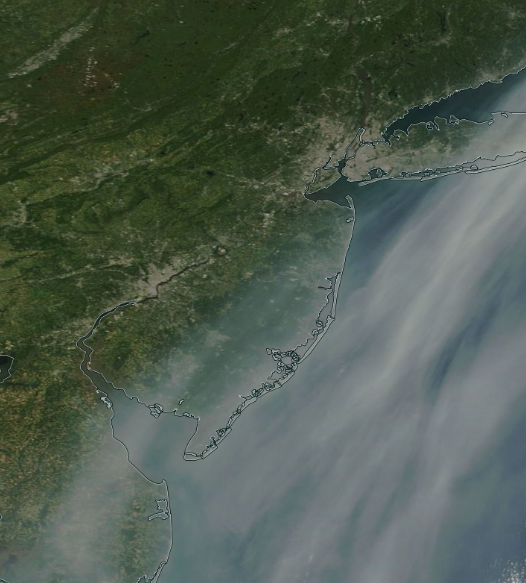
Figure 5. Close up of smoke over southeast NJ on the morning of October 1st (NASA Terra).
Clear, calm conditions, with plenty of surface moisture remaining from abundant late-September rain resulted in a number of foggy October mornings, particularly early in the month. This was most noteworthy in valley locations throughout the Northeast, as seen in Figure 6.
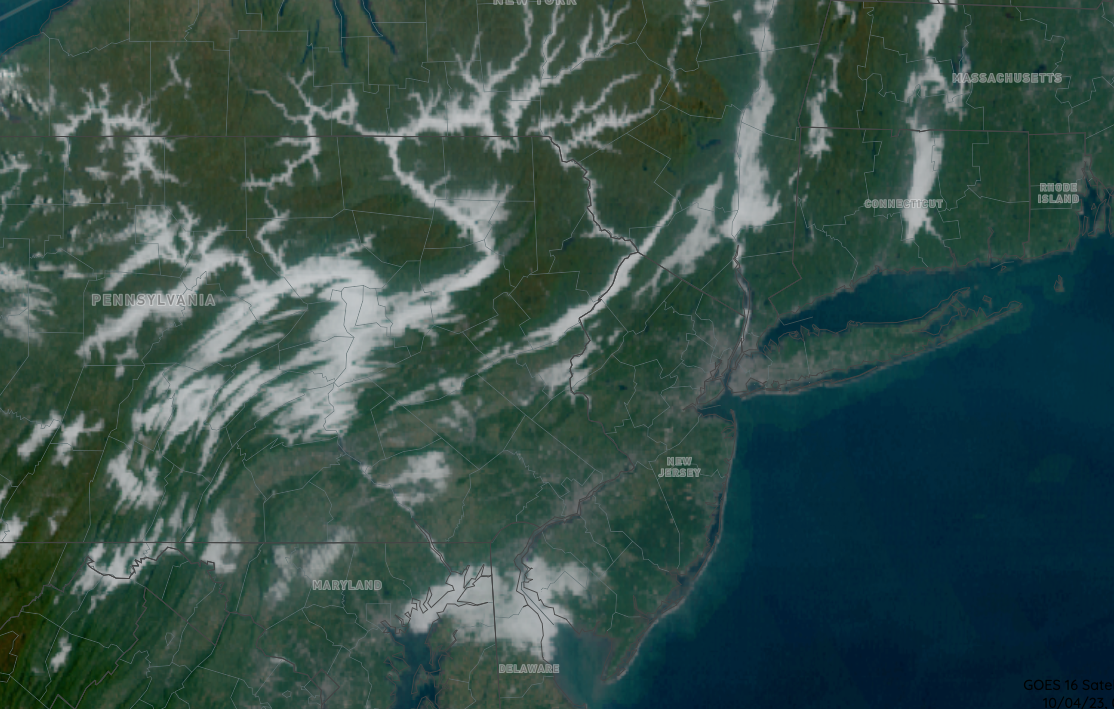
Figure 6. Valley fog in the Northeast at 9:30 AM on October 4th. Some clouds outside of valleys is seen from northeast Maryland east to Cumberland County, NJ (NOAA GOES).
The first rain event of the month came in two parts. First, showers on the morning of the 6th continued into the afternoon and evening, ending before dawn on the 7th. Of the 264 Community Collaborative Rain, Hail, and Snow Network reports, Hawthorne (Passaic) received the most rain at 2.01”. This was followed by Wayne (Passaic) with 1.72”, Little Falls (Passaic) 1.65”, and 1.65” and 1.60” (two stations) in Glen Rock (Bergen). Six stations saw 1.00”–1.47” and 16 from 0.50”–0.99”, the tight focus of these totals sitting over southern Passaic and western Bergen counties. After a short break, rain resumed later in the morning on the 7th extending through the evening. During this round, Vernon Township (Sussex) had two stations catch 1.64” and 1.48”, and along the northern coast, Brick (Ocean) saw 1.57” and Little Silver (Monmouth) 1.29”. Oakland (Bergen) received 1.12” and 26 locations from 0.50”–0.99”. The full event is mapped in Figure 7. Winds gusted to 40 mph at High Point Monument and Lower Alloways Creek Township on the 7th, the first of five October days with an NJWxNet station gusting to at least 40 mph.
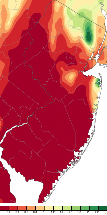
Figure 7. Precipitation across New Jersey from 8 AM on October 5th through 8 AM October 8th based on a PRISM (Oregon State University) analysis generated using NWS Cooperative, CoCoRaHS, NJWxNet, and other professional weather station observations.
A week passed before the next event began with light morning rain on the 14th. Rain was steady from the afternoon to the pre-dawn hours of the 15th. Totals were quite evenly distributed throughout most of the state (Figure 8). Top totals out of 258 CoCoRaHS reports included Wildwood Crest (Cape May) at 1.43”, Linwood (Atlantic) 1.31”, Newton (Sussex) 1.24” and 1.23” (two stations), 33 stations from 1.00”–1.22”, and 196 from 0.50”–0.99”. A gust reached 42 mph at Harvey Cedars on the 15th.
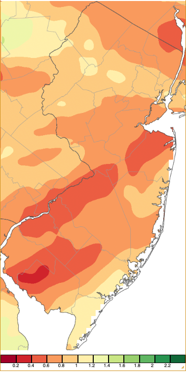
Figure 8. Precipitation across New Jersey from 8 AM on October 14th through 8 AM October 15th based on a PRISM (Oregon State University) analysis generated using NWS Cooperative, CoCoRaHS, NJWxNet, and other professional weather station observations.
Interrupting the weekly pattern of rain events was a system that mostly affected the northwest during the late afternoon and early evening of the 17th. It produced less than 0.25” of rain except at three Vernon Township stations that reported 0.56”, 0.45”, and 0.26” along with some hail that covered the ground.
The next larger weekly system arrived during the morning of the 20th, extending into the early evening. It then resumed overnight, ending late during the morning on the 21st. River Edge (Bergen) took top honors with 3.39”, followed by Harrison (Hudson) 2.78”, Wood Ridge (Bergen) 2.65”, North Arlington (Bergen) 2.60”, Maywood (Bergen) 2.56”, Lyndhurst (Bergen) 2.34”, and Kearny (Hudson) 2.07” (Figure 9). Forty CoCoRaHS stations caught from 1.00”–1.99”, and 77 from 0.50”–0.99”. This coastal storm brought the month’s lowest pressures of 29.25”–29.35” and, combined with approaching high pressure (which, on the 24th, brought the month’s highest pressures of 30.35”–30.45”), resulted in winds gusting over 40 mph from the 21st–23rd. Fortescue (Cumberland) reached 44 mph on the 21st, with Pennsauken (Camden), Lower Alloways Creek Township, and Little Egg Harbor Township (Ocean) all gusting to 41 mph. High Point Monument reached 42 mph and Vernon Township 41 mph on the 22nd, and High Point Monument hit 41 mph and Wantage (Sussex) 40 mph on the 23rd.
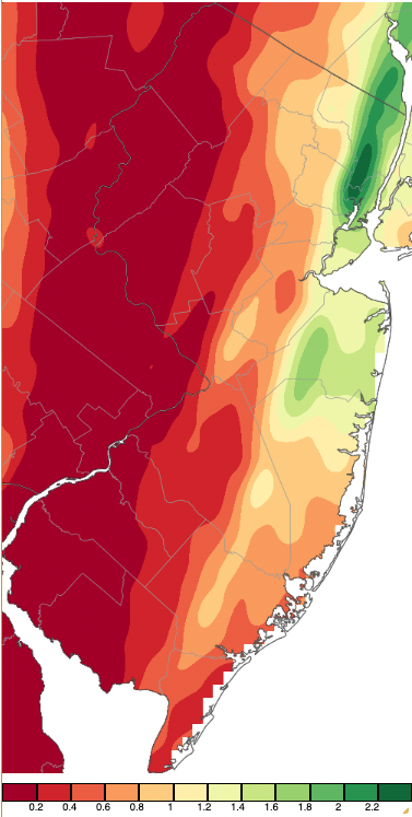
Figure 9. Precipitation across New Jersey from 8 AM on October 19th through 8 AM October 22nd based on a PRISM (Oregon State University) analysis generated using NWS Cooperative, CoCoRaHS, NJWxNet, and other professional weather station observations.
The roughly seven-day spacing between rain episodes continued at month’s end when showers arrived on the morning of the 29th, with rain lasting into the morning of the 30th. Making this “rhythm” quite annoying to many residents was the weekend timing of these events! This event again targeted the northeast with the heaviest totals, led by North Arlington with 1.47”, Harrison 1.41”, Warren (Somerset) 1.35”, Lyndhurst 1.33”, Cranford (Union) 1.31”, Newton 1.30”, and Maplewood (Essex) 1.28” (Figure 10). Nineteen stations caught from 1.00”–1.25” and 86 from 0.50”–0.99”.
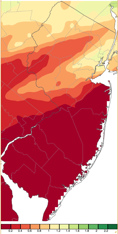
Figure 10. Precipitation across New Jersey from 8 AM on October 28th through 8 AM October 31st based on a PRISM (Oregon State University) analysis generated using NWS Cooperative, CoCoRaHS, NJWxNet, and other professional weather station observations.
Returning to monthly totals first shown in Figure 1, individual stations came in with as much as 6.51” in Harrison and as little as 0.50” at Upper Deerfield (Cumberland). Other prodigious values included North Arlington 6.43”, Lyndhurst 5.70”, Wood Ridge 5.57”, Maywood 5.36”, and Kearny 5.34”. A second Upper Deerfield station saw just 0.54”, a total shared with Hamilton (Atlantic) and Washington Township (Gloucester). Monroe Township (Gloucester) received 0.59”, Deerfield (Cumberland) 0.61”, Collingswood (Camden) 0.67”, and Burlington (Burlington) 0.74”.
For those seeking more detailed information on 5-minute, hourly, daily, and monthly conditions, please visit the following Office of the NJ State Climatologist's websites:
Rutgers NJ Weather Network
NJ Community Collaborative Rain, Hail and Snow Network
NJ Snow Event Reports
Interested in receiving our monthly summaries at the end of each month? Send us your e-mail address here to join the mailing list.
Past News Stories

