Frying Pan Persistence: July 2024 Recap
New Jersey State Climatologist
Center for Environmental Prediction, School of Environmental and Biological Sciences/NJAES
Rutgers University
August 12, 2024
Overview
Yet another warmer-than-normal July is in the books. This first sentence is just how last July’s report began. With a statewide average temperature of 77.9°, July 2024 ranked as the 7th warmest since records commenced in 1895. It was 2.5° above the 1991–2010 normal. The average high of 87.8° was 2.1° above normal, ranking 10th warmest. The average low of 68.0° was 2.9° above normal, ranking 3rd warmest. Eight of the ten warmest Julys have occurred since 2010 and ten of fifteen since 1999 (Table 1). Only three Julys in the past 25 years have averaged below the 1991–2010 normal. The June-July average of 75.8° is the second warmest, only exceeded by 76.1° in 2010. The year-to-date average through July of 55.2° also ranks second warmest following 55.7° in 2012. Within the northern climate division, the average was 76.6° (+2.9°, 4th warmest), southern 78.8° (+2.3°, 9th warmest), and coastal 77.7° (+1.5°, 12th warmest). Summing things up, this month’s report title seemed an appropriate choice.
| Rank | Year | July Avg. Temp. |
| 1 | 2020 | 78.8° |
| 2 | 2011 | 78.4° |
| 2 | 1999 | 78.4° |
| 2 | 1955 | 78.4° |
| 5 | 2010 | 78.3° |
| 6 | 2019 | 78.0° |
| 7 | 2024 | 77.9° |
| 7 | 2022 | 77.9° |
| 9 | 2013 | 77.8° |
| 9 | 2012 | 77.8° |
| 11 | 2023 | 77.2° |
| 11 | 2016 | 77.2° |
| 13 | 1949 | 77.0° |
| 14 | 1994 | 76.8° |
| 15 | 2006 | 76.7° |
Table 1. The 15 warmest Julys across NJ since 1895.
The 4.01” statewide average July precipitation was 0.70” below normal, ranking 52nd driest of the past 130 Julys. The north averaged 4.36” (-0.36’, 59th driest), south 3.77” (-0.97”, 51st driest), and coast 4.12” (-0.26”, 63rd driest; Figure 1).
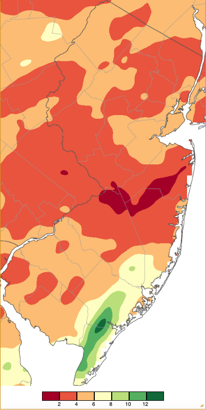
Figure 1. July 2024 precipitation across New Jersey based on a PRISM (Oregon State University) analysis generated using NWS Cooperative, CoCoRaHS, NJWxNet, and other professional weather station observations from approximately 8 AM on June 30th to 8 AM on July 31st. Note the scale in inches at the bottom of the map. Totals range from 0.00”–1.99” (dark red) to 12.00”–13.99” (dark green).
Temperature
High temperatures at one or more NJWxNet stations reached 90° on 22 July days with the 95° or higher mark reached on ten of those days. The first 95° day occurred on the 5th, with Cream Ridge (Monmouth County), Pennsauken (Camden), and Piney Hollow (Gloucester) all up to 97° and 16 stations at 95° or 96°. Lower Alloways Creek Township (Salem) and Pennsauken hit 99° on the 6th, with 25 stations from 95°–98°. A sea breeze kept Harvey Cedars’ (Ocean) high at 76°. A run of six 95° days continued on the 7th, with Lower Alloways Creek Township reaching 98°. Moorestown (Burlington) hit 99° on the 8th, with 17 stations 95°–97° and Harvey Cedars again just 76°. Cream Ridge, Hillsborough-Duke (Somerset), and Pennsauken reached 98° on the 9th, with 20 stations 95°–97°. Hillsborough-Duke hit 97° on the 10th.
A four-day run of 95° heat began on the 14th, with Pennsauken at 96°. Hamilton (Mercer) made it to 100° on the 15th, with two stations at 99° and 33 from 95°–98°. Again, Harvey Cedars was coolest at 82°. The 16th was the hottest day of the month. Cream Ridge and Hamilton (Mercer) each peaked at 101°, East Brunswick (Middlesex), Fort Dix (Monmouth), Red Lion (Monmouth), and Hillsborough-Duke each reached the century mark, ten stations rose to 99°, and 36 from 95°–98° (Figure 2). High Point Monument (Sussex) made it to 90° for the third time this summer. Harvey Cedars reached 83°.
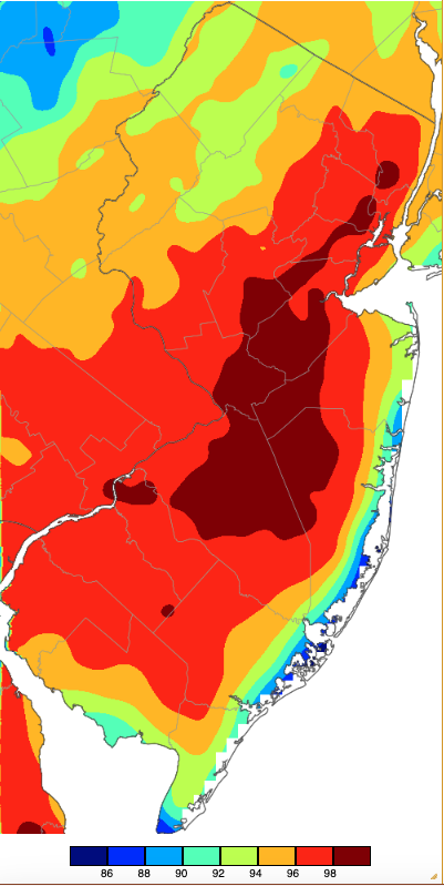
Figure 2. Maximum temperatures on July 16th based on a PRISM (Oregon State University) analysis generated using NWS, NJWxNet, and other professional weather stations. Note the 2° scale beneath the map.
As was often the case this month, the heat on the 16th was accompanied by high humidity. Figure 3 shows air temperatures across the region at 3:30 PM, illustrating (a) the inland heat and milder coastal temperatures, (b) dew point temperatures mostly in the 70°s, (c) relative humidity in the 30%–60% range inland and mainly 60%–70% along the coast, and (d) the heat index over 110° in the southwest down to 90°s close to the coast and at higher northwest elevations.
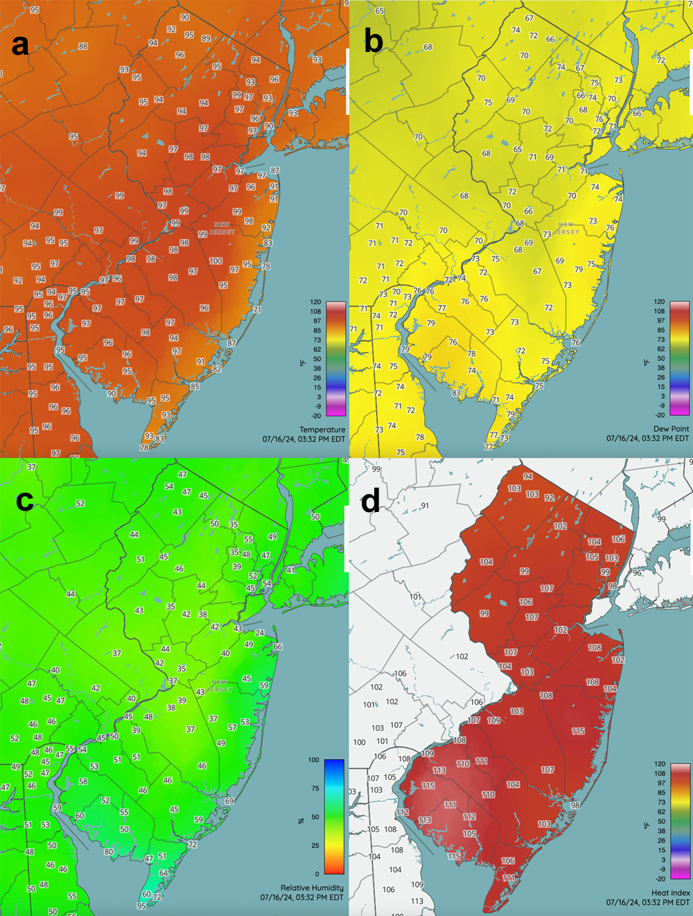
Figure 3. Conditions at 3:30 PM on July 16th. This includes air temperature (a), dew point (b), relative humidity (c), and heat index (d). Observations are from NJWxNet, NWS, and other professional weather stations.
The progression of temperature through a 24-hour period can vary greatly between coastal and inland locations, especially during hot conditions. This is well illustrated in time series of observations from inland Cream Ridge and coastal Harvey Cedars (Figure 4). The Cream Ridge progression shows a steady decline of temperature from the high 90°s during the afternoon of the 15th to a morning low in the mid 70°s on the 16th. A steeper rise to near 100° follows on the 16th. Also note the dew point temperature remaining in the sticky 70°s for most of the period. Meanwhile, a very different temperature pattern emerged at the coast. Fluctuations in wind direction from onshore to offshore resulted in frequent variations of the overall “chilled” air from the upper 60°s to low 80°s at Harvey Cedars. Notice that the mildest period was from mid-evening to early morning when the inland temperatures were less warm, thus the strength of the sea breeze was reduced. Not too often during the summer are overnight temperatures milder than daytime ones. This situation is mainly reserved for coastal locations during the height of summer warmth.
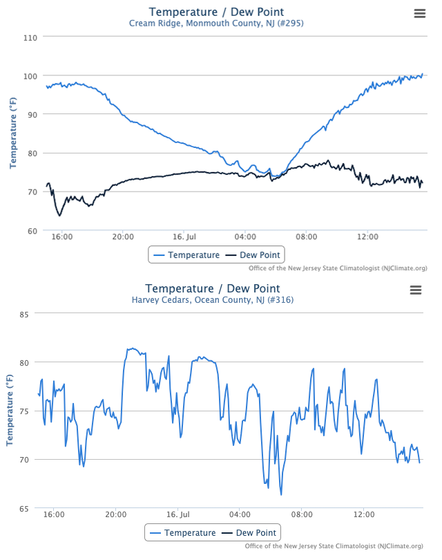
Figure 5. Time series of temperature and dew point at the Cream Ridge (top) and temperature at the Harvey Cedars (bottom) NJWxNet stations from approximately 3:00 PM on July 15th to 3:00 PM on July 16th.
The last 95° day of the month was the 17th with Hamilton (Mercer) at 98° and 18 locations from 95°–97°. However, highs from 90°–94° were observed at some NJWxNet stations on the 18th, 20th, 23rd, 25th, and 27th–31st.
Overnight low temperatures during July were often in the 60°s, except in urban and coastal areas that often ran in the 70°s. Eight days found one or more NJWxNet station with a low in the upper 40°s to low 50°s while 28 days had one or more station with a low in the 70°s to 80°. Looking at lows of 55° or cooler, the 1st found Walpack (Sussex) down to 53° and High Point Monument at 54°. The coolest July morning was the 2nd when Walpack dropped to 47° and seven stations from 50°–55° (Figure 5). Note the milder conditions in the aforementioned urban and coastal areas while northwest valleys south through the Pinelands were coolest.
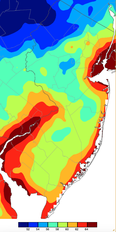
Figure 5. Minimum temperatures on July 2nd based on a PRISM (Oregon State University) analysis generated using NWS, NJWxNet, and other professional weather stations. Note the 2° scale beneath the map.
Walpack dropped to 52° and seven stations from 53°–55° on the 3rd. A wait of over two weeks ensued before low 50°s were again reached, with Walpack at 51°, Sandyston (Sussex) 53°, High Point Monument 54°, and Pequest (Warren) 55° on the 19th and Walpack 54° and Sandyston 55° on the 20th. Seaside Heights (Ocean) only dropped to 70° on the 19th. The final cooler spell of the month occurred from the 26th–28th, with Walpack at 49° on the 26th and 27th and several other stations in the low 50°s. Sandyston and Walpack were each 53° on the 28th, with five stations either 54° or 55°.
Of the 28 days with lows above 70°, the highest marks were achieved on the 6th when Lower Alloways Creek Township, Mannington (Salem), and Pennsauken only made it down to 80° and on the 10th when Lower Alloways Creek Township was 80°.
Wildfire
Hot and dry conditions in the southern Pinelands helped fuel a wildfire in Wharton State Forest at Tabernacle (Burlington) beginning on the 5th. Before being contained on the 8th, approximately 4,300 acres burned in this Tea Time Hill fire. No major structures were consumed or injuries reported. The same outcome emerged from the 1,200-acre Whip or Will wildfire at the Warren Grove Air to Ground Range in Bass River Township (Burlington) on the 16th–17th.
Precipitation and Storms
Despite July rainfall averaging slightly below normal across NJ, there were eleven events where one or more locations picked up more than an inch. Also, there were five days where storms produced wind gusts of 40 mph or higher at one or more NJWxNet stations. The storm on June 30th, with rainfall that day following morning observations, qualifies as July rain. Such was included in Figure 1 and in the monthly rainfall totals to follow. A discussion of that storm and a map showing totals for the event appeared in the June report.
Looking at July rainfall totals at NJ Community Collaborative Rain, Hail, and Snow Network and at NJWxNet stations, top amounts were found in the far south. These include two Woodbine (Cape May) stations with 12.07” and 12.00”, followed by Lower Township (Cape May) stations with 11.93”, 9.79”, 9.78” and 8.50”, a Middle Township (Cape May) site with 10.53”, and Hamilton Township (Atlantic) with 9.35”. On the dry end, stations in the northern portion of the south were lowest with Howell Township (Monmouth) at 1.51”, Jackson Township (Ocean) 1.82”, Willingboro Township (Burlington) 1.93”, Bordentown (Burlington) 1.98”, and Hamilton Township (Mercer) 2.02”. That’s a 7.33” difference between the two Hamilton Township communities!
Evening thundershowers on the 4th delivered 1.32” and 1.20” to two Washington Township (Warren) locations, 1.09” to Bernardsville (Somerset), and 1.06” in Clinton Township (Hunterdon). Rain during the morning hours of the 6th produced heavy totals along the border with New York. Mahwah Township (Bergen) received 2.47”, Ringwood (Passaic) 2.38”, West Milford Township (Passaic) 2.35”, Walpack 2.18”, Montague Township (Sussex) 2.16”, and Sandyston 2.66” (Figure 6). Of 245 CoCoRaHS reports, 18 stations caught 1.00”–1.99” and 37 0.50”–0.99”.
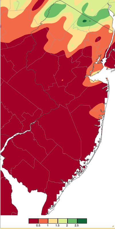
Figure 6. Precipitation across New Jersey from 8 AM on July 5th through 8 AM July 7th using NWS Cooperative, CoCoRaHS, NJWxNet, and other professional weather station observations. Note the scale in inches beneath the map.
Isolated storms on the 7th delivered 1.77” to Oswego Lake (Burlington), with the next highest totals of 0.64” and 0.39” at two Egg Harbor City (Atlantic) stations. Predawn rain in far south Jersey on the morning of the 12th continued through the 13th, ending early on the 14th. Prodigious totals included three Woodbine stations with 7.22”, 7.03”, and 6.18”, Dennis Township (Cape May) 6.21”, Middle Township 5.85” and 4.82” (two stations), and Hamilton Township (Atlantic) 5.50” (Figure 7). Six other stations received 4.00”–4.80”, 12 from 3.00”–3.99”, 13 from 2.00”–2.99”, and 31 from 1.00”–1.99”.
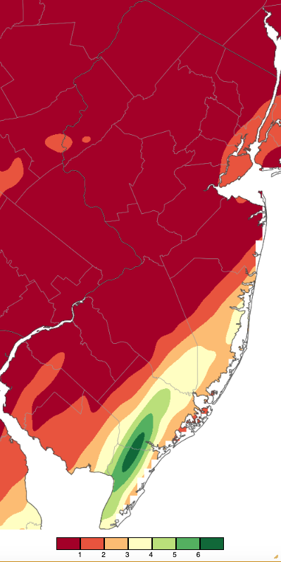
Figure 7. Precipitation across New Jersey from 8 AM on July 11th through 8 AM July 14th based on a PRISM (Oregon State University) analysis generated using NWS Cooperative, CoCoRaHS, NJWxNet, and other professional weather station observations. Note that the scale in inches beneath the map differs from Figure 6.
Afternoon storms on the 14th and early morning rain on the 15th brought Highland Park (Middlesex) 1.60”, New Brunswick (Middlesex) 1.58” and 1.42” (two stations), and South River (Middlesex) 1.58”. Fourteen stations caught 1.00”–1.60” and 26 from 0.50”–0.99”. Strong winds accompanying storms on the 14th included a gust of 47 mph at Moorestown and one of 49 mph at Pittstown (Hunterdon) on the 15th. Storm reports of downed trees and wires were submitted to the NWS by observers in six counties.
Late-afternoon thunderstorms on the 16th into early the 17th delivered heavy rain to scattered areas. This included three Lower Township stations with 2.58”, 2.03”, and 1.57”, Glassboro (Gloucester) 1.62”, Pitman (Gloucester) 1.58”, and Washington Township (Gloucester) 1.43”. Of 262 CoCoRaHS reports, 32 were from 1.00”–2.58” and 46 from 0.50”–0.99”. Strong winds brought down trees and wires in the early evening in six northern and central counties and during the late evening in four southern counties. Peak gusts on the 16th included 61 mph a Pittstown, Lower Alloways Creek Township 54 mph, and 40–47 mph at seven other NJWxNet stations, with a 48-mph gust at Fortescue (Cumberland) on the 17th. Pea size hail was reported in Frenchtown (Hunterdon).
Storms brought heavy rain to portions of northern and central NJ during the afternoon and evening of the 17th. Frelinghuysen Township (Warren) received 3.00”, Stillwater Township (Sussex) 2.32”, Newton (Sussex) 2.13”, Franklin (Sussex) 1.89”, Plainsboro Township (Middlesex) 1.86”, New Brunswick 1.70”, and Walpack 1.88” (Figure 8). This was the most widespread rain event of the month, with 55 CoCoRaHS stations receiving 1.00”–1.99” and 95 from 0.50”–0.99”. Winds brought down trees and wires in Sussex County during the afternoon and in Essex, Morris, and Middlesex counties during the evening. Hail as large as 3/8” fell in Frelinghuysen Township.
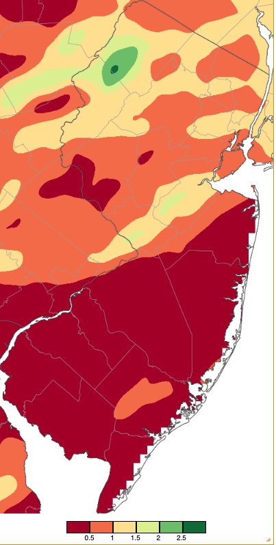
Figure 8. Precipitation across New Jersey from 8 AM on July 17th through 8 AM July 18th based on a PRISM (Oregon State University) analysis generated using NWS Cooperative, CoCoRaHS, NJWxNet, and other professional weather station observations. Note that the scale in inches beneath the map is the same as in Figure 6.
Scattered thunderstorms brought local inch plus rains on the 21st, 22nd, 24th, and 25th. Early evening storms on the 21st saw Moorestown catch 1.34”, Cinnaminson Township (Burlington) 1.17”, and Woodland Township (Burlington) 1.00”. Afternoon storms on the 22nd saw Montvale (Bergen) receive 1.32”, Chatham (Morris) 1.22”, Parsippany (Morris) 1.17”, Morris Township (Morris), and Morristown (Morris) 1.02”. Cherry Hill (Camden) accumulated 1.90” during an afternoon storm on the 24th, with Evesham Township (Burlington) seeing 1.88”, Cape May Court House (Cape May) 1.60”, Berlin (Camden) 1.38”, and Middle Township 1.15”. Southern storms on the 25th brought Ventnor City (Atlantic) 1.45”, four Lower Township stations 1.45”, 1.17”, 0.98”, and 0.90”, and Middle Township 1.13”. While only producing 0.64” of rain at Lower Alloway Creek Township on the 31st, the station observed a 48-mph gust.
The highest barometric pressures of the month ranged from 30.25”–30.30” on the 2nd. The lowest pressures ranges from 29.70”–29.80” on the 5th, 16th, and 17th.
For those seeking more detailed information on 5-minute, hourly, daily, and monthly conditions, please visit the following Office of the NJ State Climatologist's websites:
Rutgers NJ Weather Network
NJ Community Collaborative Rain, Hail and Snow Network
NJ Snow Event Reports
Interested in receiving our monthly summaries at the end of each month? Send us your e-mail address here to join the mailing list.
Past News Stories

