The Beat Goes On: August 2020 & Summer Recaps
New Jersey State Climatologist
Center for Environmental Prediction, School of Environmental and Biological Sciences/NJAES, Rutgers University
September 7, 2020
August Overview
August joined the chorus of much warmer-than-normal months experienced throughout most of 2020 to date across the Garden State. Six of the eight months have ranked among the top 10 warmest for the 126 years beginning in 1895. Only April and May are outliers and, in fact, each of them had below-average temperatures. With a mean of 75.5°, August tied with 2001 and 1955 as the 6th warmest (Table 1). This is 2.5° above the 1981–2010 mean. Eleven of the warmest 17 Augusts have occurred since 2001. The mean maximum of 84.8° tied for 19th warmest at 1.5° above normal, while the mean minimum of 66.1° was 3.4° above normal and ranked 4th warmest.
| Rank | Year | August Avg. Temp. |
|---|---|---|
| 1 | 2016 | 76.9° |
| 2 | 2018 | 76.8° |
| 3 | 2005 | 76.4° |
| 4 | 2002 | 75.8° |
| 5 | 1980 | 75.6° |
| 6 | 2020 | 75.5° |
| 6 | 2001 | 75.5° |
| 6 | 1955 | 75.5° |
| 9 | 1988 | 75.4° |
| 10 | 2003 | 75.1° |
| 11 | 1900 | 75.0° |
| 12 | 2010 | 74.9° |
| 12 | 2009 | 74.9° |
| 14 | 2012 | 74.7° |
| 15 | 2019 | 74.4° |
| 15 | 1983 | 74.4° |
| 15 | 1973 | 74.4° |
Table 1. The 17 warmest Augusts across New Jersey since 1895.
Statewide precipitation averaged 6.04”. This is 1.94” above normal and ranks as the 26th wettest August on record. Above-average totals occurred in northern (6.02”), southern (6.10”), and coastal (5.50”) climate divisions. The southern division (Mercer-Middlesex-Monmouth counties and south, except a narrow coastal division) saw a range from the driest area in Monmouth and parts of Mercer counties and a very wet area in Salem and Gloucester counties (Figure 1). Details will follow in the next section, followed by a look at August temperatures, and ending with an overview of summer 2020 climate conditions.
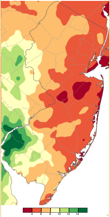
Figure 1. August 2020 precipitation across New Jersey based on a PRISM analysis generated using NWS Cooperative and CoCoRaHS observations (Oregon State University). Areas in red (under 4.00”) received below-average precipitation, while areas in light orange were several inches above normal. Light tan through dark green received twice to over three times normal totals.
Precipitation and Storms
There was a more than five-fold difference in monthly precipitation totals between the driest and wettest location in the state. On the high end, Woodstown (Salem County) was deluged with 15.07”. Other hefty totals included Pennsville (Salem) 13.87”, Mannington (Salem) 13.33”, two South Harrison (Gloucester) locations with 12.46” and 12.41”, Buena Vista (Atlantic) 11.60”, Franklin Township (Gloucester) 11.55”, Greenwich (Hunterdon) 11.04”, and Hamilton (Atlantic) 11.04”. It so happens that another NJ Hamilton in Mercer County had the driest conditions, with two stations coming in with 2.78” and 3.00”. This was followed by Red Bank (Monmouth) with 3.15”, Holmdel (Monmouth) 3.17”, Westfield (Union) 3.19”, Verona (Essex) 3.27”, and Sea Girt (Monmouth) 3.31”.
Rainfall exceeding an inch fell somewhere in NJ on 16 August days. On five of these days more than 3.00” fell at more than one location. The first “one incher” of the month included morning and afternoon storms on the 2nd, mainly in the west central area. Greenwich (Warren) caught 1.95”, Bethlehem Township (Hunterdon) 1.80”, Phillipsburg (Warren) 1.76”, and Holland Township (Hunterdon) 1.54”.
Evening storms on the 3rd brought modest rain but strong winds, especially to the central portion of the state. While not directly associated with forthcoming Tropical Storm Isaias, the south-to-north moving storms were indicative of the energized atmosphere and steering currents that were destined to bring Isaias northward through the region. Berkeley Township (Ocean) was hammered with a 75 mph gust and 0.82” of rain, both tops for the day across NJ. Sea Girt gusted to 42 mph. Reports of downed trees and wires came in from nine counties. By dawn on the 4th TS Isaias had commenced leaving its mark on NJ, first in the form of heavy rain in the south. Strong winds soon arrived as the storm moved through Maryland, Delaware, eastern Pennsylvania, and had its center just clipping western Warren County before heading into New York State. Being closer to the storm’s center, western areas of the state received the heaviest rainfall, while being east (to the right) of the storm’s path brought strong winds to the entire state. Each occurrence is climatologically common when tropical systems reach the middle latitudes.
Rainfall on the 4th totaled an impressive 7.86” in Salem (Salem). More common were five inch totals in Pennsville (5.95”), Bethlehem Township (5.22”), Blairstown (Warren) and White Township (Warren; each 5.14”), and Franklin Township (Hunterdon) 5.13” (Figure 2). Some 31 CoCoRaHS and NJWxNet stations caught from 4.00”–4.99”, 41 from 3.00”–3.99”, 69 from 2.00”–2.99”, and 86 from 1.00”–1.99”. Little rain fell in coastal areas, including just 0.15” in Linwood (Atlantic), 0.17” in West Creek (Ocean), and 0.19” and 0.30” at two Galloway Township (Atlantic) locations.
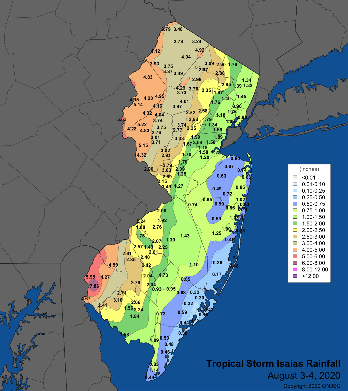
Figure 2. Rainfall from Tropical Storm Isaias on August 3rd-4th, based on NJWxNet, CoCoRaHS, and NWS reports.
Isaias’ winds were the strongest statewide since Sandy in October 2012. Countless trees fell, crushing vehicles and buildings and bringing down power lines. Over 1 million NJ customers lost power, some for upwards of five days. There were no deaths from falling objects, though a death occurred from a live power line during clean up. Fortescue (Cumberland) gusted to 71 mph, eight NJWxNet stations reached 60–69 mph, 12 between 50–59 mph, and 19 from 40–49 mph (Figure 3). Winds were strongest along exposed coastal and inland locations. As tropical systems are wont to do, multiple tornadoes spun up along Isaias’ path. This included two in NJ. Each began as a waterspout, later moving onto land and becoming classified as a tornado. The first came ashore just north of the Strathmere section of Upper Township (Cape May) at 9:45 AM. Heading west, it crossed the Garden State Parkway near mile marker 24 and, with a width of approximately 150 yards, it moved into the Marmora section of Upper Township, dissipating about 10 minutes after beginning its 5.25 mile journey. There was considerable damage to buildings and vehicles, and numerous downed trees and wires. The second tornado began at 10:50 AM as a waterspout in Manahawkin Bay between Ship Bottom and Brant Beach (Ocean). An automobile-mounted camera caught it crossing the Rt. 72 bridge on its way to the mainland in Mud City (Ocean). It had a path length of 3 miles, lasting for about 5 minutes. What is interesting about the EF1 classification given to this storm is that this was not, as usual, determined based on any recognized damage, as none was observed. Rather, the tornado passed over a coastal weather station that recorded a 109 mph gust at 10:53 AM and this was used by the National Weather Service for its rating.
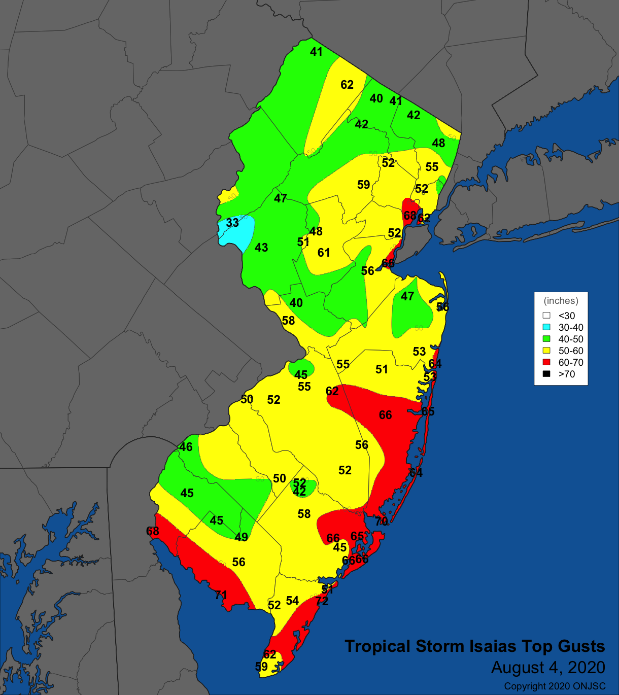
Figure 3. Peak wind gusts from Tropical Storm Isaias on August 4th, based on NJWxNet and NWS reports.
Isolated “run of the mill” storms brought 2.17” to Vineland (Cumberland), 1.73” to Greenwich (Cumberland), and 1.80” at Weymouth (Atlantic) on the 6th. Stronger storms plowed into south Jersey on the evening of the 7th. A gust of 89 mph was recorded at the Upper Deerfield (Cumberland) NJWxNet station, with downed trees and wires reported in the six southernmost counties. Hamilton (Atlantic) caught 5.35”, Franklin Township (Gloucester) 4.37”, Buena Vista 3.67”, Woodstown 3.38”, and Logan Township (Gloucester) 3.35” (Figure 4). This rain, coming on the heels of Isaias’ drenching, led to the breaching of several small dams in the southwest. Scattered 1.00” totals were found elsewhere, though less fell in most central and northern counties.
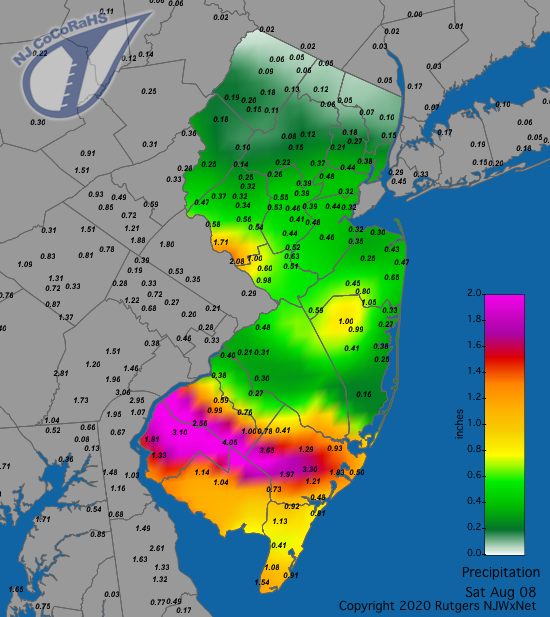
Figure 4. Rainfall from approximately 7AM on August 7th to 7AM on August 8th. Reports are from CoCoRaHS observers.
Afternoon showers on the 11th delivered 1.43” of rain to Howell (Monmouth), 1.37” to Jackson Township (Ocean), and 1.08” at Harrison (Hudson). Thunderstorms awoke people in central and north Jersey on the morning of the 12th, with 1.17” of rain in Stewartsville (Warren) and 1.68” in Haworth (Bergen). Later that afternoon, stronger storms doused the south, with Wenonah (Gloucester) catching 3.14”, Woodland (Burlington) 2.37”, Mansfield (Burlington) 1.85”, and Maurice River Township (Cumberland) 1.82”. Reports of downed trees and wires were received from Bergen, Burlington, Camden, Gloucester, and Ocean counties. The 13th was yet another day with central-area storms in the morning and southern storms in the afternoon. Together, they brought two Middle Township (Cape May) locations 4.14” and 3.74”, Egg Harbor City (Atlantic) stations 2.75” and 2.60”, Dennis Township (Cape May) 2.65”, Princeton (Mercer) 2.28” and 1.87”, and Metuchen (Middlesex) 2.65”. An example of local variations in summer rainfall occurred in 47 square mile Franklin Township (Somerset), with six CoCoRaHS stations reporting 1.69”, 1.06”, 0.52”, 0.35”, 0.29”, and 0.18”. The map of 24 hour rainfall totals through 7AM on the 14th further demonstrates the hit-and-miss characteristic of a number of summer events (Figure 5).
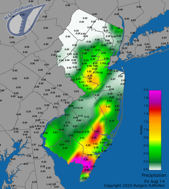
Figure 5. Rainfall from approximately 7AM on August 13th to 7AM on August 14th. Reports are from CoCoRaHS observers.
Showers fell in south Jersey from early to mid-day hours on the 16th. Harvey Cedars (Ocean) saw 1.43”, West Creek 1.41”, Lacey Township (Ocean) 1.40” and 1.25”, and Brigantine (Atlantic) 1.21”. Afternoon and evening storms on the 17th brought down trees and wires in Morris County. A line of storms crossed central and northern areas before dawn on the 18th. The two episodes resulted in Hardyston (Sussex) catching 2.14”, Hawthorne (Passaic) 1.92”, Sayreville (Middlesex) 1.75”, Bloomingdale (Passaic) 1.63”, and two Glen Rock (Bergen) stations with 1.56” and 1.52”. The 19th brought morning storms to central and coastal areas. Monmouth County was hit hardest, with Oceanport receiving 1.78” and a gust of 44 mph. More notably, a 70 yard wide EF0 tornado quickly moved 1.21 miles through the Lincroft section of Middletown (Monmouth) from 9:58–9:59 AM, bringing down trees and causing other scattered damage. Atlantic City Marina (Atlantic) also gusted to 44 mph. Elsewhere, 2.33” fell in Sea Isle City (Cape May), 1.85” in North Wildwood (Cape May), and 1.50” in Ventnor City (Atlantic).
Scattered afternoon showers on the 22nd brought West Caldwell (Essex) 1.07”. The situation was repeated on the 23rd with 2.26” falling in Greenwich (Cumberland), 1.51” in Vineland, and 1.12” at Fairfield Township (Cumberland). Scattered storms on the 25th did not bring any more rainfall to NJ than 0.49” in Haworth but winds gusted to 65 mph at Fortescue and 61 mph at High Point Monument (Sussex). Early-morning showers in northern and central areas on the 27th deposited 1.17” in Branchburg (Somerset) and 0.86” at Clinton (Hunterdon). The main issue was winds bringing down trees and wires in Middlesex, Morris, Union, and Warren counties.
Afternoon and evening storms on the 28th led to a 1.42” total in Pennsauken (Camden), 1.24” at Moorestown (Burlington), and 1.04” at Cream Ridge (Monmouth). Winds gusted to 60 mph at Lower Alloways Creek Township (Salem), 45 mph at Harvey Cedars, and from 42–44 mph at four other locations, with trees and wires down in Burlington, Mercer, Ocean, and Salem counties. Heavy south Jersey rain on the 29th was associated with the remnants of Hurricane Laura, which, several days earlier, made landfall in southwest Louisiana as a category 4 storm. South Harrison was yet again soaked with 4.92”, followed by Washington Township (Gloucester) 4.63”, Pitman (Gloucester) 4.23”, Woodstown 4.05”, Sicklerville (Camden) 3.78”, and Sewell (Gloucester) 3.30”. Nine CoCoRaHS stations caught more than 3.00”, 30 from 2.00”–2.99”, and 51 between 1.00”–1.99” (Figure 6).
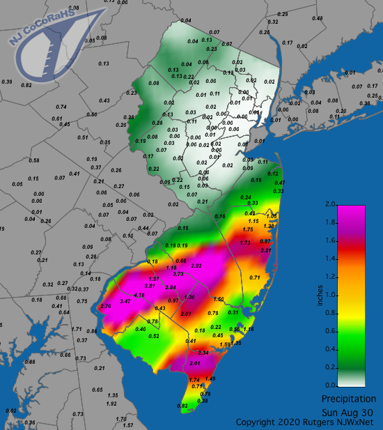
Figure 6. Rainfall from approximately 7AM on August 29th to 7AM on August 30th. This shows the majority of the rainfall associated with the remnants of Hurricane Laura. Reports are from CoCoRaHS observers.
The lowest August barometric pressures recorded in NJ were in the 29.40”–29.50” range, associated with the passage of Isaias on the 4th. Pressures fell to 29.45”–29.55” with the remnants of Laura passing through on the 29th. As with July, the highest August pressures were not that high, ranging from 30.15”–30.20” on the 8th. Aside from the previously mentioned wind gusts exceeding 40 mph, Fortescue reached 49 mph on both the 2nd and 6th. High Point Monument got to 45 mph on the 18th, Lower Alloways Creek Township hit 43 mph on the 23rd, and the Monument to 41 mph on the 27th.
Temperature
Fourteen August days saw the thermometer top out at 90° or higher at one or more NJWxNet station. On half of those days the maximum was from 93°–95° and 28 or more of the 60 stations reached 90°. Days with a state maximum of 90°–92° had 18 or fewer stations make it to 90° and included the 1st, 5th, 9th, 11th, 22nd, 23rd, and 28th. The 2nd found five stations up to 95°, the monthly maximum. 32 others topped out from 90°–94°. The 3rd saw Oceanport and Berkeley Township each reach 93°, with 26 others from 90°–92°. A week later on the 10th, Piney Hollow (Gloucester) got to 95°, with 44 sites from 90°–94°. Harvey Cedars only made it to 80°, for the lowest state maximum. West Deptford (Gloucester) reached 94° on the 12th, when 40 other stations got to 90°–93°. The 24th saw Jersey City (Hudson) as the hotspot at 93° and 37 others from 90°–92°. The following day, Berkeley Township topped out at 93° and 32 other locations got to 90°–92°. Hamilton (Mercer) took top honors at 94° on the 27th, with 49 stations from 90°–93°. The 50 stations over 90° was a monthly maximum, with the “coolest” spot being Vernon Township (Sussex) at a toasty 86°.
Despite well-above-average minimum temperatures across NJ in August, some northwest locations managed to cool off into the 50°s on 16 mornings and twice into the 40°s. Leading the list on all of these mornings was either High Point Monument, the well-known highest location in the state, or valley locations at Pequest (Warren), Sandyston (Sussex), and Walpack (Sussex), with cool air draining into the valleys on calm, clear, and increasingly longer August nights. On occasion, other locations joined them in the 50°s. There were 13 days with the lowest temperature in NJ from 55°–59°, including the 1st, 5th–9th, 15th–16th, 18th, 22nd, 25th, and 27th–28th. Cooler mornings commenced with a 50° low at High Point Monument on the 17th and 18 other NJWxNet locations from 55°–59°. Sandyston and Walpack each fell to 52° on the 19th. The coolest low of the month was 45° at Sandyston on the 20th, with Pequest at 49° and 31 stations from 51°–59°. The next morning Sandyston and Walpack were at 51°, with 23 locations from 53°–59°. Walpack dropped to 51° on the 26th. The 30th found Sandyston and Walpack at 51° and 21 sites from 53°–59°. While 47° minima at Sandyston and Walpack on the 31st were not the lowest of the month, the 38 sites from 50°–59° was the highest such count of August. Despite this, the warmth of the ocean water kept Seaside Heights’ (Ocean) low as mild as 71° and Harvey Cedars 70° on the 31st.
Summer 2020 Overview
Given that each summer month ranked in the top ten for warmth dating back to 1895, it should come as no surprise to anyone spending the 2020 summer in New Jersey that it was one of the warmest on record. And so it was, ranking second warmest, only behind 2010 (Table 2). The 75.3° average was 2.9° above the 1981–2010 normal. The ten warmest summers have all occurred since 1999, with seven of them occurring since 2010. Daytime heat was excessive but not record breaking, with the average summer maximum temperature of 85.5° coming in at 2.6° above normal and ranking 4th warmest behind 2010 (+3.5°), 2016 (+2.8°), and 1999 (+2.7°). It was the elevated nighttime warmth that propelled the overall mean to second place, establishing a new record for the warmest average minimum on record. The 65.1° average was 3.2° above normal and surpassed 2010 by 0.2° for the top spot. The top ten warmest minimums have all occurred since 2005, while six of the ten warmest maximums have occurred since 1999, with others as far back as 1949.
| Rank | Year | Summer Avg. Temp. |
|---|---|---|
| 1 | 2010 | 75.7° |
| 2 | 2020 | 75.3° |
| 3 | 2016 | 74.9° |
| 4 | 2005 | 74.8° |
| 5 | 2011 | 74.6° |
| 6 | 2019 | 74.4° |
| 6 | 2018 | 74.4° |
| 8 | 1999 | 74.3° |
| 9 | 2012 | 74.2° |
| 10 | 2002 | 74.0° |
Table 2. The 10 warmest summers (June–August) across New Jersey since 1895.
The warm nights were indicative of abundant humidity that was reluctant to let the daytime warmth escape the lower atmosphere during nighttime hours. Credible long-term measures of humidity are difficult to find, but just looking at precipitation provides an idea of how generally moist conditions were over the summer. Rainfall averaged 15.93” across NJ during the June–August interval. This is 3.25” above average and ranked 26th wettest of the past 126 summers. Things got off to a slow start, with June rainfall 0.91” below average. However, this turned around in July (+2.22”) and August (+1.94”). The first big break in what was slowly becoming a bit of a drought concern, especially given the overall dryness of the first half of 2020, was provided by the multiple inches of rain throughout the state courtesy of Tropical Storm Fay on July 10th. Making landfall just north of Atlantic City, Fay was rather well behaved, with winds that were not too strong and without a coastal surge. This cannot be said for Tropical Storm Isaias that traveled up the Delaware Valley on August 4th. As recounted earlier in this August/Summer report, heavy rains fell in western sections while damaging winds impacted the entire state. Fortunately, there was not a notable coastal surge.
In addition to these tropical storms, mid-July through August found a number of days with drenching thunderstorms scattered throughout the state. Time and again, in some areas it just seemed to want to rain, especially in the southwest, while storms commonly missed other communities. The wettest CoCoRaHS locations included Franklin Township (Gloucester) 25.42”, Woodstown (Salem) 25.16”, Buena Vista (Atlantic) 23.03”, South Harrison (Gloucester) 22.68”, and Hamilton (Atlantic) 22.38”. Glen Rock (Bergen) was driest with 10.86”, followed by Hamilton (Mercer) 10.93”, Oakland (Bergen) 11.01”, Lawrence Township (Mercer) 11.29”, Denville (Morris) 11.37”, and Stafford Township (Ocean) 11.47”. What a difference a year makes in Stafford, where last summer this community was third wettest in NJ with 23.53” in the rain bucket.
For those seeking more detailed information on 5-minute, hourly, daily, and monthly conditions, please visit the following Office of the NJ State Climatologist's websites:
Rutgers NJ Weather Network
NJ Community Collaborative Rain, Hail and Snow Network
NJ Snow Event Reports
Interested in receiving our monthly summaries at the end of each month? Send us your e-mail address here to join the mailing list.
Past News Stories

