A Transition Month for Sure: October 2020 Recap
New Jersey State Climatologist
Center for Environmental Prediction, School of Environmental and Biological Sciences/NJAES, Rutgers University
November 5, 2020
Overview
As the warmth of summer transitions to the cold of winter, New Jersey weather conditions can vary markedly from week to week. Such was the case during October 2020, with abundant precipitation occurring from the remnants of two hurricanes, an episode of measurable snow in the north, several weeks of quite dry conditions, a number of comfortably warm days, and the first frost and freeze of the season for many locations. Put this all together and October proved to be milder and wetter than normal. The statewide monthly average temperature of 57.2° was 2.7° above the 1981–2010 mean. This ranks as the 18th mildest (tied with 1963 and 1931) over the 126 years extending back to 1895. Southern areas were warmer than northern ones in terms of actual temperature and departure from normal. The 58.8° average in the south was 3.2° above normal and ranked 15th warmest. The north averaged 54.4°, which was 2.0° on the plus side and ranking 27th mildest.
It took a wet final week of the month to push precipitation totals to the plus side of normal. The 5.15” statewide monthly average was 1.26” above normal and ranked as the 24th wettest on record. Somewhat like temperatures, there was north-south disparity. The south averaged 5.36”, which is 1.73” above normal and ranks 20th wettest. The north averaged 4.64”, which is 0.33” above normal and ranks 36th wettest. Dry conditions prevailed, most notably in the northwest, with coastal reaches wettest (Figure 1). Snow fell in the north on the 30th and will be discussed below.
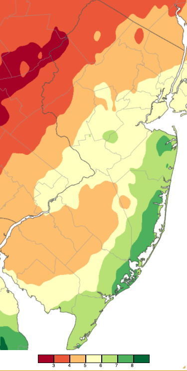
Figure 1. October 2020 precipitation across New Jersey based on a PRISM analysis generated using NWS Cooperative and CoCoRaHS observations (Oregon State University). The two shades of orange/yellow (2.00” to 4.00”) received below-average precipitation, while the lighter shade of orange, yellow and three shades of green (4.00” to 9.00”) were above normal.
Precipitation and Storms
Even the driest locations in October had close-to-average rainfall (and some melted snowfall). Greenwich (Warren County) saw the least at 3.40”. This was followed by Medford (Burlington) at 3.55”, Holland Township (Hunterdon) 3.66”, Monroe (Gloucester) 3.72”, Evesham (Burlington) 3.74”, and Frenchtown (Hunterdon) 3.77”. The wettest location was Eatontown (Monmouth) with 8.88”. Other locations over 8.00” included Lacey Township (Ocean) 8.40”, Long Branch (Monmouth) 8.39”, Berkeley Township (Ocean) 8.32”, Brick Township (Ocean) 8.08”, and Galloway (Atlantic) 8.06”.
The first ten days of October saw just a few days with scattered light showers. The first meaningful event of the month began with some light rain during the afternoon and evening of the 11th. Conditions transitioned to a heavier rain on the 12th, slowly ending with some light rain and drizzle during the morning of the 13th. The rain was associated with the remnants of Hurricane Delta that made US landfall in Louisiana late on the 9th. The system also included some moderate wind gusts along the coast, peaking at 42 mph at Sea Girt (Monmouth) and 40 mph at Atlantic City Marina (Atlantic). Note: wind data were unavailable at often windy Harvey Cedars (Ocean) and Seaside Heights (Ocean) during this event and later in the month. Coastal flooding was in the minor category at some locations on the 12th and 13th. Top rainfall totals included three Stafford Township gauges catching 4.90”, 4.02”, and 3.91”, Lacey Township 4.10”, and Berkeley Township 4.02”. Eleven of the 252 CoCoRaHS reports were between 3.00”–3.99”, 29 from 2.00”–2.99”, and 102 from 1.00”–1.99”. Rockaway Township (Morris) saw the least with 0.36” (Figure 2).
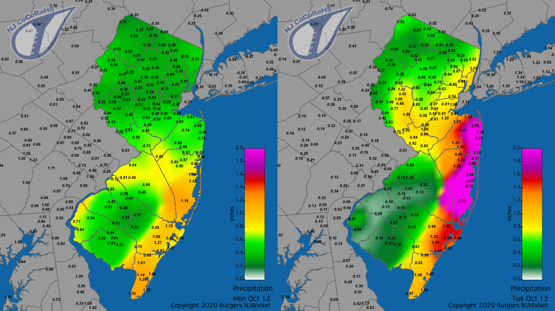
Figure 2. Rainfall from approximately 7AM on October 11th to 7AM on October 12th (left) and 7AM on October 12th to 7AM on October 13th (right). Reports are from CoCoRaHS observers.
Rain returned on the 16th, becoming steadiest in the morning into the afternoon before tapering off during the evening and early on the 17th. Colts Neck (Monmouth) topped the list with 1.81” followed by Hammonton (Atlantic) 1.79”, Howell (Monmouth) 1.78”, and Middletown Township and Jackson Township (Ocean) each with 1.75” (Figure 3). Of the 242 CoCoRaHS reports, 143 were from 1.00”–1.81”. Knowlton (Warren) and Blairstown (Warren) saw the least, each at 0.15”.
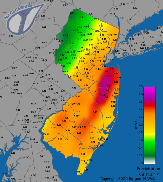
Figure 3. Rainfall from approximately 7AM on October 16th to 7AM on October 17th. Reports are from CoCoRaHS observers.
Light to moderate coastal rain fell on the morning of the 20th. Two Brick Township locations caught 0.66” and 0.56”, with Manasquan (Monmouth) at 0.56” and Hamilton (Atlantic) 0.50”. Again, some modest rain fell early on the 26th, again favoring coastal locations. Eatontown came in with 0.76”, two Ocean Township (Monmouth) sites with 0.75” and 0.63”, and Brick Township 0.72”.
The final episode of inclement October weather was a complex one. A stationary front became established across NJ on the 28th, resulting in some light rain and drizzle in the morning. After a break, rain resumed early on the 29th, becoming steadier and heavier during the morning. This rain continued to be associated with the front but come midday into the afternoon the intensity was enhanced by the arrival of moisture from Post Tropical Storm Zeta. This storm made US landfall, yet again, in Louisiana late the previous afternoon. It made a rapid journey to the Mid Atlantic, the center moving offshore at Cape Henlopen, Delaware, approximate 12 miles south of Cape May (Cape May).
Precipitation continued into midday on the 30th as the low pressure along the front followed Zeta out into the Atlantic. During the early hours of the 30th, enough cold air moved into the region to permit a change over from rain to wet snow, first in the higher elevations of north Jersey and later in lower valleys. There were five reports of snowfall exceeding an inch in Sussex County, including 2.7” at both High Point and Highland Lakes, 2.5”, 1.6” at two Sparta locations, and 1.2” in Vernon Township (Figure 4). Amounts under an inch were observed at several locations in Sussex, Warren, and Morris counties, while flakes flew but did not accumulate at other locations in the north.
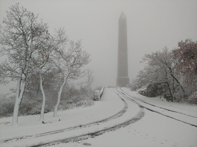
Figure 4. A snowy scene at High Point Monument (Sussex) on the morning of October 30th where 2.7” of snow fell (courtesy of Sean Robert).
When all was said and done, this complex, long-lived event brought impressive totals of rain and melted snow throughout NJ. Figure 5 shows totals for a 24-hour period encompassing the bulk of the precipitation, though a bit more fell in the hours preceding and following the map period. A statewide soaking is evident, as the lowest total is 1.67” in Medford. Not all that far from Medford, Brigantine (Atlantic) received the most with 4.06”. Next heaviest totals were found in Somers Point (Atlantic) 3.91”, Absecon (Atlantic) 3.61”, and Woodbine (Cape May) 3.60”. Of 247 CoCoRaHS reports, 17 ranged from 3.00”–3.99”, 201 from 2.00”–2.99”, and 28 from 1.67”–1.99”.
There was not a lot of wind associated with this event. Gusts reached 45 mph at Sea Girt and 43 mph in Point Pleasant (Ocean) on the 29th, and 44 mph at Atlantic City Marina and 41 mph in Sea Girt on the 30th. Minor to borderline moderate coastal flooding occurred at some locations, helped along by the approaching second full moon of the month on the 31st.
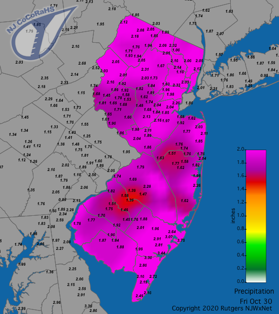
Figure 5. Rainfall from approximately 7AM on October 29th to 7AM on October 30th. Reports are from CoCoRaHS observers.
Aside from the three gusty days on the 12th, 29th, and 30th mentioned above, the 7th saw gusts to 52 mph at High Point Monument, 51 mph in Vernon Township, and 42 mph at Wantage (Sussex). The Monument gusted to 43 mph on the 8th. No other days or locations saw gusts up to 40 mph. The lowest barometric pressure of the month was associated with the passage of Zeta on the 29th. Six NJWxNet southern stations closest to the post tropical storm saw the pressure bottom out from 29.27”–29.35”, while elsewhere readings were from 29.36” to 29.61”, the latter value up north in Charlotteburg (Morris). Just two days later, the highest pressures of the month ranged from 30.50”–30.60”.
Temperature
While there was no excessive heat during the month, unlike what was seen early last October, daytime highs were often above 70°. This made for frequently comfortable conditions. Nine of those days discussed below had highs at one or more NJWxNet station at or above 75°. The first was on the 1st with Cape May Court House (Cape May), Oswego Lake (Burlington), and West Creek (Ocean) all up to 78°, with 24 of the 64 WxNet stations between 75°–77°. The 7th saw Oswego Lake at 80° and 13 other locations from 75°–79°. Cape May Court House (Cape May) reached 77° and Mannington (Salem) 76° on the 10th. Uniform conditions prevailed on the 15th, with five stations at 77° and 32 at 75° or 76°.
A warm five days commenced on the 20th, with Piney Hollow (Gloucester) at 77° and Red Lion (Burlington) 76°. Moorestown (Burlington) made it up to 81° on the 21st, with five stations at 80°, and 26 from 75°–79°. That day, High Point Monument only made it up to 60°. The warmest day of the month was the 22nd, with Piney Hollow peaking at 82°, Vineland (Cumberland), Upper Deerfield (Cumberland), and Mannington each at 81°, three stations at 80°, and 25 others topping off from 75°–79°. The warmth continued on the 23rd with Mannington reaching 76°, and on the 24th with Lower Alloways Creek Township (Salem) up to 78° and Hopewell Township (Mercer) and Vineland each rising to 77°.
On the cold side of the ledger, eight October days saw low temperatures drop to 35° or lower at one or more NJWxNet location, with four days having stations below freezing. The 4th saw Basking Ridge (Somerset), Pequest (Warren), and Sandyston (Sussex) down to 34°, with the same minimum at Hopewell Township, Berkeley Township, and Oswego Lake on the 9th. Sandyston fell to 35° on the 14th. By midnight on the 17th, evening lows had fallen to 29° at Walpack (Sussex), 31° at Sandyston, and 32° in Basking Ridge and Pequest. The morning of the 18th brought a more widespread freeze than had been experienced during the four nights of freezing conditions from September 19th–22nd. Walpack fell to 26°, Pequest and Sandyston each to 27°, and 14 stations from 29°–32°. Frost occurred in these areas and others where temperatures at six feet above cooler frosty surfaces were within several degrees of freezing (Figure 6).
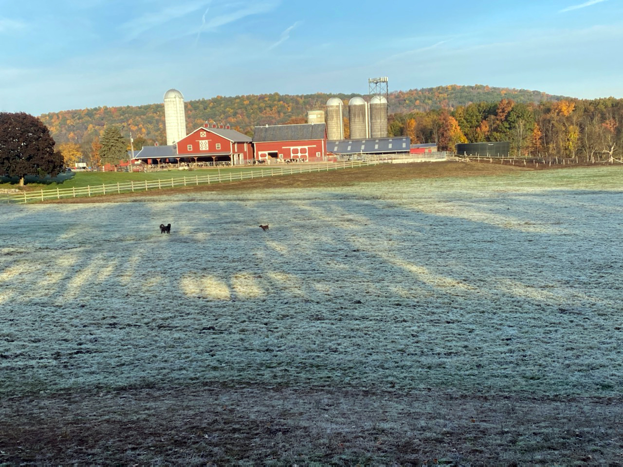
Figure 6. A frosty Sussex (Sussex) farm field along with peak foliage on the morning of October 18th (courtesy of N. Stefano).
Following the late-month warm spell, cool conditions returned to Walpack and High Point Monument on the 25th, with each down to 33°. The 30th found minimum temperatures falling to 26° at Walpack, 27° at Sandyston and High Point Monument, 11 stations from 29°–32°, and 12 from 33°–35°. The growing season ended for the bulk of New Jersey on the 31st, as the thermometer plunged to 20° at Walpack, Sandyston 22°, and Pequest and High Point (Sussex) each at 23°. Lows of 24°–30° were reached at 31 other locations and from 30°–32° at 17 others. Even some urban locations reached the freezing point, an example being Newark Airport (station located in Union) at 32°. Some coastal locations escaped a freeze, with Atlantic City Marina the mildest at 38°.
For those seeking more detailed information on 5-minute, hourly, daily, and monthly conditions, please visit the following Office of the NJ State Climatologist's websites:
Rutgers NJ Weather Network
NJ Community Collaborative Rain, Hail and Snow Network
NJ Snow Event Reports
Interested in receiving our monthly summaries at the end of each month? Send us your e-mail address here to join the mailing list.
Past News Stories

