Blown Away: April 2020 Recap
New Jersey State Climatologist
Center for Environmental Prediction, School of Environmental and Biological Sciences/NJAES, Rutgers University
May 5, 2020
Overview
If you have a sense that April was unusually windy, you are certainly not alone. While long-term wind observations are few across the Garden State and those available suffer from inconsistencies in instrumentation and location, seat-of-the-pants judgment tells us that plenty of air raced crossed the state throughout the month. In fact, the wind gusted to 40 mph or higher at one or more NJWxNet station on 12 days. Of those, seven had gusts from 50–59 mph and an impressive four gusted over 60 mph. The highest network gust of 76 mph occurred at Sea Girt (Monmouth County) on the 21st. There were also reports from other seemingly reliable stations of gusts as high as 82 mph at Island Beach State Park (Ocean) on the 13th.
April precipitation achieved a statewide average of 3.92”. This is 0.07” below the 1981–2010 mean, but given the skewness of the distribution of April rainfall over the past 126 years, it ranks as the 45th wettest. Despite Morris County stations having the highest monthly totals, overall, the north part of the state was driest. The mean of 3.66” was 0.54” below normal and is the 59th driest (68th wettest). The south averaged 4.07”, which is 0.21” above normal and is 40th wettest. The narrow coastal region averaged 4.16”, which is 0.33” above normal and ranks 39th wettest.
Traces of snow, sleet, and graupel were observed at a number of locations around NJ in April, though any measurable snowfall was limited to some northern locations, mainly at higher elevations. The statewide average was a trace, closing the books on the 2019–2020 snow season as the 3rd least snowy since 1895 with an average of 4.7”. The north averaged 0.1” in April, with the central and south regions coming in with a trace. The complete seasonal snow summary can be found here.
Temperature-wise, it was the first month averaging below normal since November 2019 and only the 4th such month of the past 24. The 48.7° average was 2.2° below normal and ties with several other years as the 47th coolest since 1895. The north averaged 46.6°, which is 2.8° below normal and is 35th coolest, the south was 50.0°, which is 1.9° below normal and tied for 55th coolest, and the coast averaged 49.5°, which is 1.5° below normal and tied for 62nd coolest. The average statewide high temperature of 58.6° was 3.4° below average, tied for 32nd coolest on record. This was indicative of the frequent cloud cover keeping the increasingly strong spring solar radiation at bay. The average minimum of 38.7° was 1.1° below average and ranked 59th warmest (65th coolest).
An interesting temperature factoid finds this April being only 2.6° milder than March. This is the third closest April has come to being cooler than March. Previously, 1946 had a difference of only 2.2° and in 1898 the difference was 2.4°. The largest March to April difference was 23.0° in 1960. The closeness this year was due to a cool April and the 6th mildest March, while 1960 had the second coldest March on record and the 9th mildest April. The long-term average difference between the months is 10.1°, which is the second greatest over the course of the year, only exceeded by the 11.3° difference between September and October, with November to December third largest at 10.0°.
Precipitation and Storms
As mentioned previously, Morris County was the center of the heaviest April precipitation totals. Mine Hill caught 5.55”, Rockaway 5.42”, Chester 5.31”, and Mount Arlington 5.17”. Bloomingdale (Passaic) came in with 5.38”. On the low end, Franklin Township (Gloucester) received 3.00”, Andover (Sussex) 3.11”, three Blairstown (Warren) stations had 3.11”, 3.22”, and 3.36”, Cranford (Union) 3.28”, and Westfield (Union) 3.29”. Monthly snowfall was 1.8” at High Point (Sussex), followed by 1.0” in Wantage (Sussex), Jefferson Township (Morris) and Sparta (Sussex) each with 0.5”, and Hardyston (Sussex) 0.2”.
The first week of April found several days with scattered showers generally totaling no more than 0.20” at any particular location on any day. Early morning thunderstorms and showers on the 8th deposited as much as 0.86” in Frenchtown (Hunterdon), Montgomery (Somerset) 0.72”, Princeton (Mercer) 0.70”, and Flemington (Hunterdon) 0.69”. The heaviest totals were found between Interstates 195 and 78, while small hail was reported in Gloucester County. Along Delaware Bay, winds gusted to 43 mph in Lower Alloways Creek Township (LACT; Salem) and 42 mph at Fortescue (Cumberland).
A lightning strike on the 8th ignited a wildfire in the Millville Wildlife Management Area in Downe Township (Cumberland). The fire burned approximately 1500 acres of forest before being fully contained late on the 10th. No injuries or structural damage were reported.
An early-afternoon squall line crossed the state from west to east on the 9th. The rapid advance of the line limited rainfall totals to no more than 0.55” at Brigantine (Atlantic), 0.41” in Linwood (Atlantic), and 0.41” and 0.35” at two locations in Woodbine (Cape May). Pea-size (1/4”) hail was reported in Monmouth County, while the big story was the wind. Gusts of 66 mph were recorded at High Point Monument (HPM; Sussex) and Seaside Heights (Ocean), LACT 63 mph, Harvey Cedars (Ocean) 61 mph, with eight NJWxNet stations gusting between 50–59 mph and 22 from 40–49 mph. Other gust reports included 71 mph at Barnegat Light (Ocean), Linden (Union) 66 mph, and Pomona (Atlantic) 62 mph. Reports of structural damage, toppled trees, and scattered power outages were common around the state.
A blustery 10th saw Jefferson Township pick up 0.5” of early-morning snow with a number of locations in north seeing the ground briefly snow-covered (Figure 1). North and central areas experienced brief squalls of snow or graupel during the daytime hours. Winds continued to howl, gusting to 61 mph at LACT, 59 mph at HPM and Upper Deerfield (Cumberland), 50–58 mph at eight locations, and 40–49 mph at 22 other NJWxNet stations.
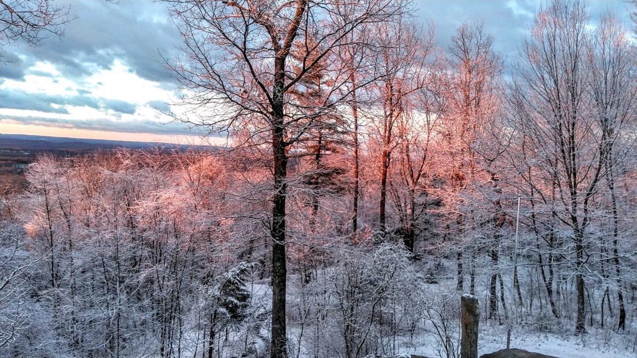
Figure 1. An early morning April 10th photo at Sunrise Mountain in Wantage. Photo courtesy of Elizabeth Claire Kelly.
The strongest storm of the month began late on the 12th and continued until the early evening on the 13th. Rainfall totals ran as high as 2.81” and 2.73” at two Randolph (Morris) stations, followed by Bloomingdale 2.72”, Mount Arlington 2.63”, Mine Hill 2.61” and 2.50” (two locations), Rockaway 2.60”, and Roxbury (Morris) 2.58”. The Morris County maximum is seen on the two maps showing CoCoRaHS reports for the 24-hour intervals ending on the mornings of the 13th and 14th (Figure 2). Of the 244 CoCoRaHS stations reporting the event, 55 received from 2.00”–2.82”, 181 between 1.00”–1.99”, with a low total of 0.85” in Fredon (Sussex). A major aspect of this storm was, once again, the wind. What was likely a gravity wave brought strong winds down to the surface from several thousand feet aloft. This resulted in damaging gusts along the south coast that reached 82 mph at Island Beach State Park, 81 mph at Barnegat Light and Mystic Islands (Ocean), Harvey Cedars 67 mph, Atlantic City Marina (Atlantic) 63 mph, Mullica (Atlantic) 62 mph, and Woodbine 61 mph. A dozen other NJWxNet stations reached 50–58 mph and 19 from 40–49 mph (Figure 3). Structural damage, downed trees, and power outages were reported.
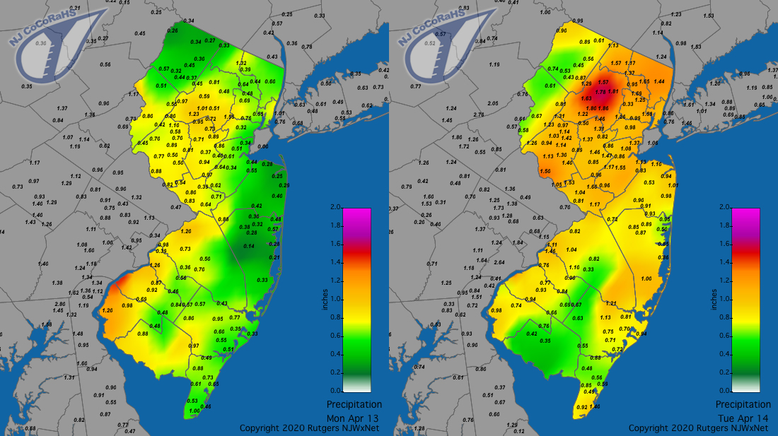
Figure 2. Rainfall from approximately 7AM on April 12th to 7AM on April 13th (left) and from 7AM on April 13th to 7AM on April 14th (right). Reports are from CoCoRaHS observers.
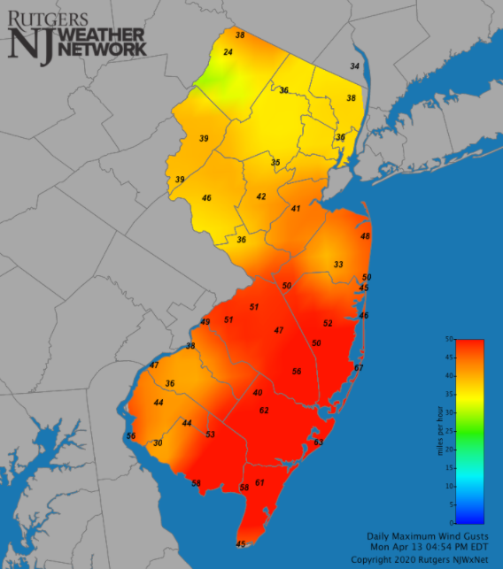
Figure 3. Maximum wind gusts at NJWxNet stations on April 13th.
The 16th found snow flurries in the southwest early in the day and in northern and central regions in the early evening. Rain next arrived late during the evening of the 17th, persisting until mid-morning on the 18th. Totals were largest north of Interstate 78, with two West Milford (Passaic) stations at 0.63” and 0.62”, Jefferson Township 0.60”, and Montague (Sussex) 0.59”. Less than 0.25” of rain fell further south. High Point Ranger Station (Sussex) picked up 1.3” of snow, while 1.0” accumulated at an elevation of 1,000’ in Wantage.
Following late-morning showers on the 21st, an early-afternoon squall line raced across NJ, bringing brief heavy rain, reports of rice- to pea-size (1/4”) hail in counties throughout the state, and, again, damaging wind. Princeton and Toms River (Ocean) each reported the most rain with 0.42”, while both Denville (Morris) and Hackettstown (Warren) picked up 0.38”. Most locations caught 0.15”–0.25”. A waterspout in Barnegat Bay traveled east and made landfall in Normandy Beach (Ocean), thus transitioning to a tornado. Rated an EF0, the twister traveled about 0.4 mi before dissipating over the Atlantic Ocean as a waterspout. There were other reports of waterspouts further up the coast. Wind gusts reached 76 mph in Sea Girt (Monmouth), West Cape May (Cape May) 69 mph, Logan Township (Gloucester) 66 mph, and Pomona 60 mph. Four NJWxNet stations gusted between 50–59 mph and 14 from 40–49 mph (Figure 4). Yet again, there was scattered structural damage, trees felled, and power outages.
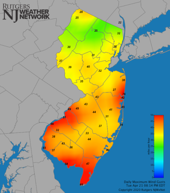
Figure 4. Maximum wind gusts at NJWxNet stations on April 21st.
The second-largest rain event of April began late on the 23rd, lasting into the early evening of the 24th. Gratefully, this was not accompanied by strong winds. Linwood’s 2.44” took top honors, followed by Sea Isle City (Cape May) 1.93”, three Woodbine stations with 1.89”, 1.87”, and 1.83”, two Middle Township (Cape May) reports of 1.84” and 1.65”, and Absecon (Atlantic) 1.83”. Of the 245 CoCoRaHS reports, 106 came in between 1.00”–1.93” and 138 from 0.50”–0.99” (Figure 5). Montague only saw 0.44”.
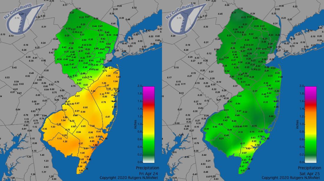
Figure 5. Rainfall from approximately 7AM on April 23rd to 7AM on April 24th (left) and from 7AM on April 24th to 7AM on April 25th (right). Reports are from CoCoRaHS observers.
A raw, rather windy 26th brought 0.78” to Rockaway, 0.68” and 0.62” to two West Milford locations, 0.61” to Washington Township (Warren), and 0.56” in Chester (Morris). As happens on occasion, some heavy rain fell on the last day of the month, with the vast majority falling after morning reports were filed by most National Weather Service Cooperative and CoCoRaHS observers. Thus the afternoon and evening rain that fell is counted as a May 1 value at most stations and has not been factored into the monthly station totals listed earlier in this report. Nor are most of these reports included in the monthly statewide totals, though there are a minority of stations that report in the evening or at midnight (e.g., NWS airport stations), causing some minor weight to the statewide totals to come from this event. A full accounting will be found in the May report, but suffice it to say that as much as 2.19” fell in Washington Township (Morris), 2.17” at Oxford (Warren), and 2.15” at Hackettstown, with the northwest coming in well ahead of most other areas. Winds gusted strongly on the 30th, with a 56 mph peak at HPM, Lyndhurst (Bergen) 54 mph, Logan Township 52 mph, and 27 NJWxNet stations between 40–49 mph (Figure 6).
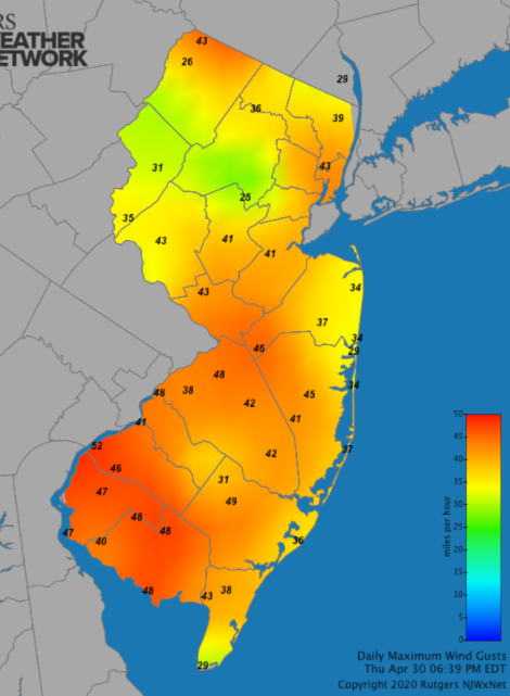
Figure 6. Maximum wind gusts at NJWxNet stations on April 30th.
The highest barometric pressures of the month occurred on the 17th, ranging from 30.30”–30.40” around the state. The lowest pressures were between 29.10”–29.25” on the 9th. There were six days not previously mentioned when winds at one or more NJWxNet stations gusted to 40 mph or higher. They included the 2nd with HPM at 52 mph, LACT 46 mph, and six stations from 40–43 mph. HPM reached 46 mph and Vineland (Cumberland) 40 mph on the 3rd. HPM hit 40 mph on the 11th, 41 mph on the 15th, and 40 mph on the 16th. HPM reached 51 mph on the 22nd, when Mullica hit 42 mph.
Temperature
Daily maximum temperatures equaled or exceeded 70° at a number of the 62 NJWxNet stations on seven April days, while on five others, the thermometer reached 68° or 69° at multiple sites. The first 70° day was the 5th with Sewell (Gloucester) up to 72°, while 44 stations were between 65°–69°. The 8th was the warmest day of the month, with the 76° mark reached at Cape May Court House (Cape May), Mansfield (Burlington), Vineland, and Woodbine. Some 34 other stations topped out from 70°–75°, while HPM only made it to 57°. The 9th found Egg Harbor Township (Atlantic) and Woodbine at 73°, 16 other stations from 70°–72°, and again HPM coolest at 49°.
Sicklerville (Camden) rose to 72° and 14 stations from 70°–71° on the 12th. The diurnal temperature range that day was as large as 46° (67°/21°) at Walpack (Sussex) and 45° (70°/25°) in Hopewell Township (Mercer). Five stations made it to 73° on the 13th, followed by 11 from 70°–72°. 70° weather did not return to the Garden State until the 29th with LACT up to 72° and 14 sites from 65°–69°. Five locations reached 70° on the 30th, with 32 others topping out from 65°–69°.
Eighteen April days found at least one NJWxNet station recording a minimum of 32° or lower. On eleven of those days the state low was from 26°–32° (April 1, 2, 5, 7, 10, 11, 15, 18, 20, 28, 29). The first of the 25° or colder mornings did not occur until the 12th, when Walpack dipped to 21° with 33 of the 62 network stations between 25°–32°. Harvey Cedars and Atlantic City Marina only dropped to 46°. Walpack reached 25° and 20 stations from 26°–32° on the 16th. The morning of the 17th was exceptionally cold for mid-April. Walpack bottomed out at 20° and Berkeley Township (Ocean), Hopewell Township, Pequest (Warren), and Sandyston (Sussex) chilled to 21°, while 13 stations were from 22°–25° and 36 from 26°–32°. Only seven NJWxNet stations remained above freezing, the mildest being 37° at Atlantic City Marina. An estimated 25% of the state’s blueberry crop was damaged by the cold. The depth of the cold is illustrated by the 27° minimum at New Brunswick (Middlesex). While this location, with over a century of observations, commonly drops near or below freezing as late as mid-April, the 27° minimum was 1° above the record low for the date (1928) and only two other days after the 17th have ever been colder. Those dates were the 18th (26°) and 20th (25°), each in 1926.
The 19th gave the 17th a run for its money with Hopewell Township down to 22°, Pequest and Berkeley Township each 23°, and 43 stations from 24°–32°. A run of three days finished up the month’s coldest mornings with Walpack being the only location at or below 25° each day. It fell to 24° on the 21st with 11 stations from 27°–32°, 25° on the 22nd with 15 sites from 26°–32°, and 23° on the 23rd with 25 locations from 26°–32°.
Seven NJWxNet stations failed to record a freezing temperature in April. Four of these locations last reached the freezing mark on March 1st, namely Atlantic City Marina, Harvey Cedars, Seaside Heights, and Lower Alloways Creek Township. These coastal locations were joined by Fortescue (3/8), Pennsauken (Camden; 3/8), and Lyndhurst (3/16). It is quite unusual to have what is likely the last freeze at these stations occur so early in the spring season.
Rays of hope
I thought it might be welcome to end this report of rather dismal spring weather over the course of these trying times with a burst of sunshine. The afternoon of the 30th was generally cloudy and damp, but at times the sky brightened a bit. As the map of solar radiation and the accompanying visible satellite image shows, the sun shined brightly for a brief while in the vicinity of Atlantic City (Figure 7). Elsewhere, clouds thinned enough to raise values a bit, though the far north saw thick clouds locked in throughout the day.
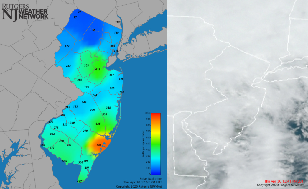
Figure 7. Solar radiation at 12:52PM (left) and cloud cover from a visible satellite image at 12:41PM (right) on April 30th. Radiation observations from the NJWxNet and satellite image from NOAA.
For those seeking more detailed information on 5-minute, hourly, daily, and monthly conditions, please visit the following Office of the NJ State Climatologist's websites:
Rutgers NJ Weather Network
NJ Community Collaborative Rain, Hail and Snow Network
NJ Snow Event Reports
Interested in receiving our monthly summaries at the end of each month? Send us your e-mail address here to join the mailing list.
Past News Stories

