Bitter Cold: February 2015 Recap and Winter 2014-2015 Review
New Jersey State Climatologist
Center for Environmental Prediction, School of Environmental and Biological Sciences/NJAES, Rutgers University
March 6, 2015
February Overview
It will come as no surprise to those reading this report that February 2015 was one of the coldest months on record in the Garden State. The average temperature of 22.0° (11.8° below average) made this month the 3rd coldest February and 6th coldest (tied) of any month since statewide records commenced in 1895. Table 1 lists the ten coldest Februaries, based on observations gathered from several dozen stations throughout NJ. Colder Januaries include 1918 (19.9°), 1977 (20.2°), and 1912 (21.9°), with 1940 equal to this past February.
| Rank | Year | Feb. Avg. Temp. |
|---|---|---|
| 1 | 1934 | 17.9° |
| 2 | 1979 | 21.9° |
| 3 | 2015 | 22.0° |
| 4 | 1905 | 22.7° |
| 5 | 1895 | 22.9° |
| 6 | 1907 | 23.0° |
| 7 | 1978 | 23.2° |
| 8 | 1936 | 24.0° |
| 9 | 1904 | 24.2° |
| 10 | 1901 | 24.7° |
Table 1. Top 10 coldest NJ Februaries since 1895.
Statewide, melted snow, ice, freezing rain, and plain rain amounted to 2.34". This was 0.52" below average and ranks as the 32nd driest February. There were five events where snow fell to a depth of 2" or more at one or more locations, however there was no statewide "blockbuster" storm. NJ February snowfall averaged 12.3", which is 4.2" above normal. The northern third of the state averaged 16.3" (+6.2"), central area 12.6" (+3.6"), and southern third 10.1" (+3.5"). The ground remained snow covered throughout the month in northern and central regions, consistently at a depth exceeding 10" in the north and closer to 5" in central areas.
Temperature
Along with the persistent cold there were some exceedingly cold mornings and some exceptional wind chill values. The thermometer dipped below zero on 18 days at Walpack (Sussex County), bottoming out at -20° on the 24th. Historical records show that only on February 28, 1934, was a colder temperature observed in NJ later in the season, that being -23° at Layton (Sussex). Most locations outside of urban centers or immediately adjacent to the coast saw the thermometer dip below zero on several mornings, most notably the 20th (especially in the south) and 24th (in the north). Along with the 18 subzero days at Walpack were two other days where this location did not reach that level but other stations did. Table 2 provides a sampling of coldest February monthly minimums around NJ.
|
Community |
County |
Minimum |
|
Walpack |
Sussex |
-20° |
|
Pequest |
Warren |
-15° |
|
Kingwood |
Hunterdon |
-14° |
|
Basking Ridge |
Somerset |
-13° |
|
Charlotteburg Res. |
Passaic |
-12° |
|
Berkeley Twp. |
Ocean |
-12° |
|
Hope |
Warren |
-11° |
|
High Point |
Sussex |
-11° |
|
High Point Monument |
Sussex |
-10° |
|
Oswego Lake |
Burlington |
-9° |
|
Stewartsville |
Warren |
-7° |
|
Woodbine |
Cape May |
-7° |
|
Howell |
Monmouth |
-7° |
|
Hillsborough |
Somerset |
-6° |
|
Haworth |
Bergen |
-5° |
|
Clayton |
Gloucester |
-4° |
|
Sicklerville |
Camden |
-4° |
|
Jersey City |
Hudson |
0° |
|
Sea Girt |
Monmouth |
1° |
|
Atlantic City Marina |
Atlantic |
3° |
|
West Cape May |
Cape May |
5° |
Table 2. A sampling of February 2015 extreme daily minimum temperatures around NJ. Observations are from NJ Weather and Climate Network stations.
Wind chills on multiple occasions dipped below zero throughout the state, at times to between -10° and -20°. The most brutal wind chill conditions were observed at High Point Monument (Sussex), where below-zero temperatures and wind speeds exceeding 40 mph resulted in wind chills of -41° on the 20th (-14° temperature and sustained 35 mph wind) and -40° on the 15th and 16th. The wind chill bottomed out at -20° to -34° at High Point Monument on 11 other days.
A breakdown of all subzero days follows, including mention of any station reaching -10° or colder during the month. Pequest (Warren) started things off on the 1st at -1°. The 3rd found Walpack at -7 and Pequest next coldest at 1°, while on the 4th Walpack was -10° and Pequest again next at 1°. Such disparities were found at times this month, since the valley in which Walpack sits is a special location for cold air drainage on clear, calm nights with deep snow cover. Walpack was -6° on the 5th with High Point Monument next at 2°. The 6th saw Walpack down to -16°, with Pequest at -9° and Hackettstown (Warren) and Hope (Warren) both at -4°. Walpack was -6° and Pequest 1° on the 7th. Once the thermal inversion that helps make Walpack so cold during the nighttime hours disappears, temperatures can rise quite a bit during the day. In fact, on six February days the diurnal temperature range was 40° or greater. This includes the 28th when the morning low was -15° and daytime high 33°, a most impressive 48° range.
Subzero cold returned from the 13th–21st, and all but two other days through month's end. Walpack reached -8° on the 13th with High Point Monument and High Point (Sussex) both -3°. Walpack was -12°, Pequest -5°, and Charlotteburg (Passaic) and Hope all at -4° on the 14th. Cold air flowing into NJ on the 15th brought colder temperatures to High Point Monument (-8°) and High Point (-7°) than to Walpack (-6°) on the 15th. Walpack was -12°, the Monument -9°, and High Point and Pequest -8° on the 16th. Walpack dropped to -4° and Kingwood (Hunterdon) and Pequest both to -1° on the 17th. The minimum was -16° at Walpack on the 18th, with Pequest at -10° and four stations at -7°. High Point Monument and High Point were, respectively, -5° and -4° on the 19th. The 20th saw a low of -13° at Walpack, -10° at the Monument, and -9° at three stations.
The 21st saw 31 of the 53 NJ Weather and Climate Network stations dip from -1° to -17°, with Walpack taking "low honors". Atlantic City Marina (Atlantic) and West Cape May (Cape May) were "mildest" at 13° and 11°, respectively. Berkeley Township (Ocean) in the southern Pinelands fell to -12° and Basking Ridge (Somerset) to -11°.
The 23rd saw Walpack at -11° and Pequest -6°. On the 24th, along with Walpack's -20°, 26 other stations fell to between -1° and -15°. Pequest was the coldest of that group, with Kingwood at -14° and Basking Ridge -13°. West Cape May only fell to 9°. Walpack and Pequest were -1° on the 25th, Walpack -2° on the 27th, and Walpack -15°, Pequest -5°, and Hope -3° on the 28th.
Just three February days saw high temperatures of 50° or higher somewhere in NJ and nine days had at least some stations peaking in the 40°s. Meanwhile, there were seven days when the entire state remained below the freezing point. The 1st saw Egg Harbor Township (Atlantic) get to 41° and four other stations to 40°. Greenwich (Cumberland), Hammonton (Atlantic), Upper Deerfield (Cumberland), and Woodstown (Salem) reached 51° on the 2nd, yet High Point Monument only rose to 23°. Greenwich, Howell (Monmouth), and Piney Hollow (Gloucester) reached 49° on the 4th, with 33 other NJWxNet stations between 40°–49° on a day that began at -10° in Walpack. Cape May Courthouse (Cape May) peaked at 46° on the 5th, with five stations at this value on the 7th.
The 8th was the mildest day of February. Piney Hollow peaked at 62° and Woodbine (Cape May) at 60°. 17 stations saw maximums from 50°–59° and 20 between 40°–49°, yet High Point Monument only made it to 31°. Bivalve (Cumberland) and Dennis (Cape May) reached 41° on the 9th, seven stations were 42° on the 10th, and Greenwich, Dennis, and Piney Hollow were 42° on the 11th. The 12th saw Mansfield (Burlington) at 42°, nine stations at 41°, and 16 at 40°. The next mild day was the 22nd, with Cream Ridge (Monmouth) rising to 50° and 50 stations topping out in the 40°s. High Point experienced its only above-freezing maximum of the month at 37°. This was part of a 54 day run, extending back to January 6 and going through February 28, where the thermometer only rose above freezing twice (37° on January 18th was the other day) at this "lofty" location. Meanwhile in West Cape May, 37 of the 54 days saw maximums exceeding freezing. The 25th saw Mansfield, Sicklerville (Camden), and Woodbine get to 40°.
Precipitation and storms
As mentioned above, February was precipitation was on the dry side. Rain and melted snow/ice at individual locations amounted to, at best, 3.56" in Freehold (Monmouth), Howell 3.40", Jackson (Ocean) 3.39", Belmar (Monmouth) 3.35", and Fair Haven (Monmouth) 3.12". On the low side, Peapack-Gladstone (Somerset) only saw 1.29", Lebanon (Hunterdon) 1.34", Long Hill Township (Morris) 1.42", Washington (Warren) 1.55", and Roxbury Township (Morris) 1.56".
The snowiest locations included Freehold 20.9", Jefferson Township (Morris) 20.6", Holland (Hunterdon) 19.9", Oakland (Bergen) 19.6" and 17.2" (two stations), Wantage 19.4", and Rockaway Township (Morris) 19.2".
There were five significant precipitation events during February. The first was from late on the 1st through the evening of the 2nd. There was mostly snow in the north, mixed precipitation in the central region, and mostly rain in the south. Rain and melted snow/ice amounted to as much as 1.77" in Cranford (Union), Eatontown (Monmouth) 1.75", Howell 1.67", Freehold 1.66", Belmar 1.63", and Denville (Morris) 1.60". Of almost 200 CoCoRaHS reports, 134 saw between 1.00" and 1.77" and 50 from 0.50"–0.99". Snowfall was as deep as 12.0" in West Milford (Passaic), Mahwah (Bergen) 10.6", Wantage 10.5", Kinnelon (Morris) 9.0", and Hardwick (Warren) 8.0". North of I-80, 6"–10" were common totals, tapering to 1"–3" in central NJ, and little in the southern third of the state.
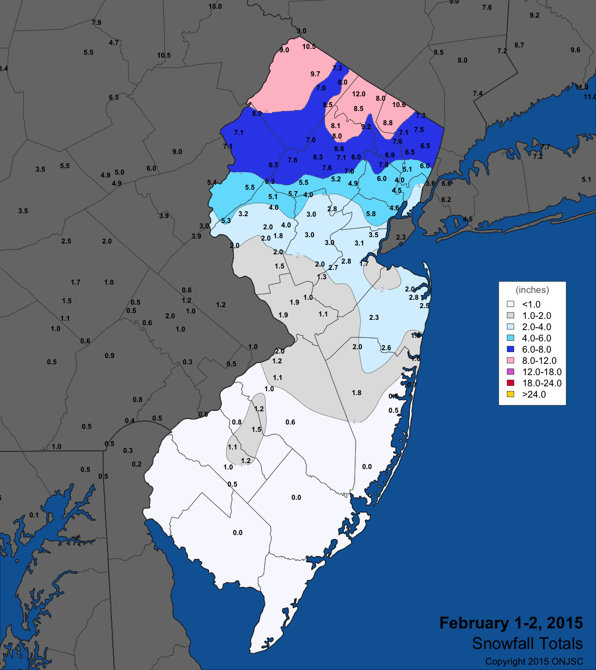
Figure 1. February 2nd-3rd snowfall totals from National Weather Service (NWS) Cooperative observers and spotters, and CoCoRaHS volunteers. For larger view, click here.
Conditions were quite quiet until the 14th when an afternoon event that lasted to the pre-dawn hours of the 15th brought snow throughout NJ. The Monmouth/Ocean county region saw the most with 3"–7" and Camden/Gloucester next at 3"–4". Elsewhere 1"–3" reports were common. Lavallette (Ocean) received 7.6", Red Bank (Monmouth) 7.0", Ocean Township (Ocean) 6.0", and Pitman (Gloucester) 5.0". Melted totals were as high as 0.48" in Lavallette, 0.42" in Freehold, and 0.41" at Clinton (Hunterdon).
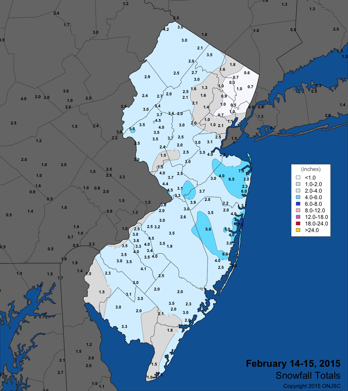
Figure 2. February 14th-15th snowfall totals from National Weather Service (NWS) Cooperative observers and spotters, and CoCoRaHS volunteers. For larger view, click here.
Light, powdery snow fell late on the 16th into the morning of the 17th. South of I-78, totals mainly ranged from 3"–6", while to the north 1"–3" was measured. In counties where 6" or more was measured, the top values included 7.0" in Cape May (Cape May), Neptune (Monmouth) 7.0", McGuire (Burlington) 6.5", Egg Harbor City (Atlantic) 6.1", and 6.0" totals in Pittsgrove (Salem), Sewell (Gloucester), and Jackson. Top liquid totals were found in the Cape May communities of Wildwood Crest (0.54"), Middle Township (0.53"), and Sea Isle City (0.45").
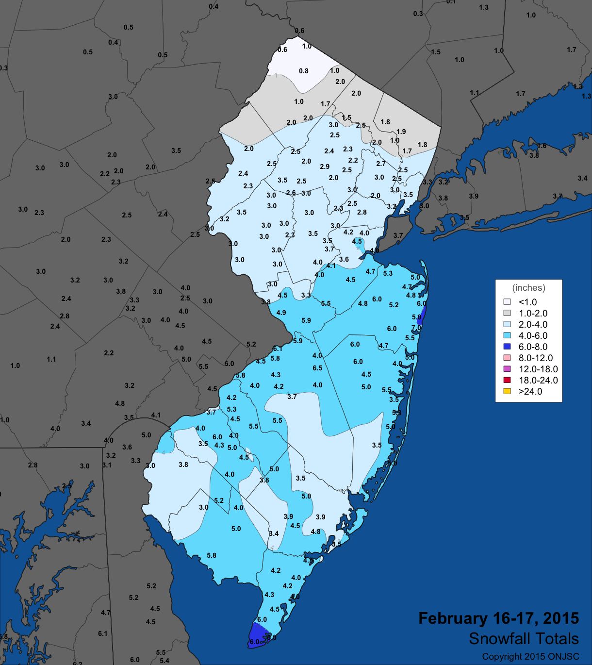
Figure 3. February 16th-17th snowfall totals from National Weather Service (NWS) Cooperative observers and spotters, and CoCoRaHS volunteers. For larger view, click here.
Snow to sleet to freezing rain was the order of the day over most of NJ on the 21st into the morning of the 22nd. Widespread snow totals of 3"–5" were observed, except less in the southeast corner. Western Camden and Gloucester counties received 4"–6", with maxima of 7.0" in Berlin (Camden), 6.6" at Bordentown (Burlington), 6.0" at three Gloucester locations, and 5.5" in Allendale (Bergen). Melted totals included 1.50" in Merchantville (Camden), 1.47" in Berlin, and 1.32" at two Washington Township (Gloucester) stations. Some 38 CoCoRaHS stations caught 1.00"–1.50", 102 from 0.50"–0.99", and 32 from 0.13"–0.49".
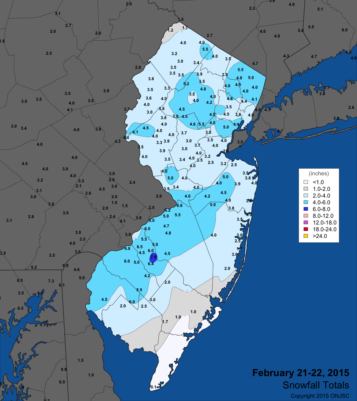
Figure 4. February 21st-22nd snowfall totals from National Weather Service (NWS) Cooperative observers and spotters, and CoCoRaHS volunteers. For larger view, click here.
The first half of the 26th saw moderate snowfall in Cape May, eastern Cumberland, and eastern Atlantic counties. Elsewhere, totals were under an inch except a few inch plus totals in some far northern areas. In Cape May County, Wildwood Crest received 6.5", Sea Isle City 6.0", and Middle Township 5.8". Liquid totals were 0.20"–0.30" in the snowiest areas.
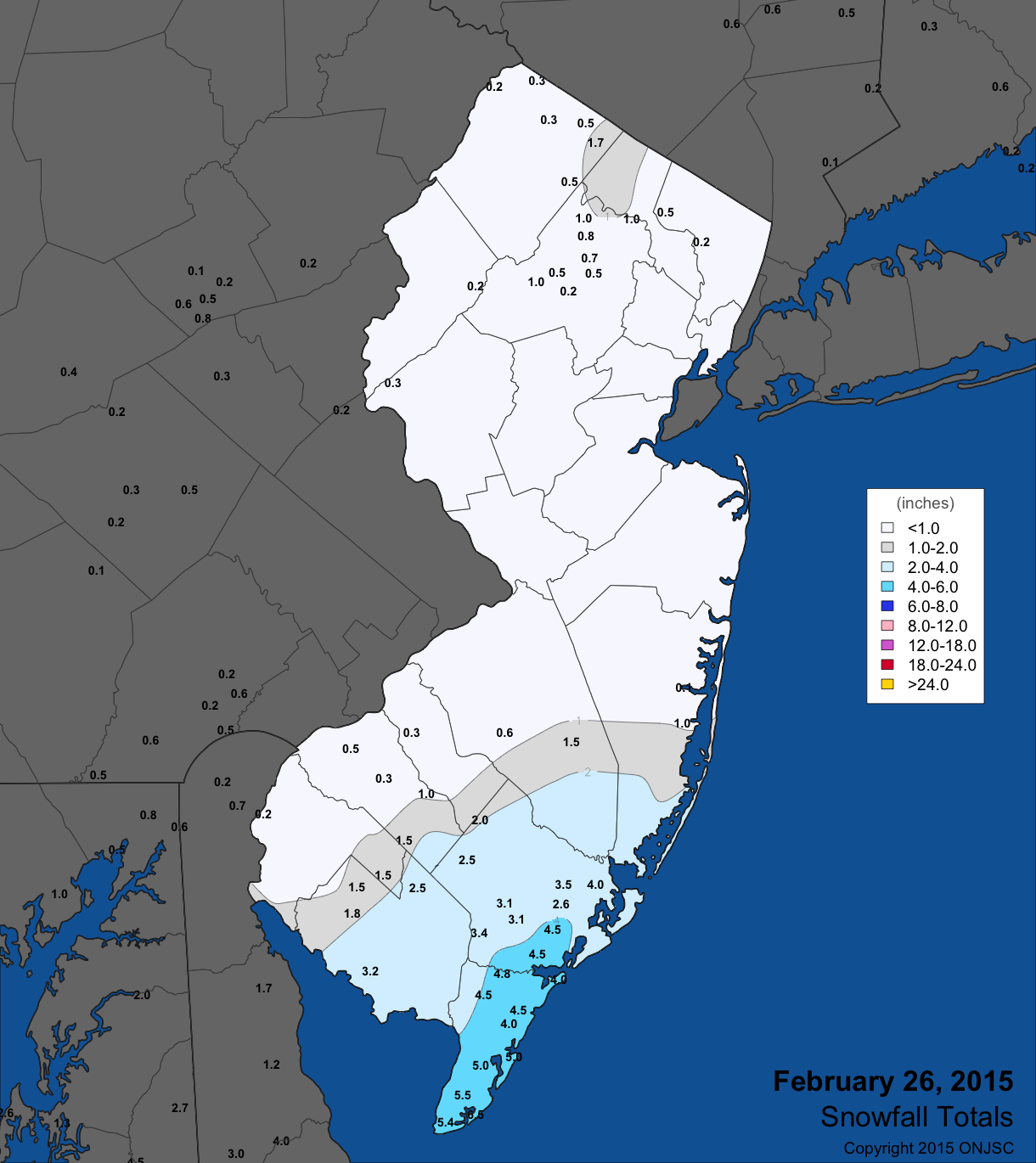
Figure 5. February 26th snowfall totals from National Weather Service (NWS) Cooperative observers and spotters, and CoCoRaHS volunteers. For larger view, click here.
Wind gusts exceeded 40 mph at one or more NJWxNet stations on ten February days. The second windiest day was the 2nd when High Point Monument saw a gust of 62 mph, Woodbine 50 mph, and nine stations gusting into the 40–49 mph range. The Monument reached 59 mph on the 3rd and 44 mph on the 4th, when Harvey Cedars (Ocean) peaked at 40 mph. High Point Monument reached 57 mph on the 12th when Wantage (Sussex) gusted to 49 mph. On the 13th, the Monument reached 55 mph, Wantage 48 mph, and Harvey Cedars 43 mph.
The 15th was the windiest day of February, with High Point Monument peaking at 64 mph, Wantage 61 mph, Bivalve 53 mph, Sea Girt (Monmouth) and West Cape May 51 mph, and Harvey Cedars and Woodbine 50 mph. 15 stations peaked between 40–49 mph and 22 of the NJWxNet more sheltered sites between 30–39 mph. This was followed by 58 mph at the Monument and 48 mph in Wantage on the 16th. These two stations gusted to 53 mph and 40 mph, respectively, on the 19th and both topped out at 50 mph on the 20th. The Monument got to 45 mph on the 23rd.
Peak barometric pressure during February was on the 28th, with the barometer at an exceptionally high 30.80"–30.85". The 14th saw minimum pressure close to 29.45".
Winter Overview
Statewide, the December through February temperature averaged 29.5°. This was the 21st coldest winter of the past 120 years and was 4.0° below normal (1981–2010 mean). While this may not sound too impressive, it was the coldest winter since 1993–1994, which was 29.0°. The coldest was 1917–1918 at 24.4°. Over the past 50 years, 1977 came in at 27.2° (6th coldest) and 1978 at 27.8° (9th). This past winter, December was over 3° milder than average while January was more than 3° below average, leaving the very cold February to push the season well into the negative category.
Rain and melted snow/ice amounted to 11.97" statewide during the three winter months. This was 1.71" above normal and the 30th wettest on record. December and January were an inch or more above average to outweigh February being a half-inch below the norm. Seasonal snowfall includes any snow falling from the late fall through early spring, thus will be summarized in April.
For those seeking more detailed information on hourly, daily and monthly conditions, please visit the following Office of the NJ State Climatologist's websites:
NJ Weather and Climate Network
NJ Community Collaborative Rain, Hail and Snow Network
NJ Snow Event Reports
Interested in receiving our monthly summaries at the end of each month? Send us your e-mail address here to join the mailing list.
Past News Stories

