Lambs and Lions: March 2019 Summary
New Jersey State Climatologist
Center for Environmental Prediction, School of Environmental and Biological Sciences/NJAES, Rutgers University
April 5, 2019
Overview
Much like last month, March 2019 had a wide variety of weather conditions across the Garden State. The month came in like a lion, with a week of wintry weather, which was particularly snowy in northern and central regions. More snow fell than in any other month this season and the temperature fell below zero in one location and down to single digits at a number of others. The remainder of the month was often lamb-like, including four days with high temperatures exceeding 70° at many locations and six in the 60°s. Several inch-plus rain events occurred, along with the first lightning-filled squall line of the year, which, in some locations, included hail and strong winds.
The statewide monthly temperature averaged 39.7°. This is 1.1° below the 1981–2010 average and is the 58th mildest (66th coolest) since 1895. The statewide average rain and melted snow totaled 3.91”. This is 0.20” below the 1981–2010 average. It was the 61st wettest (65th driest) March since 1895.
Statewide snowfall averaged 6.3”. This was 1.9” above average. Northern counties averaged 13.0” (6.7” above average), the central region 8.6” (+3.5”), and south 1.6” (-1.5”). As a preview of the seasonal snow summary in next month’s report, statewide snowfall through March is 20.5”, 5.0” below average. Barring the unlikely case of April snowfall exceeding any other month of the season, this will mark the first time since records began in 1895 that March was NJ’s snowiest month of the season for three consecutive snow seasons (October–April).
The NJWxNet welcomed a new station at Duke Farms in Hillsborough Township (Somerset County) on March 29th, thanks to support from the Duke Farms Foundation and the Rutgers Raritan River Consortium. In other network news, following an extended outage, the anemometer at High Point Monument (Sussex) was placed back into service on the 19th. Walpack (Sussex) temperature observations remain erratic, thus will not be reported until repairs are soon made.
Precipitation and Storms
There was a narrow range of precipitation across NJ in March. The five wettest locations included Chester (Morris) with 5.01”, followed by Califon (Hunterdon) 4.88”, East Brunswick (Middlesex) 4.78”, Lebanon (Hunterdon) 4.77”, and Bethlehem Township (Hunterdon) 4.73”. The driest spots were Stillwater Township (Sussex) 3.34”, Blairstown (Warren) 3.36”, Middle Township (Cape May) 3.39”, Stewartville (Warren) 3.62”, and Mount Ephraim (Camden) 3.65”. This does not include the less than 0.25” of rain that fell after March 31st morning observation times at most NWS Cooperative and CoCoRaHS stations, which, by observing convention, will appear in April 1st reports.
Snowfall topped out at 16.2” in Bethlehem Township, Sparta (Sussex) 15.7”, Randolph Township (Morris) 15.6”, Jefferson Township (Morris) 15.5” and 15.0” (two locations), Rockaway Township (Morris) 15.4”, and Blairstown 15.2”. The southeast corner of the state only saw close to 1.0” of the white stuff.
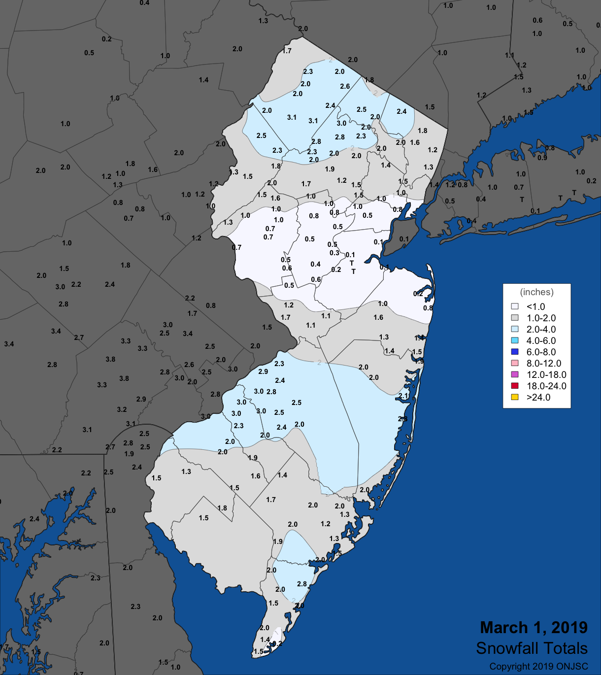
Snow fell in northern and southern counties early on the 1st. As had been so often noted this season, central regions remained almost snowless (Figure 1). Eleven counties had one or more stations receive 2.0” or more. The seven stations with 3.0” or more included 3.1” in both Newton (Sussex) and Sparta, and 3.0” at Marlton (Burlington), Jefferson Township, and three Camden county stations. The liquid equivalent from this event was under 0.25”.

Figure 1. Snowfall early on March 1st. Observations are from CoCoRaHS stations, NWS Coop and NWS spotter reports.
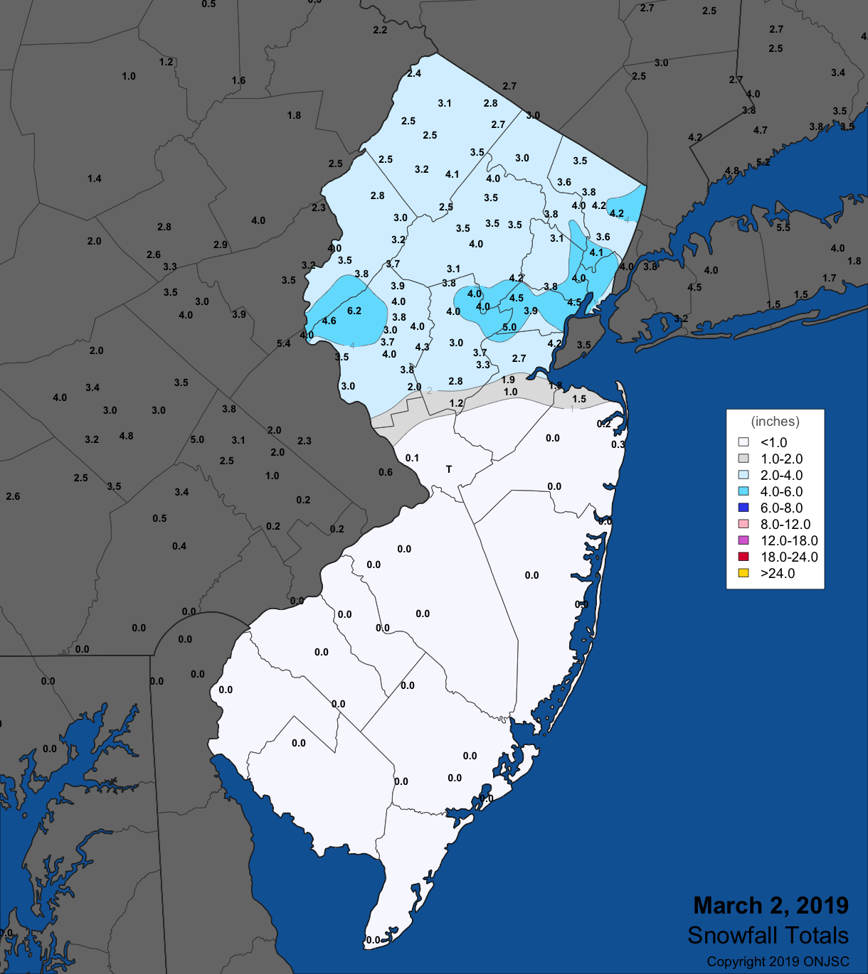
Snow resumed up north late on the 1st, continuing through the morning of the 2nd. Elsewhere, a sleet and rain mix transitioned to snow in central NJ and mainly rain fell in the south. Once again, 11 counties had one or more stations receive 2.0” or more, though not the same counties as a day earlier. Each one of them had a station of 4.0” or greater, including three stations at 4.2” in Bergen County, Newark Airport (Essex) 4.5”, Harrison (Hudson) 4.0”, Bethlehem Township 6.2”, Port Reading (Middlesex) 4.2”, Chatham (Morris) 4.2”, Little Falls (Passaic) 4.2”, Bernards Township (Somerset) 5.1”, Sparta 4.1”, Elizabeth (Union) 5.2”, and Stewartsville 4.3”. Snow accumulated along and north of the Route 1 corridor, with the heaviest band just to the north, within the Interstate 78 corridor (Figure 2). Whether it was melted snow or rain, totals across NJ storm totals were quite even, mostly within the 0.30”–0.60” range. A few heavier totals were observed in Lacey Township (Ocean) 0.96” and Toms River (Ocean) 0.75”.

Figure 2. Snowfall from late on March 1st to the morning of the 2nd. Observations are from CoCoRaHS stations, NWS Coop and NWS spotter reports.
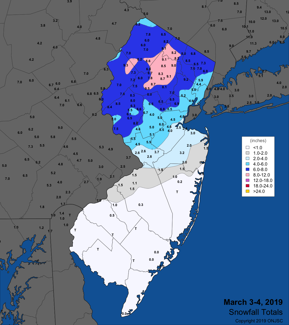
Not much more than a day later, the afternoon of the 3rd saw rain arrive in the south, rain transition within a few hours to wet snow in central areas, and mostly snow in the north. The core of the heaviest snow was in the Highlands, where more than 8.0” fell (Figure 3). Most of the state north of the Route 1 corridor received 5.0”, with totals tapering to less than an inch south of northern Burlington and Ocean counties. This storm rivaled but did not reach totals achieved in the November 15th–16th event, the largest event of the season averaged across NJ (unless April has a surprise event!). Table 1 shows the highest totals in the 12 counties where 5.0” or more accumulated.

Figure 3. Snowfall from the afternoon of March 3rd to the predawn hours of the 4th Observations are from CoCoRaHS stations, NWS Coop and NWS spotter reports.
| County | Location | Snowfall |
|---|---|---|
| Bergen | Bergenfield, Franklin Lakes, Paramus | 8.5” |
| Essex | Cedar Grove | 9.2” |
| Hudson | Harrison, Kearny | 5.0” |
| Hunterdon | Bethlehem Township | 8.5” |
| Mercer | Hopewell Township, Princeton | 5.5” |
| Middlesex | North Brunswick | 5.5” |
| Morris | Chester | 9.5” |
| Passaic | West Milford, Bloomingdale | 8.2” |
| Somerset | Bernards Township, Peapack-Gladstone | 8.0” |
| Sussex | Sparta | 8.6” |
| Union | Westfield | 6.9” |
| Warren | White Township | 8.0” |
Table 1. Largest snowfall in the eleven NJ counties where totals on March 3rd–4th equaled or exceeded 5.0”.
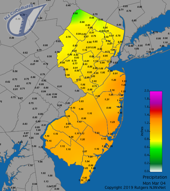
As with the previous event, whether in frozen or liquid form, the amount of water that fell was quite uniform across NJ (Figure 4). Top totals included Lacey Township 1.46”, Ocean Township (Monmouth) 1.44”, Berkeley Township (Ocean) 1.31”, and Long Branch (Monmouth) 1.30”. Of the 193 CoCoRaHS reports, 91 were between 1.00”–1.46” and 102 between 0.56”–0.99”. Montague (Sussex) had the least with 0.60”, with the other Sussex County communities of Branchville and Vernon Township catching 0.66” and 0.68”, respectively.

Figure 4. Rain and melted snowfall from the afternoon of the 3rd through the early hours of the 4th. Observations are from CoCoRaHS stations.
The next event brought mainly rain across NJ from the predawn hours of the 10th through late morning. Coastal areas received the most, with 1.37” in Brigantine (Atlantic), Sea Isle City (Cape May) 1.30”, Galloway Township (Atlantic) 1.29”, and Point Pleasant Beach (Ocean) 1.27”. The northwest saw the least precipitation, with Frankford (Sussex) at 0.29” and Montague 0.28”. However, this region saw some snow and sleet, including 1.1” at Montague and 0.7” in Randolph Township. The first wind gusts of the month exceeding 40 mph occurred on the 10th at Seaside Heights (Ocean), with a 42 mph gust. A 41 mph gust occurred at Lower Alloways Creek Township (LACT; Salem) on the 11th.
An evening squall on the 15th brought some heavy rain, hail, and considerable lightning to portions of northern and central NJ. Bethlehem Township caught 1.06”, Lebanon 1.05”, Ringwood (Passaic) 1.04”, and Denville (Morris) 1.03”. Hail from ¼” to ¾” in diameter fell at locations in Mercer, Hunterdon, Morris, Passaic, and Bergen counties. No measurable rain fell in the south. Winds gusted to 42 mph at LACT, and later, on the 16th, that location gusted to 44 mph while Pennsauken (Camden) hit 41 mph.
A storm moved northward along the coast beginning in the predawn hours of the 21st. The heaviest rain fell on the evening of the 21st with some wrap around bands of rain and snow finally leaving the state during the morning of the 22nd. Of the 216 CoCoRaHS stations reporting, 48 received 1.50”–1.84” and 132 caught 1.00”–1.49”. Central Jersey had the largest totals, including reports of 1.84”, 1.76”, and 1.68” at three Woodbridge (Middlesex) locations, Califon 1.83”, Peapack-Gladstone 1.72” and 1.81”, and New Brunswick (Middlesex) 1.68” and 1.64”. The least rain fell in the southeast, with Wildwood Crest (Cape May) catching 0.43” and Sea Isle City 0.55”. High Point Ranger Station (Sussex), at an elevation close to 1500’, received 3.3” of snow, while 0.5” accumulated further east in Highland Lakes (Sussex). Winds howled during the course of the storm and continuing through the 23rd. Harvey Cedars (Ocean) gusted to 43 mph and Berkeley Township 40 mph on the 21st. High Point Monument reached 62 mph on the 22nd, along with Fortescue (Cumberland) 55 mph, Vineland (Cumberland) 54 mph, and eleven NJWxNet stations gusting between 40–49 mph. The 23rd saw the Monument reach 63 mph, Fortescue 53 mph, and eight station from 40–49 mph. Closing out the month, High Point Monument reached 44 mph on the 31st.
The barometer bottomed out at 29.25”–29.35” during the storm on the 22nd. The March peak was from 30.50”–30.60” on the 27th.
Temperature
Temperatures were well below normal the first ten days of the month. In fact, nowhere in NJ did the maximum on the 6th exceed the freezing mark, and single-digit minimums occurred at multiple locations from the 5th–8th. Maximums later in the month exceeded 60° on nine days, three of them making it past 70°.
All told, there were 14 days with minimums of 20° or colder. On the 1st, High Point Monument fell to 15°, High Point (Sussex) 16°, and Sandyston (Sussex) 18°. Kingwood (Hunterdon) reached 20° on the 3rd. The three stations with cold lows on the 1st repeated on the 4th, with 13°, 15°, and 17°, respectively. Sandyston took low honors for the next five days. On the 5th this station fell to 2°, followed by High Point 4°, Pequest (Warren) 6°, and Charlotteburg (Passaic) 7°. 47 of the 63 NJWxNet stations dropped to 8°–20°. West Cape May (Cape May) at 25° began a four-day streak as the mildest location in the state that continued with lows of 22°, 24°, and 29°. Sandyston reached 0° on the 6th, with Pequest 5°, High Point Monument 6°, Basking Ridge (Somerset) 7°, and 55 stations between 9°–20°. The 7th was the coldest morning of the month, with Sandyston down to -4°, Pequest 1°, Basking Ridge 3°, 12 stations from 4°–8°, and 43 locations between 9°–20°. Sandyston was 0° on the morning of the 8th, later rebounding to a high of 38°. Pequest was 3° and Charlotteburg 4°. To end the string, Sandyston fell to 13° on the 9th and Pequest 18°.
Mid-month found Sandyston at 16°, Pequest 17°, and Hopewell Township and Berkeley Township each 18° on the 13th. There was an exact repeat performance at these sites on the 18th, and almost again on the 19th, except Sandyston “warmed up” to 17° and Berkeley Township to 19°. The foursome fell to 18° (Pequest and Sandyston) and 19° (Hopewell Township and Berkeley Township) on the 20th. Toward month’s end, Pequest and Berkeley Township reached 17° and Sandyston 18° on the 27th. On the 28th, Berkeley Township ranged from 16° to 56° and Hopewell Township from 19° to 59°.
The first mild day of March brought 71° highs to Hamilton (Mercer) and Red Lion (Burlington) on the 14th, with six stations at 70°. As is common in spring, coastal locations remain much cooler, witnessed by highs of 49° at Harvey Cedars and Sea Girt (Monmouth). The 15th was the warmest day of the month (along with the 31st). West Deptford (Gloucester) topped out at 78°, 17 sites were 76°–77°, and 30 from 70°–75°. Atlantic City Marina only made it to 53°. Vineland was 63° on the 16th, with 25 stations from 60°–62°.
Warmth resumed on the 24th, with both Sicklerville (Camden) and West Creek (Ocean) reaching 64° and 48 stations from 60°–63°. An offshore wind was blowing on the 25th, permitting Delaware Bay coast station Fortescue to rise to 63°, with 14 stations from 60°–62°. Hamilton and Sicklerville were 61° on the 28th. Cape May Court House (Cape May) and Upper Deerfield (Cumberland) made it to 67°, with 40 other locations from 60°–66° on the 29th. The 30th saw temperatures soar to 78° at both Howell (Monmouth) and New Brunswick, 77° at 10 locations, and 70°–76° at 36 other stations. Harvey Cedars only made it to 53°, with five other coastal stations topping out from 55°–59°. Ahead of an arriving cold front on the 31st, Sewell (Gloucester) reached 69°, and Cream Ridge (Monmouth) and New Brunswick each hit 65°.
Being a climatically transitional month, NJ thermometers often flirt with the freezing point on a daily basis. This March was no exception. During 27 days of the month, one or more NJWxNet station fell below freezing, leaving just 4 days with all stations remaining above freezing. However, only six of the freezing days saw every station bottom out below freezing. Meanwhile, on 26 days all NJWxNet stations surpassed the freezing point for a maximum temperature. Thus, only 5 days saw one or more station fail to crack that mark, with the aforementioned 6th seeing all stations remain frozen. Potholes, anyone??
For those seeking more detailed information on 5-minute, hourly, daily and monthly conditions, please visit the following Office of the NJ State Climatologist's websites:
Rutgers NJ Weather Network
NJ Community Collaborative Rain, Hail and Snow Network
NJ Snow Event Reports
Interested in receiving our monthly summaries at the end of each month? Send us your e-mail address here to join the mailing list.
Past News Stories

