Rainfall Corridors: July 2017 Summary
New Jersey State Climatologist
Center for Environmental Prediction, School of Environmental and Biological Sciences/NJAES, Rutgers University
August 4, 2017
Overview
July 2017 proved to be an active month of weather throughout the Garden State. Time and time again, storms traversed the state, often depositing the heaviest rainfall in 30–40 mile west-to-east “corridors,” while elsewhere totals were much lighter. Such is the nature of showery summer rainfall, although in one case, the swath of heavy rainfall was associated with an out-of-season coastal storm. When all was said and done, rainfall occurred frequently enough to leave most locations with average to well above average monthly totals. The statewide average July rainfall was 6.33”. This is 1.76” above the 1981–2010 average and ranks as the 19th wettest July of the past 123 years. Last year with 6.97” (ranking 13th) and 2004 with 7.51” (ranking 8th) were the most recent Julys to be wetter than this year. The statewide average temperature of 75.5° was 0.9° above average. This ranks as the 22nd warmest July on record. There have been nine warmer Julys since 2002, including last year at 77.1° (ranking 7th).
Precipitation and Storms
The typical wide-range of precipitation totals for a summer month occurred across NJ in July. Totals ranged from four times the long-term average for July to about half of average. The wettest locations were in south Jersey, although portions up north had some hefty amounts too. Fairfield Township (Cumberland County) took top honors with 11.46”. This was followed by Ocean City (Cape May) with 10.94” and 8.74” (summer rainfall can vary a fair bit even within a community), Franklin Township (Gloucester) 9.66”, Sea Isle City (Cape May) 9.42”, and Egg Harbor City (Atlantic) 9.15”. On the dry side was an area in northern Ocean and coastal Monmouth counties, where Lacey Township (Ocean) only saw 2.62” fall. Berkeley Township (Ocean) received 2.99”, two Long Branch (Monmouth) stations 3.15” and 2.22”, Eatontown (Monmouth) 3.43”, and Brick (Ocean) 3.51”. It was not until late month that eastern Burlington County saw much rain either, thus a lightning strike on the 19th sparked what became a 3500-acre forest fire in Wharton State Park, just north of Batsto Village (Burlington). The fire, one New Jersey’s largest in over a decade, was fully contained and controlled by 24th. Fortunately, there were no injuries or damaged structures associated with the fire.
There were ten events during the month where more than an inch of rain fell at one or more locations around the state, with one of these events stretching out over several days. These will be discussed below, along with one event that produced strong winds and nearly an inch of rain in a few locations. Maps depicting some of the aforementioned rainfall corridors will accompany the discussion of some of the events.
The month got off to a wet start, particularly in the northern Highlands, where late afternoon and evening thunderstorms on the 1st deposited 1.96” and 1.68” at two Oakland (Bergen) stations, 1.68” in Ringwood (Passaic), and 1.24” and 1.20” at two Boonton (Morris) sites. Rain tapered off to the south, with none falling along the southern coast. However, there was wind damage to trees and power lines as far south as Burlington County, to go along with similar reports from Hunterdon and Mercer counties. Scattered afternoon and evening showers occurred on the 4th, although most of the state got through the holiday without rain. One nearly stationary cell deposited 2.02” in Fairfield Township (Cumberland). 1.04” also fell in West Deptford (Gloucester) and 0.42” in Mt. Ephraim (Camden).
Heavy rain fell on the 7th, especially from the Interstate 78 corridor northward, where more than an inch was common and north of Interstate 80 with 2” plus totals (Figure 1). Of 207 CoCoRaHS reports, 13 came in with more than 3.00”, 36 between 2.00”–2.99”, and 46 from 1.00”–1.99”. Much of the remainder of NJ was within a few tenths of 0.50”, except less fell in Ocean, Burlington, and Cape May counties. Top totals were 3.81” at Charlotteburg (Passaic), Pequest (Warren) 3.75”, Rockaway (Morris) 3.68”, Liberty Township (Warren) 3.58”, two Oakland locations with 3.55” and 3.27”, and Ringwood with 3.47”. Hail was reported with the rain in Holland Township (Hunterdon), Buena Vista (Atlantic), and Hamilton Township (Atlantic).
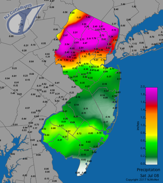
Figure 1. Rainfall from the morning of July 7th to morning of July 8th.
Rainfall was concentrated in the Interstate 195 corridor and in Cape May County from thunderstorms during the evening of the 13th (Figure 2). Ocean City saw 2.35”, Upper Freehold (Monmouth) 2.20”, Jackson Township (Ocean) 2.18”, and Cream Ridge (Monmouth) 2.15”. Scattered areas in the northwest received 0.50”–1.00”, with less elsewhere and under 0.20” in a loop from Salem and Gloucester counties over to southern Ocean County. Poles and wires were reported down in Hunterdon and Monmouth counties.
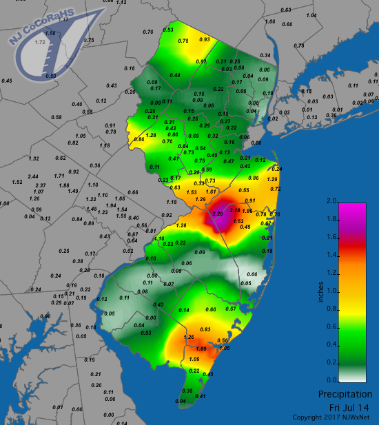
Figure 2. Rainfall from the morning of July 13th to morning of July 14th.
Evening storms in the south on the 14th brought 3.35” and 3.11” to Dennis (Cape May) stations, 3.25” and 2.97” in Middle Township (Cape May), 2.79” in Fairfield Township (Cumberland), and 2.71” at Cape May Courthouse (Cape May; Figure 3). More than 1.50” fell through Salem, Cumberland and Cape May counties, with totals within a few tenths of 0.50” over much of the rest of NJ. Again, portions of Burlington and Ocean counties saw the least, with less than 0.20”. Trees and wires were reported down in southern counties.
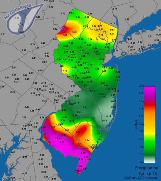
Figure 3. Rainfall from the morning of July 14th to morning of July 15th.
A week of heat and humidity accompanied by frequent scattered showers began on the 17th. Late that afternoon, showers from Hunterdon and Warren counties northeastward into the northern Highlands brought 1.32” to Oakland, and 1.10” and 0.89” at two Boonton locations. Little to no rain fell elsewhere. The far northwest corner of Sussex County was soaked during the midday hours of the 18th when High Point received 1.37”, Montague 1.32”, and one Wantage station 1.03”. Meanwhile, another Wantage location only caught 0.24” and the remainder of NJ did not see a raindrop. A gusty line of storms moved through northern and central NJ on the evening of the 20th. Due to the quick-moving nature of the storms, the top total was only 0.86” in Bethlehem (Hunterdon) and 0.77” at Liberty Township. The west central counties eastward to Raritan Bay saw at least several tenths of an inch fall, with little elsewhere. Trees were reported toppled in Warren, Hunterdon, and Mercer counties.
Two shots of rain hit portions of the state on the 22nd. The predawn hours saw Cape May County collect up to 1.18” in Wildwood Crest, 0.90” in North Wildwood, and 0.89” and 0.76” in Lower Township. Scattered afternoon and evening rain and thunderstorms brought heavy rain to central areas, especially along the Route 1 corridor (Figure 4). North Brunswick (Middlesex) received 2.35”, East Brunswick (Middlesex) 2.14”, Flemington (Hunterdon) 2.02”, four Hillsborough (Somerset) sites saw 2.01”, 1.74”, 1.34”, and 0.82”, and Montgomery (Somerset) 1.90”. Totals tapered off to the north and south, with little to no rain south of the Atlantic City Expressway. Trees and wires were reported down in Camden, Burlington, Gloucester, and Salem counties.
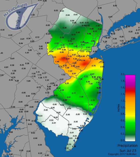
Figure 4. Rainfall from the morning of July 22nd to morning of July 23rd.
A few scattered showers during the afternoon of the 23rd transitioned to heavier rain in the southwest during the evening. Reports of trees and wires down came from seven counties as far ranging as Warren, Monmouth, Atlantic, and Salem. In the predawn hours of the 24th a corridor of heavy rain made its way eastward from Salem and Gloucester counties to southern Ocean and northern Atlantic counties (Figure 5). Within this band were totals exceeding 2.00” and in some locations 3.00”. Elsewhere, widespread overnight showers continued into a round of morning showers in central and northern NJ on the 24th. More showers sprang up during the afternoon and persisted into the pre-dawn hours of the 25th, especially in the south. Finally, some late afternoon and evening showers across the state on the 25th ended this multi-day episode. All told, rainfall from the afternoon of the 23rd through the evening of the 25th brought totals up to 6.15” in Franklin Township (Gloucester), 5.77” at Monroe Township (Gloucester), 5.30” in Evesham (Burlington), and 5.14” at Berlin (Camden). Some 15 stations caught 3.00”–3.99”, 31 had between 2.00”–2.99”, and 125 sites received 1.00”–1.99”. The least rainfall occurred in Oakland (0.56”) and Bloomingdale (Passaic; 0.60”). The heavy rainfall in the south from this multi-day event and from earlier storms brought rivers, including the Maurice River in Cumberland and Salem counties, the Salem River in Salem County, and the Cohansey River in Cumberland County to low flood stages.
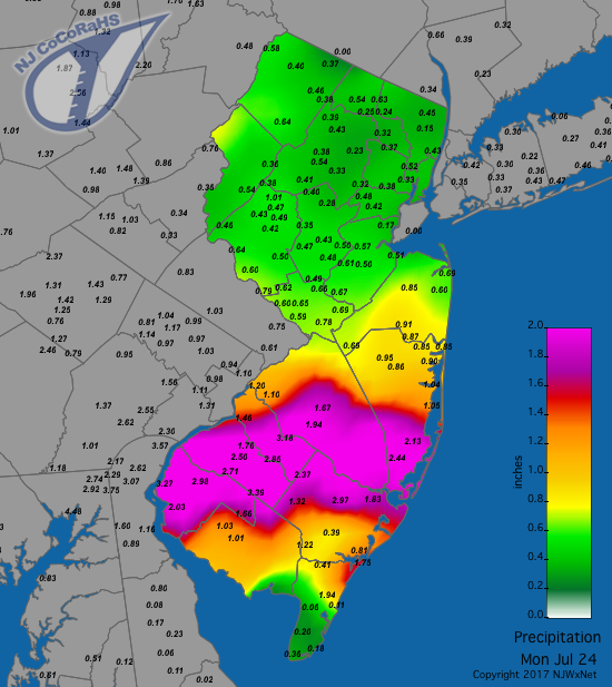
Figure 5. Rainfall from the morning of July 23rd to morning of July 24th. These totals were from the beginning of the multi-day event.
A busy month concluded with an out-of-season coastal storm depositing heavy rain across south Jersey from late on the 28th into the morning of the 29th (Figure 6). The Atlantic City Airport in Pomona (Atlantic) received a record 5.41”. In Cape May County, Wildwood Crest was drenched with 5.03”, Sea Isle City 4.74”, Lower Township 4.65”, and North Wildwood 4.30”. Rainfall only exceeded an inch in Cape May, Cumberland, and Atlantic counties, tapering to less than 0.25” northward in the Interstate 195 corridor and nothing but a few sprinkles in north Jersey. The southern rains kept rivers high and washed out a road near Vineland (Cumberland).
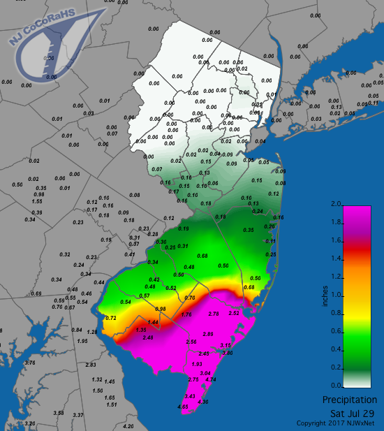
Figure 6. Rainfall from the morning of July 28th to morning of July 29th.
Winds gusted to 40 mph or higher on eight days. On all but one of them (the 29th) gusts accompanied thunderstorm activity. Pittstown (Hunterdon) reached 40 mph on the 1st, with Logan Township (Gloucester) and Sea Girt (Monmouth) achieving that same mark on the 7th and 13th, respectively. The 14th found Millville Airport (Cumberland) gusting to 58 mph, Mannington (Salem) 55 mph, Fortescue (Cumberland) 44 mph, and Upper Deerfield (Cumberland) 40 mph. Pittstown reached 45 mph on the 17th, topping that at 47 mph on the 20th, when Hopewell Township (Mercer) peaked at 41 mph. Pennsauken (Camden) reached 45 mph on the 24th. The coastal storm on the 29th brought gusts of 46 mph to Harvey Cedars (Ocean) and 41 mph at Seaside Heights (Ocean), with nine other locations peaking between 30–39 mph.
The highest barometric pressure in July occurred on the 26th, with values between 30.25”–30.30”. The lowest was on the 29th with values between 29.65”–29.70” in south Jersey and 29.70”–29.75” in the north.
Temperature
The maximum temperature reached 90° or higher somewhere within the state on 15 July days, all between the 1st and 22nd. Greenwich (Cumberland) started things off at 90° on the 1st. Toms River (Ocean) got to 93° and three other NJWxNet stations to 92° on the 2nd. This was followed by the 93° mark being reached on the 3rd at Cape May Courthouse, Woodbine (Cape May), and Toms River. The 4th saw 91° at Hammonton (Atlantic), South Harrison (Gloucester), Upper Deerfield, and West Deptford (Gloucester).
The 8th found West Creek (Ocean) up to 90°. Toms River reached 94° and Berkeley Township, Oceanport (Monmouth), and Oswego Lake (Burlington) 93° on the 11th. Cape May Courthouse reached 94° on the 12th, followed by Oceanport and West Creek at 93° and 37 of the 65 NJWxNet stations between 90°–92°. It was hotter on the 14th, with Cape May Courthouse hitting 98°, Oceanport, Seaside Heights, and Toms River to 97°, and 45 stations between 90°–96°. Greenwich (Cumberland) and Upper Deerfield reached 90° on the 14th.
Following several cooler days, 90° was reached at Cherry Hill (Camden) and Mansfield (Burlington) on the 17th. Red Lion (Burlington) topped out at 93° on the 18th, with six stations at 92°. Red Lion again led the way on the 19th at 96°, Hawthorne (Passaic) was 95°, and 43 stations were between 90°–94°. The 20th was the hottest day of the month, with Red Lion and Toms River sizzling at 98°, Hawthorne 97°, and 53 stations between 90°–96°. High Point and Wantage were the “coolest” stations at 87°. This was also a humid day, thus the heat index, which is derived using temperature and humidity observations, exceeded 100° in many locations and was even above 105° in spots. The next two days were not much better, with Red Lion and Bivalve (Cumberland) temperatures on the 21st up to 95° and five stations at 94°. Pennsauken, Red Lion, and Silas Little (Burlington) topped out at 95° on the 22nd.
Minimum temperatures dropped into the 50°s on 14 days during the month, two of which (4th and 17th) also saw high temperatures reaching 90°, although the extremes were not at the same locations on either day (FYI, the High Point Monument (Sussex) station was out of commission from the 1st–26th). Walpack (Sussex) fell to 58° on the 4th and was a chilly 51° on the 5th, when Charlotteburg was 57°. The 9th saw Walpack down to 52°, High Point at 54°, and 15 stations between 55°–59°. The 10th found Basking Ridge (Somerset) and Walpack at 51° and 34 stations between 52°–59°. Walpack fell to 58° on the 15th. Pequest reached 55° on the 16th, with Basking Ridge and Walpack 56°. Walpack was 59° on the 17th.
The last week of the month brought a number of cool mornings, with High Point down to 57° on the 24th and Wantage 59°. High Point reached 55° on the 25th, with four stations at 57°. Basking Ridge fell to 56° on the 26th, with four stations at 57°. The 27th saw the thermometer dip to 54° at Berkeley Township, Howell (Monmouth), and Basking Ridge, with 25 stations between 56°–59°. The 29th found Walpack at 49° and Pequest 52°. The final two days of July had the coolest mornings, with Walpack down to an impressive 43° on the 30th, Pequest 47°, Basking Ridge 49°, and 48 NJWxNet stations between 50°–59°. The 31st found Berkeley Township at 49°, four stations at 50°, and 49 others between 51°–59°. Seaside Heights was mildest at 65°.
For those seeking more detailed information on hourly, daily and monthly conditions, please visit the following Office of the NJ State Climatologist's websites:
NJ Weather and Climate Network
NJ Community Collaborative Rain, Hail and Snow Network
NJ Snow Event Reports
Interested in receiving our monthly summaries at the end of each month? Send us your e-mail address here to join the mailing list.
Past News Stories

