

Wind Conditions Associated with the Seaside Boardwalk Inferno
New Jersey State Climatologist
September 16, 2013
A fast moving fire destroyed buildings housing at least 50 business along a four-block section of boardwalk in Seaside Park and Seaside Heights during the afternoon and evening of September 12th. The heroic actions of hundreds of firefighters and many others kept the inferno from spreading even further north up the boardwalk. Fortunately only minor injuries occurred. There is no question that strong winds blowing from the south contributed to the rapid spread of the fire. Perhaps a mid-evening slackening of the winds and a late evening shift in direction to a more westerly component assisted in bringing the fire under control. Here is a synopsis of wind gusts in the area during the time of the fire. Observations were taken at the Office of the NJ State Climatologist's NJ Weather and Climate Network (NJWxNet) station atop the Seaside Heights Municipal Building. Peak gusts each five minutes were recorded by an anemometer located approximately 40 feet above the ground. The station is seven blocks north of Lincoln Avenue, the location where the fire's advance was brought to a halt.
Peak gusts for every five-minute period between 2 PM and 11 PM EDT on the 12th are plotted in the Figure 1, while the directions of the gusts are plotted in Figure 2. They depict an afternoon and evening where winds were commonly gusting above 20 mph and reached their peak intensity of 30 mph at both the 5:00 and 5:05 observations (within five minute intervals ending at these times). The two maximum observations had wind directions of west-southwest (WSW) and SW, respectively. To put these 30 mph gusts in some climatological perspective, the last time a gust at Seaside Heights exceeded 30 mph was this past June 24th when a 39 mph gust occurred in a thunderstorm. While 30 mph gusts were also reached on June 27th, July 19th and 29th, and August 24th, none of these days had gusts exceeding 20 mph for nearly as long an interval as seen on September 12th.
Figure 1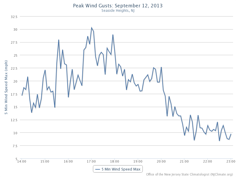
|
Figure 2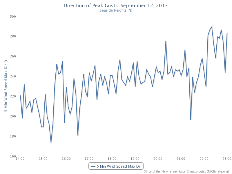
|
|---|
The first 20 mph gust occurred at 1:45 coming from a SW direction, with the second gust of 20 mph or greater (21 mph) at 2:15 from the SSW. The first 25 mph or greater gust was 28 mph at 3:35 from the WSW. Between 3:30 and 6:25 every five-minute interval except three had a gust exceeding 20 mph. The last 20 mph plus gust of the day was at 23 mph from the WSW at 8:00. The first five-minute gust under 10 mph was 8 mph from the WSW at 10:30, with the first gust from north of west a 13 mph WNW gust at 11:15 PM. All gusts from 2PM until 8:15 PM were from the south to WSW. The first gust directly from the west was 17 mph at 8:20, however the predominant direction remained SW or WSW until 10:30 PM.
Unlike some areas of NJ that received rain during the evening of the 12th, no measureable rain (at least 0.01") fell at the Seaside Heights station. The air temperature ranged from a high of 80° at 3:30 to minimum of 73° at 11:00.
As demonstrated here, observations from one or more of the 56 NJWxNet stations situated throughout the state can assist those making critical decisions not only during storms such as Hurricane Sandy but also when non-weather events that may be greatly impacted or influenced by atmospheric conditions strike the Garden State.
For those seeking more detailed information on hourly, daily and monthly conditions, please visit the following Office of the NJ State Climatologist's websites:
NJ Weather and Climate Network
NJ Community Collaborative Rain, Hail and Snow Network
NJ Snow Event Reports
Interested in receiving our monthly summaries at the end of each month? Send us your e-mail address here to join the mailing list.
Past Climate Summaries