Hit or Miss: June 2021 Recap
New Jersey State Climatologist
Center for Environmental Prediction, School of Environmental and Biological Sciences/NJAES, Rutgers University
July 8, 2021
Overview
June was a hit or miss month when it came to rainfall, even within counties. Of course, this is not all that uncommon during the warm season, where much of the rainfall arrives courtesy of localized showers and thunderstorms. There were also ups and downs of the thermometer during the month, including some chilly mornings. Overall, the balance was weighted towards the warm side of the ledger, resulting in a top 10 ranking for June temperature.
The statewide average temperature of 71.9° was 1.6° above the 1991–2020 normal (3.0° greater than the 1895–2021 average). This ties the month with 2011 as the 8th warmest since records commenced in 1895 (Table 1). Seven of the 16 warmest Junes of the past 127 years have occurred in just the past 17 years. The average high of 82.7° was 1.7° above normal and ties as the 11th warmest, while the average low of 61.0° was 1.4° above normal and ranks 8th warmest.
| Rank | Year | June Avg. Temp. |
|---|---|---|
| 1 | 2010 | 73.9° |
| 2 | 1943 | 73.6° |
| 3 | 2008 | 73.0° |
| 3 | 1925 | 73.0° |
| 5 | 1994 | 72.2° |
| 6 | 2005 | 72.1° |
| 7 | 1957 | 72.0° | 8 | 2021 | 71.9° |
| 8 | 2011 | 71.9° |
| 10 | 1934 | 71.8° |
| 11 | 2020 | 71.6° |
| 12 | 1973 | 71.5° |
| 13 | 1976 | 71.4° |
| 14 | 1923 | 71.3° |
| 15 | 2013 | 71.2° |
| 15 | 1989 | 71.2° |
Table 1. The 16 warmest Junes across NJ since 1895.
Statewide precipitation in June averaged 3.35”. This is 0.95” below average and ranks as the 57th driest of the past 127 years. The locally-varied monthly totals are shown well in Figure 1 with above and below normal totals in close proximity to one another. Generally, the northern portion of NJ was drier, averaging 2.96”, which is 1.65” below normal and ties as the 31st driest since 1895. Southern counties and the coastal region fared better, with an average of 3.61” in the south, which is 0.53” below normal and ties as the 54th wettest or 72nd driest. Coastal locations averaged 3.56” which is 0.29” below normal and is the 78th driest or 50th wettest. New Jersey stayed out of any drought categorization as enough rain fell often enough to keep things rather green. It will be important for such timing to continue or greater rainfall to arrive to keep NJ drought-free over the remainder of the warm season.
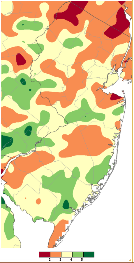
Figure 1. June 2021 precipitation across New Jersey based on a PRISM (Oregon State University) analysis generated using NWS Cooperative and CoCoRaHS observations from 7 AM on May 31st to 7 AM on June 30th. Note the scale in inches at the bottom of the figure. Totals range from 1.00”–2.00” (red) to 5.00”–6.00” (dark green).
A new station joined the Rutgers NJ Weather Network constellation on June 9th when Little Egg Harbor Township (Ocean County) was commissioned. This station is located within a salt marsh near the Rutgers Marine Science Center. It fills a gap in coastal coverage between the Atlantic City Marina (Atlantic) and Harvey Cedars (Ocean) NJWxNet stations. All equipment is installed with the exception of the anemometer that will soon be mounted at a height of 10 meters.
Temperature
The daily maximum temperature equaled or exceeded 90° at one or more NJWxNet station on 12 June afternoons. The initial run of 90° days ran from the 5th to 9th. The first day of this heatwave found coastal Seaside Heights (Ocean) the warmest at 94°, followed by Jersey City (Hudson) with 93°, and 44 of the 64 NJWxNet stations between 90°–92°. The coolest location was West Cape May (Cape May) at 83° (Figure 2).
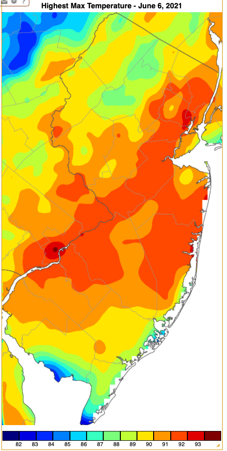
Figure 2. Maximum temperatures on June 5th based on a PRISM (Oregon State University) analysis generated using NWS, NJWxNet, and other professional weather stations. Note the scale in °F at the bottom of the figure.
The 6th saw Toms River (Ocean) and Howell (Monmouth) leading the pack at 95°, with 48 stations from 90°–94°. Six stations reached 94° on the 7th, and 35 locations came in from 90°–93° on the 8th. Lyndhurst (Bergen) topped out at 93° on the 9th. Heatwave #2 arrived on the 19th when Pennsauken (Camden) hit 91°, Mannington (Salem) was 91° on the 20th, and East Brunswick (Middlesex) 91° on the 21st.
June ended with a heatwave from the 27th to 30th. The first day saw East Brunswick up to 93° and 27 stations either 90° or 91°. Haworth (Bergen), Hillsborough-Duke (Somerset), and East Brunswick topped out at 95° on the 28th, with 45 stations from 90°–94°. The humidity became excessive, helping to elevate nighttime low temperatures. Witness 58 stations with lows from 70°–76° on the morning of the 28th, with Walpack (Sussex) coolest at 65°. The 29th found highs of 97° in East Brunswick, Berkeley Township (Ocean), and Haworth, 18 stations either 95° or 96°, and 37 in the lower 90°s. The coolest high was 82° at Atlantic City Marina. Again, 58 locations saw minimums from 70° to a 78°, with Walpack 66°.
The 30th was the hottest day of the season thus far, with the century mark reached at the NJWxNet Jersey City station. A NWS Cooperative station in Harrison (Hudson) reached 101°. A report of a June record 103° at Newark Airport (Essex) is being investigated, as in recent weeks this location appears to be running a degree or two warmer than believed to be accurate. This has been noted not just by examining absolute temperatures but also departures from normal compared to nearby stations. Whatever the case at this station, the region was hot and humid, including 40 NJWxNet stations rising to 95°–99° and 20 from 90°–94° (Figure 3). Atlantic City Marina had the lowest high of 84°. Even High Point Monument (Sussex) got into the act, topping out at 91°. This was the Monument’s first 90° reading since reaching 90° on July 3, 2018, and the warmest at the state’s highest location since hitting 95° on July 6, 2010. Humidity levels remained high, resulting in lows again in the 70°s at 56 NJWxNet station, with Walpack at 65°.
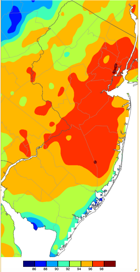
Figure 3. Maximum temperatures on June 30th based on a PRISM (Oregon State University) analysis generated using NWS, NJWxNet, and other professional weather stations. Note the scale in °F at the bottom of the figure.
In between the three heatwaves were some comfortable dry days with some chilly morning temperatures, particularly in northwestern valleys. Nine days had lows in the 30s and 40s at NJWxNet stations. The 1st saw Walpack drop to 39°, with 26 NJWxNet stations between 41°–49°. Walpack was 46° on the 2nd. Cool conditions returned mid-month, with Walpack 42° and Sandyston (Sussex) 45° on the 16th. The 17th was the coldest morning of the month, with Walpack an impressive 34°, Sandyston 37°, Pequest (Warren) 40°, and 24 stations from 43°–49° (Figure 4). Dew points were in the 30°s and 40°s throughout the day. Seaside Heights and Harvey Cedars only fell to 62° that morning. Walpack reached 38° on the 18th but rebounded to 83° in the afternoon. That morning, 13 stations were between 41°–49° while Fortescue (Cumberland) only dropped to 68°.
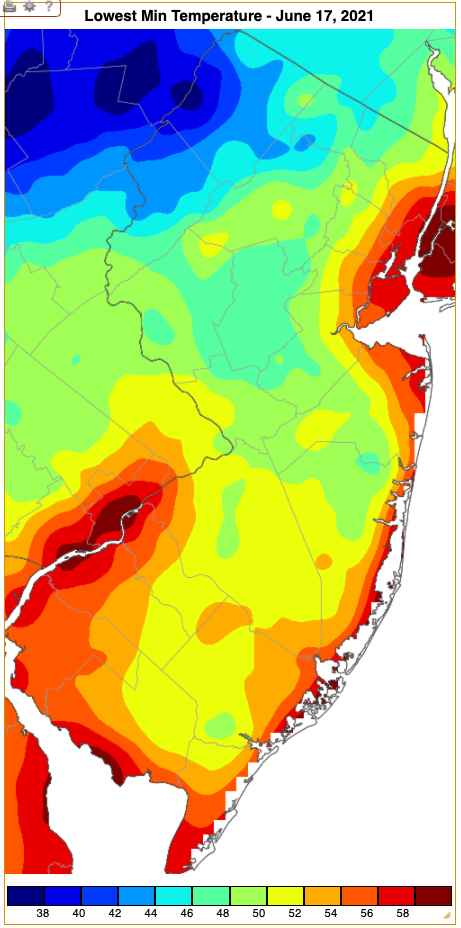
Figure 4. Minimum temperatures on June 17th based on a PRISM (Oregon State University) analysis generated using NWS, NJWxNet, and other professional weather stations. Note the scale in °F at the bottom of the figure.
Four more days of 40°s followed from the 22nd–25th, beginning with 45° at Walpack and 47° at High Point Monument. Sandyston was 40° on the 23rd, Pequest 42°, and 24 locations from 43°–49°. Sandyston and Walpack were both 42° on the 24th, with 26 sites from 43°–49°. On the 25th, Walpack was 42°, Basking Ridge (Somerset) and Sandyston each 44°, and 13 stations from 45°–49°.
Precipitation and Storms
The wettest NJ location in June was Bass River Township (Burlington), where a CoCoRaHS observer measured 6.51”. This was followed by Folsom (Atlantic) with 6.08”, Hamilton Township (Mercer) 5.78”, Freehold (Monmouth) 5.60”, and Jefferson Township (Morris) 5.54”. On the low side was Middletown (Monmouth) at 1.44”, Little Falls (Passaic) 1.77”, West Milford (Passaic) 1.79”, two Oakland (Bergen) stations with 1.83” and 1.94”, and Manasquan (Monmouth) 2.06”.
There were 11 June days where a gauge in NJ picked up at least an inch of rain, with stations catching two or more inches on four of these days. The first event began with some heavy southeastern thunderstorms during the pre-dawn hours of the 3rd, with evening storms mostly in central areas. Maurice River Township (Cumberland) with 2.17” was wettest followed by Bass River Township at 1.95”, Hopewell Township (Mercer) 1.66”, and Princeton (Mercer) 1.61” (Figure 5). Of the 259 CoCoRaHS reports, 42 came in with 1.00”–1.60”. Winds gusting as high as 45 mph at Fortescue brought down some trees and wires in Mercer, Atlantic, and Cumberland counties.
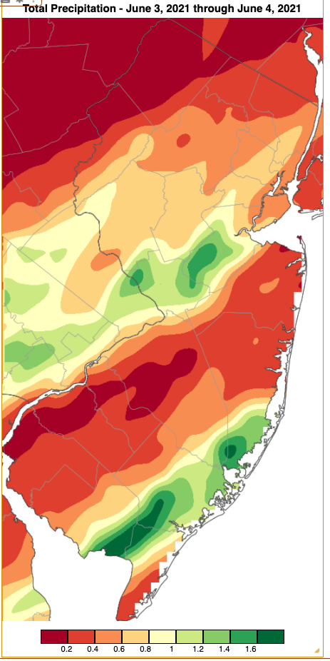
Figure 5. Rainfall from approximately 7 AM on June 2nd to 7 AM on June 4th based on a PRISM (Oregon State University) analysis generated using NWS Cooperative and CoCoRaHS observations. Note the scale in inches at the bottom of the figure.
An afternoon squall line on the 4th moved through northern and central areas, causing some wind damage in multiple counties. Woodbridge (Middlesex) saw 1.60”, Jefferson Township 1.58”, and Newton (Sussex) 1.51”. Of the 247 CoCoRaHS reports, 18 were from 1.00”–1.46” and 70 between 0.50”–0.99”. Scattered afternoon showers on the 7th in the north and along the coast brought Brick (Ocean) 1.82”, Knowlton Township (Warren) 1.75”, Wall (Monmouth) 1.28”, and Jackson (Ocean) 1.05”.
Afternoon and evening thunderstorms on the 8th delivered some quite localized soaking rain to places such as Hammonton (Atlantic), with three stations coming in with 3.56”, 3.02”, and 2.55”, joined by Haworth at 3.35” (including 2.68” in 45 minutes), Raritan (Hunterdon) 3.01”, Franklin Township (Hunterdon) 2.41” and 2.29”, and Pittstown (Hunterdon) 2.51” (Figure 6). Winds brought down trees and wires in a scattering of counties such as Bergen, Gloucester, Atlantic, and Ocean.
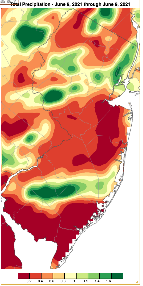
Figure 6. Rainfall from approximately 7 AM on June 8th to 7 AM on June 9th based on a PRISM (Oregon State University) analysis generated using NWS Cooperative and CoCoRaHS observations. Note the scale in inches at the bottom of the figure.
Scattered afternoon and evening thunderstorms on the 9th again brought down trees and power lines in several southern counties. Most impressive was the 60-mph gust at Lower Alloways Creek Township (Salem) in an isolated severe storm at this upper Delaware Bay location. Rain accompanying this storm accumulated to 3.68”, including 1.07” falling in ten minutes and 3.62” in an hour. Elsewhere, Freehold caught 2.30” and Howell 2.19”. Of 249 CoCoRaHS reports, only 18 received 0.50”–2.13”. Tragically, this storm took the life of a golfer in Burlington County who was struck by lightning. This was the first lightning death in the United States this year and the first in New Jersey since 2012.
A steady daytime rain event in south Jersey on the 11th brought Cape May County communities 1.51” in Wildwood Crest, Lower Township 1.28”, Middle Township 1.23”, and North Wildwood 1.20”. Afternoon and evening thunderstorms on the 14th brought soaking rain to a good portion of south Jersey, with less received to the north. Folsom was drenched with 3.07”, Freehold 2.75” and 2.40”, Vineland (Cumberland) 2.65”, Buena Vista (Atlantic) 2.45”, and Long Branch 2.35” (Figure 7). Some 31 stations caught from 1.00”–2.21” and 68 sites from 0.50”–0.99”. Tree and power line damage was reported from strong winds in seven counties from Sussex to Salem counties.
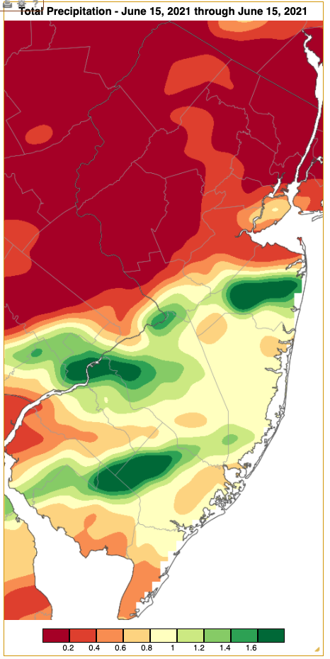
Figure 7. Rainfall from approximately 7 AM on June 14th to 7 AM on June 15th based on a PRISM (Oregon State University) analysis generated using NWS Cooperative and CoCoRaHS observations. Note the scale in inches at the bottom of the figure.
North and central areas caught the most rain in afternoon and evening showers on the 19th, with Rockaway (Morris) receiving 1.12” and both Denville (Morris) and Wayne (Passaic) 1.07”. Gusty evening storms on the 21st deposited 1.10” in Knowlton Township, 0.84” at Sparta (Sussex), and 0.79” in Lower Alloways Creek Township. Peak gusts included 52 mph at the latter site, 47 mph at Fortescue, and 42 mph in Mannington, which brought down trees and powerlines in Salem, Camden, Warren, and Sussex counties.
Thunderstorms brought light to moderate rain during the afternoon of the 22nd. Harvey Cedars saw 1.92”, Long Branch received 1.27” and hail up to 3/8” in diameter, West Creek (Ocean), and Brigantine (Atlantic) 1.07”. Winds gusted to 46 mph at Harvey Cedars and 40 mph in Mullica (Atlantic). The 30th saw very isolated moderate rain totals from evening storms of 1.22” in Maurice River (Cumberland) and four locations caught 0.50”–0.98”. Some trees were reported down in Monmouth and Middlesex counties.
The lowest barometric pressure in June was 29.55”–29.60” on the 21st. The highest pressure was in the 30.35”–30.45” range on the 24th. Other than those reported above, no other wind gusts exceeding 40 mph were observed at NJWxNet stations in June. Fortunately, the High Point Monument anemometer was back in service from the 12th onward.
For those seeking more detailed information on 5-minute, hourly, daily, and monthly conditions, please visit the following Office of the NJ State Climatologist's websites:
Rutgers NJ Weather Network
NJ Community Collaborative Rain, Hail and Snow Network
NJ Snow Event Reports
Interested in receiving our monthly summaries at the end of each month? Send us your e-mail address here to join the mailing list.
Past News Stories

