
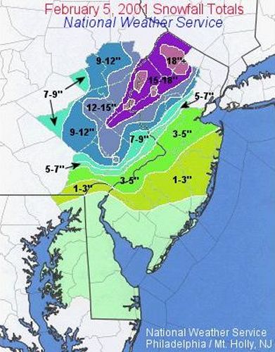
| Snowfall amounts (inches) are taken from reports gathered by the NJ State Climatologist and the National Weather Service (NWS) Offices in Mt. Holly, NJ and Upton, NY. Color Coded snowfall map provided by the NWS in Mt. Holly, NJ. |
Please read our disclaimer.
| SUSSEX |
| STATION | SNOWFALL | TOB |
| Barry Lake |
|
8:00 PM |
| Branchville |
|
8:00 PM |
| Franklin |
|
8:00 PM |
| High Point |
|
Storm |
| Lafayette |
|
8:00 PM |
| Sparta |
|
8:00 PM |
| Stockholm |
|
8:00 PM |
| Sussex Boro |
|
8:00 PM |
| Vernon |
|
8:00 PM |
| Wantage |
|
Storm |
| WARREN |
| STATION | SNOWFALL | TOB |
| Blairstown |
|
8:00 PM |
| Belvidere |
|
8:00 PM |
| Hackettstown |
|
Storm |
| Oxford |
|
9:30 PM |
| Phillipsburg |
|
8:00 PM |
| Stewartsville |
|
Storm |
| Washington Boro |
|
8:00 PM |
| MORRIS |
| STATION | SNOWFALL | TOB |
| Chatham Twp. |
|
Storm |
| Lake Hopatcong |
|
8:00 PM |
| Long Valley |
|
4:00 PM |
| Madison |
|
9:30 PM |
| Marcella |
|
Storm |
| Milton-Oak Ridge |
|
8:00 PM |
| Parsippany |
|
9:30 PM |
| Randolph Twp. |
|
9:30 PM |
| Rockaway |
|
8:00 PM |
| Whippany |
|
8:00 PM |
| PASSAIC |
| STATION | SNOWFALL | TOB |
| Clifton |
|
7:00 PM |
| Hawthorne |
|
Storm |
| Little Falls |
|
11:00 PM |
| North Haledon |
|
Storm |
| Wayne |
|
5:00 PM |
| West Milford |
|
11:45 PM |
| BERGEN |
| STATION | SNOWFALL | TOB |
| Bergenfield |
|
Storm |
| Hasbrouck Heights |
|
7:00 PM |
| Fair Lawn |
|
7:00 PM |
| North Arlington |
|
7:00 PM |
| Rutherford |
|
7:00 PM |
| HUDSON |
| STATION | SNOWFALL | TOB |
| Harrison |
|
7:00 PM |
| Jersey City |
|
7:00 PM |
| Secaucus |
|
7:00 PM |
| ESSEX |
| STATION | SNOWFALL | TOB |
| Livingston |
|
7:00 PM |
| Newark Airport |
|
6:50 PM |
| Nutley |
|
7:00 PM |
| West Caldwell |
|
5:00 PM |
| UNION |
| STATION | SNOWFALL | TOB |
| Cranford |
|
7:00 PM |
| Elizabeth |
|
8:30 PM |
| Union Twp. |
|
6:08 PM |
| HUNTERDON |
| STATION | SNOWFALL | TOB |
| Alexandria |
|
8:00 PM |
| Califon |
|
8:00 PM |
| Flemington |
|
8:00 PM |
| Frenchtown |
|
8:00 PM |
| Kingwood Twp |
|
8:00 PM |
| Lambertville |
|
8:00 PM |
| Lebanon |
|
8:00 PM |
| Neshanic |
|
8:00 PM |
| SOMERSET |
| STATION | SNOWFALL | TOB |
| Belle Mead |
|
Storm |
| Branchburg |
|
8:00 PM |
| Bridgewater |
|
9:30 PM |
| Bridgewater |
|
9:30 PM |
| Raritan |
|
9:30 PM |
| MIDDLESEX |
| STATION | SNOWFALL | TOB |
| Metuchen |
|
Storm |
| Milltown |
|
8:00 PM |
| New Brunswick |
|
Storm |
| Woodbridge Twp. |
|
8:00 PM |
| MERCER |
| STATION | SNOWFALL | TOB |
| Hightstown |
|
Storm |
| Yardville |
|
8:00 PM |
| MONMOUTH |
| STATION | SNOWFALL | TOB |
| Freehold |
|
9:30 PM |
| Middletown |
|
8:00 PM |
| Red Bank |
|
8:00 PM |
| BURLINGTON |
| STATION | SNOWFALL | TOB |
| Bordentown |
|
8:00 PM |
| Browns Mills |
|
8:00 PM |
| Maple Shade |
|
8:00 PM |
| Marlton |
|
8:00 PM |
| Moorestown |
|
8:00 PM |
| Mount Holly |
|
Storm |
| Mount Laurel |
|
8:00 PM |
| OCEAN |
| STATION | SNOWFALL | TOB |
| Toms River |
|
8:00 PM |
| Waretown |
|
8:00 PM |
| CAMDEN |
| STATION | SNOWFALL | TOB |
| Somerdale |
|
8:00 PM |
| GLOUCESTER |
| STATION | SNOWFALL | TOB |
| Glassboro |
|
8:00 PM |
| Swedesboro |
|
8:00 PM |
| Verga |
|
8:00 PM |
| ATLANTIC |
| STATION | SNOWFALL | TOB |
| Absecon |
|
8:00 PM |
| NOTE: TOB is the Time of Observation. |
| Disclaimer: "Storm" indicates that the
report includes snowfall for the entire event. Where time is listed,
it is uncertain whether these are storm totals or incomplete snowfall reports. |
|
Copyright
©2001, Office of the New Jersey State Climatologist, (ONJSC) All rights
reserved. The NJ WxNet, The NJ HomeNet, The NJ Mesonet, and NJ ClimateWatch
are TM by the ONJSC.
|