
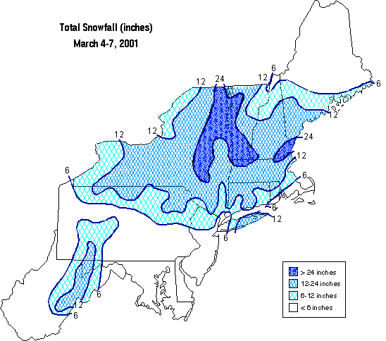
| Snowfall amounts (inches) are taken from reports gathered by the NJ State Climatologist and the National Weather Service (NWS) Offices in Mt. Holly, NJ and Upton, NY. Color Coded snowfall map provided by the NWS in Mt. Holly, NJ. Northeast snowfall map provided courtesy of Keith Eggleston at the Northeast Regional Climate Center. |
Please read our disclaimer.
| SUSSEX |
| STATION | SNOWFALL | TOB |
| Hamburg |
|
4:30 PM (Mar 5) |
| Franklin |
|
4:30 PM (Mar 5) |
| Montague |
|
4:30 PM (Mar 5) |
| Sparta |
|
4:45 PM (Mar 6) |
| Sussex |
|
Storm |
| Sussex Boro |
|
4:30 PM (Mar 5) |
| Vernon |
|
4:30 PM (Mar 5) |
| Wantage |
|
Storm |
| WARREN |
| STATION | SNOWFALL | TOB |
| Belvidere Bridge |
|
Storm |
| Hackettstown |
|
Storm |
| Hardwick |
|
4:30 PM (Mar 5) |
| MORRIS |
| STATION | SNOWFALL | TOB |
| Chatham Twp. |
|
Storm |
| Long Valley |
|
Storm |
| Marcella |
|
Storm |
| Oak Ridge |
|
9:30 PM (Mar 6) |
| Rockaway Twp. |
|
4:45 PM (Mar 6) |
| PASSAIC |
| STATION | SNOWFALL | TOB |
| Clifton |
|
9:00 PM (Mar 5) |
| Greenwood Lake |
|
Storm |
| West Milford |
|
10:00 AM (Mar 6) |
| BERGEN |
| STATION | SNOWFALL | TOB |
| Cliffside |
|
8:00 PM (Mar 6) |
| Bergenfield |
|
Storm |
| Fair Lawn |
|
Storm |
| Hasbrouck Hts. |
|
11:50 AM (Mar 6) |
| North Arlington |
|
11:10 AM (Mar 6) |
| Ramsey |
|
12:00 AM (Mar 6) |
| Teterboro Airport |
|
7:30 PM (Mar 6) |
| HUDSON |
| STATION | SNOWFALL | TOB |
| Harrison |
|
Storm |
| Hoboken |
|
2:00 PM (Mar 6) |
| Jersey City |
|
2:00 PM (Mar 6) |
| Rutherford |
|
2:00 PM (Mar 6) |
| Secaucus |
|
2:00 PM (Mar 6) |
| ESSEX |
| STATION | SNOWFALL | TOB |
| Newark Airport |
|
Storm |
| West Caldwell |
|
10:00 AM (Mar 6) |
| UNION |
| STATION | SNOWFALL | TOB |
| Elizabeth |
|
Storm |
| Watchung |
|
7:30 AM (Mar 6) |
| HUNTERDON |
| STATION | SNOWFALL | TOB |
| Lambertville |
|
4:00 PM (Mar 5) |
| SOMERSET |
| STATION | SNOWFALL | TOB |
| Belle Mead |
|
Storm |
| Somerville |
|
Storm |
| MIDDLESEX |
| STATION | SNOWFALL | TOB |
| Metuchen |
|
Storm |
| New Brunswick |
|
Storm |
| MERCER |
| STATION | SNOWFALL | TOB |
| Hightstown |
|
Storm |
| BURLINGTON |
| STATION | SNOWFALL | TOB |
| Mount Holly |
|
Storm |
| CAMDEN |
| STATION | SNOWFALL | TOB |
| Somerdale |
|
Storm |
| ATLANTIC |
| STATION | SNOWFALL | TOB |
| Atlantic City |
|
4:45 PM (Mar 6) |
| Estell Manor |
|
Storm |
| NOTE: TOB is the Time of Observation. |
| Disclaimer: "Storm" indicates that the
report includes snowfall for the entire event. Where time is listed,
it is uncertain whether these are storm totals or incomplete snowfall reports. |
|
Copyright
©2001, Office of the New Jersey State Climatologist, (ONJSC) All rights
reserved. The NJ WxNet, The NJ HomeNet, The NJ Mesonet, and NJ ClimateWatch
are TM by the ONJSC.
|