
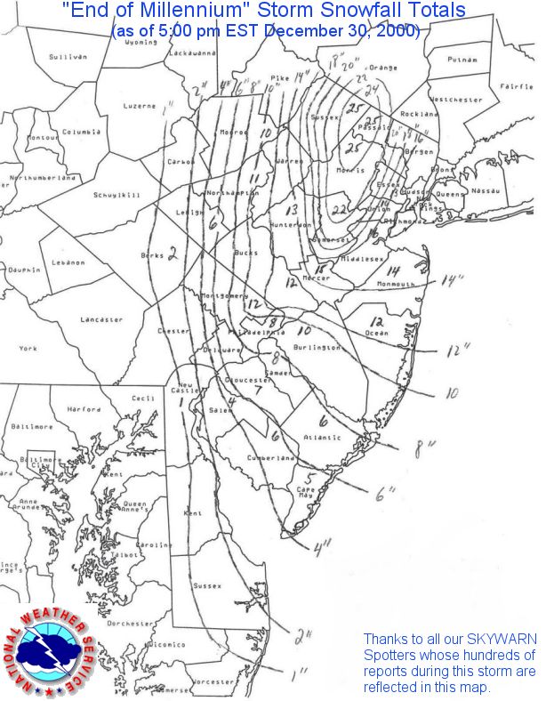
| Snowfall amounts (inches) are taken from reports gathered by the NJ State Climatologist and the National Weather Service (NWS) Offices in Mt. Holly, NJ and Upton, NY. Snowfall Map provided by the NWS in Mt. Holly, NJ. |
Please read our disclaimer.
| SUSSEX |
| STATION | SNOWFALL | TOB |
| Franklin | 3:30 PM | |
| Green Township | 4:45 PM | |
| Hamburg | 4:45 PM | |
| Highland Lakes | 4:45 PM | |
| Lake Stockholm | 1:00 PM | |
| Libertyville | 4:45 PM | |
| Montague | 3:30 PM | |
| Newton | 4:45 PM | |
| Sparta |
|
3:30 PM |
| Stanhope | 4:45 PM | |
| Stillwater | 3:30 PM | |
| Stockholm | 3:30 PM | |
| Sussex | Storm | |
| Vernon | 4:45 PM | |
| Wantage | Storm | |
| Mt. Creek | Storm | |
| Vernon | Storm |
| WARREN |
| STATION | SNOWFALL | TOB |
| Stewartsville | Storm | |
| Belvidere Bridge | Storm | |
| Washington | 4:45 PM |
| MORRIS |
| STATION | SNOWFALL | TOB |
| Boonton | 4:45 PM | |
| Long Hill Twn. | 3:30 PM | |
| Long Valley | 4:45 PM | |
| Madison | 3:30 PM | |
| Marcella | Storm | |
| Chatham Twn. | Storm | |
| Milton | 8:00 PM | |
| Montville | 3:30 PM | |
| Morris Plains | 3:30 PM | |
| Morris Twn. | 4:45 PM | |
| Randolph | 4:45 PM | |
| Rockaway | 4:45 PM |
| PASSAIC |
| STATION | SNOWFALL | TOB |
| Hawthorne | Storm | |
| Pompton Lakes | 5:30 PM | |
| Clifton | 5:30 PM | |
| Greenwood Lake | Storm | |
| Hewett | 4:30 PM | |
| Wayne | Storm |
| BERGEN |
| STATION | SNOWFALL | TOB |
| Rutherford | 5:30 PM | |
| Lyndhurst | 5:30 PM | |
| Palisades Park | 5:30 PM | |
| Teterboro AP | 6:50 PM | |
| Ramsey | 4:00 PM | |
| Fair Lawn | 4:30 PM | |
| Hasbrouck Hts. | 5:30 PM | |
| North Arlington | 5:30 PM |
| HUDSON |
| STATION | SNOWFALL | TOB |
| Harrison | 5:30 PM | |
| Jersey City | 5:30 PM | |
| Secaucus | 5:30 PM | |
| Kearny | 7:15 PM | |
| Union City | 4:30 PM | |
| Hoboken | 5:20 PM |
| ESSEX |
| STATION | SNOWFALL | TOB |
| Newark AP | Storm | |
| West Caldwell | 4:50 PM | |
| Nutley | 5:00 PM |
| UNION |
| STATION | SNOWFALL | TOB |
| Elizabeth | Storm |
| HUNTERDON |
| STATION | SNOWFALL | TOB |
| Alexandria | 1:00 PM | |
| Annadale | 3:30 PM | |
| Clinton | 1:00 PM | |
| Flemington | 1:00 PM | |
| Frenchtown | 1:00 PM | |
| Tewksbury | 1:00 PM | |
| Whitehouse | 1:00 PM | |
| Wertsville | Storm |
| SOMERSET |
| STATION | SNOWFALL | TOB |
| Basking Ridge | 4:45 PM | |
| Belle Mead | Storm | |
| Bound Brook | 3:30 PM | |
| Bridgewater | 3:30 PM | |
| Hillsborough | 3:30 PM | |
| North Plainfield | 3:30 PM | |
| Raritan | 3:30 PM | |
| Somerset | 8:00 PM | |
| Somerville | 8:00 PM |
| MIDDLESEX |
| STATION | SNOWFALL | TOB |
| Metuchen | Storm | |
| Milltown | 8:00 PM | |
| New Brunswick | Storm | |
| Old Bridge | 3:30 PM | |
| Woodbridge | 8:00 PM |
| MERCER |
| STATION | SNOWFALL | TOB |
| East Windsor | 3:30 PM | |
| Hightstown | Storm | |
| Princeton | 3:30 PM | |
| Titusville | 3:30 PM | |
| Washington Cros. | 3:30 PM | |
| Yardville | 1:00 PM |
| MONMOUTH |
| STATION | SNOWFALL | TOB |
| Aberdeen | 1:00 PM | |
| Belmar | 1:00 PM | |
| Hazlet | 4:45 PM | |
| Howell | 3:30 PM | |
| Long Branch | 3:30 PM | |
| Marlboro | 4:45 PM | |
| Middletown | 3:30 PM | |
| Millstone | 3:30 PM | |
| Neptune | 4:45 PM | |
| Ocean Grove | 1:00 PM | |
| Oceanport | 1:00 PM | |
| Red Bank | 3:30 PM | |
| Wall Township | 3:30 PM | |
| W. Long Branch | 1:00 PM |
| BURLINGTON |
| STATION | SNOWFALL | TOB |
| Bordentown | 8:00 PM | |
| Browns Mills | 8:00 PM | |
| Maple Shade | 1:00 PM | |
| Moorestown | 3:30 PM | |
| Mount Holly | Storm | |
| Palmyra | 3:30 PM | |
| Wrightstown | 8:00 PM |
| OCEAN |
| STATION | SNOWFALL | TOB |
| Bayville | 1:00 PM | |
| Brick Township | 3:30 PM | |
| Jackson | 8:00 PM | |
| Point Pleasant | 8:00 PM |
| CAMDEN |
| STATION | SNOWFALL | TOB |
| Cherry Hill | Storm | |
| Haddonfield | 1:00 PM | |
| Haddon Heights | 1:00 PM | |
| Lindenwold | 8:00 PM | |
| Somerdale | 8:00 PM |
| GLOUCESTER |
| STATION | SNOWFALL | TOB |
| Franklinville | 1:00 PM | |
| Glassboro | 8:00 PM | |
| Swedesboro | 8:00 PM | |
| Williamstown | 8:00 PM |
| ATLANTIC |
| STATION | SNOWFALL | TOB |
| Absecon | 1:00 PM | |
| Atlantic City AP | 8:00 PM | |
| Estelle Manor | Storm | |
| Margate | 4:45 PM |
| SALEM |
| STATION | SNOWFALL | TOB |
| Pennsville | 3:30 PM | |
| Salem | 3:30 PM |
| CUMBERLAND |
| STATION | SNOWFALL | TOB |
| Bridgeton | 3:30 PM | |
| Vineland | 3:30 PM |
| NOTE: TOB is the Time of Observation. |
| Disclaimer: "Storm" indicates that the
report includes snowfall for the entire event. Where time is listed,
it is uncertain whether these are storm totals or incomplete snowfall reports. |
|
Copyright
©2001, Office of the New Jersey State Climatologist, (ONJSC) All rights
reserved. The NJ WxNet, The NJ HomeNet, The NJ Mesonet, and NJ ClimateWatch
are TM by the ONJSC.
|