Typical Springtime Variability: May and Spring 2014 Summaries
New Jersey State Climatologist
Center for Environmental Prediction, School of Environmental and Biological Sciences/NJAES, Rutgers University
June 6, 2014
May Overview
May 2014 had a difficult time establishing an identity. What began with a storm that carried over from April 30th and resulted in the 7th largest flood of the past century in the Raritan basin on the 1st (see the April narrative for discussion of this event), later included some warm days, late freezes in a few locations, severe thunderstorms with hail in others, and a spectacular Memorial Day. Overall, May averaged 62.1°, which is 1.3° above average (compared to the 1981-2010 average). This ranks as the 35th warmest (tied with 1962) in the 120 years back to 1895. Precipitation averaged 5.18", which is 1.18" above average and ranks as 19th wettest. This value includes the considerable rain that fell on April 30th at National Weather Service Cooperative Stations that report during the morning hours (see April narrative for a full explanation).
Precipitation and storms
There was almost a factor of three difference between the wettest and driest location in NJ in May. Kearny (Hudson County) led the way with 10.86", followed by North Arlington (Bergen) 9.53", Hamilton (Mercer) 8.86", Robbinsville (Mercer) 8.61", and East Greenwich (Gloucester) 8.45". Middle Township (Cape May) came up shortest with 3.22", followed by the Cape May County communities of Wildwood Crest 3.34" and Woodbine 3.39".
Flooding subsided rather quickly following river crests on the 1st. Local thundershowers on the 4th deposited some pea-size hail at Wantage (Sussex) and Ringwood (Passaic). Little rain fell until the evening of the 7th into the morning of the 8th, when the northern and central coast saw the most with 1.03" in Long Branch (Monmouth) and 1.02" at both Eatontown (Monmouth) and Stafford Township (Ocean). The least rain fell in southwest counties. The 9th dawned with scattered moderate to dense fog, later to be followed by rain that was off and on from late on the 9th until early on the 11th. Thunderstorms during the evening of the 10th brought down trees and wires in portions of Hunterdon, Burlington, Somerset, and Bergen counties, including a tree that fell onto a car in Fairview (Bergen). Central and northeastern areas saw 0.10" to 0.50", with as much as 0.74" in Bedminster (Somerset), 0.71" at Hamilton (Mercer), and 0.70" at Glen Rock (Bergen). Less than 0.10" accumulated in the southeast and far northwest.
Late evening rain on the 12th into the early 13th was widely scattered in central and south Jersey. As much as 0.50" fell at Lavallette (Ocean), with 0.39" and 0.34" at two Montgomery (Somerset) locations. Most locations received under 0.10". Bergen County saw moderate rain late on the 14th into early on the 15th. While less than 0.10" fell elsewhere in NJ, Ramsey saw 0.60" and Glen Rock 0.47".
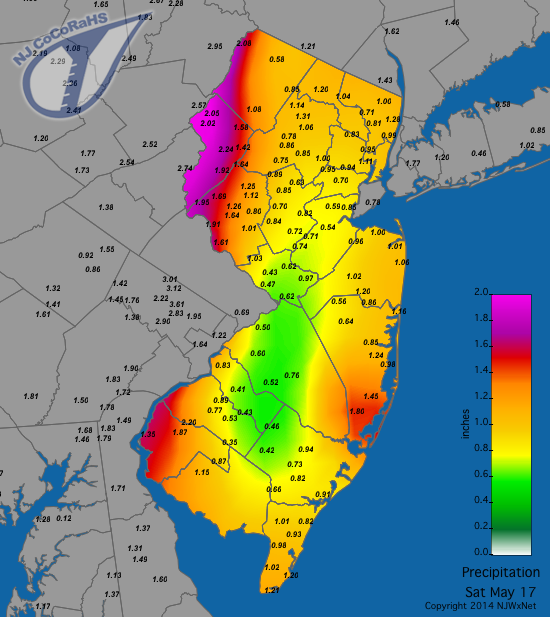
A storm from the morning of the 16th into early hours of the 17th brought heavy rain to western and eastern regions and a lighter zone up the middle of the state. This is depicted in Figure 1, with Warren County reports of 2.95" in Mansfield, Liberty Township 2.84", and Blairstown 2.57". Of approximately 200 NJ CoCoRaHS reports, 12 equaled or exceeded 2.00" and 82 were between 1.00" and 1.99". Franklin Township (Gloucester) saw the least with 0.35".
Figure 1
|
|---|
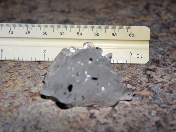
Rain fell from dawn on the 22nd into the early hours of the 23rd. Scattered areas of Mercer County southeast into Ocean County saw over 2.00", including Pine Beach (Ocean) with 2.68", and both Hamilton Township (Mercer) and Berkeley Township (Ocean) with 2.21". Severe storms dropped hail in several locations. It was as large as ping-pong balls in Upper Deerfield and Fairfield Township (both in Cumberland), quarter-size in Woodstown (Salem) and Woolwich (Gloucester), and pea to quarter size in Blairstown (Warren) and Randolph (Morris). Elsewhere, rain totaled less than 0.25", especially in the northeast, while a few areas in the southwest and northwest saw over an inch.
Figure 2
|
|---|
The northeast quarter of the state was targeted by strong thunderstorms during the afternoon and evening hours of the 23rd. This included 2.39" in Kearny (Hudson), 2.20" at North Arlington, and 2.14" in Tenafly. Pea to marble size hail fell in River Vale (Bergen), Vernon Township (Sussex), Little Falls (Passaic), and Kenilworth (Union). Further south, pea-size hail fell in Moorestown (Burlington) and Little Egg Harbor (Ocean). Flash flooding occurred on some northeast roadways, while elsewhere less than 0.10" fell in central and southern NJ. Showers returned during the second half of the 24th. A wedge-shaped zone extending from the Mercer-Middlesex border north to Sussex and Bergen saw up to 0.50" in most locations, except for 0.96" in Peapack-Gladstone (Somerset), 0.86" in Bedminster (Somerset), and 0.73" at Oakland (Bergen).
Continuing the sure sign that warm-season convective systems had begun to provide the bulk of our rainfall, yet another afternoon and evening bout of scattered thunderstorms invaded the southern half of NJ on the 27th. While totals were mainly under 0.50", 1.10" fell at Runnemede (Camden), 1.00" at Washington Township (Gloucester), and 0.74" in Dennis Township (Cape May). Gusty winds damaged trees and wires in portions of Burlington and Monmouth counties. Daytime showers on the 28th deposited 2.40" in Franklin Township (Gloucester), 1.58" in Folsom (Atlantic), and 1.36" at Clayton (Gloucester). The distribution of rainfall was almost identical to that of the previous day, including little to none in central and northern NJ. However larger amounts fell in Camden, Gloucester, and Atlantic than on the 27th.
The highest barometric pressure of May occurred on the 14th, with values close to 30.35". The lowest pressures of between 29.60"-29.65" occurred on the 1st and 4th. On six May days, winds gusted to 40 mph or greater at NJWxNet stations. On the 4th, High Point Monument (Sussex) topped out at 44 mph, with six other stations between 40-43 mph. Wantage (Sussex) reached 47 mph on the 5th. A local storm brought a 42 mph gust to Lyndhurst (Bergen) on the 10th. The 16th was the windiest day of May, with Stewartsville (Warren) and Wantage up to 46 mph, Berkeley Township (Ocean) 44 mph, and Upper Deerfield (Cumberland) 42 mph. Twenty other stations gusted between 30-39 mph. Berkeley Township gusted to 54 mph on the 22nd and Upper Deerfield 48 mph. On the 27th, Harvey Cedars (Ocean) and Mullica (Atlantic) hit 43 mph and Seaside Heights (Ocean) 40 mph.
Temperature
Maximum temperatures equaled or exceeded 80° on nine May afternoons at one or more of the 53 NJWxNet stations where temperatures were observed. The first such occurrence was on the 10th, when Egg Harbor Township (Atlantic) and West Creek (Ocean) reached 85°. The 11th saw Jersey City (Hudson) up to 83°. Red Lion (Burlington) hit 89° and Cherry Hill (Camden), Howell (Monmouth), and Sicklerville (Camden) reached 88° on the 12th. Greenwich (Cumberland) was 83° on the 13th and Cherry Hill, Clayton (Gloucester), and Sewell (Gloucester) 82° on the 15th. Jersey City made it to 80 and on the 20th. The warmest three-day spell of the month surrounded Memorial Day (26th). Five stations reached 83° on the 25th. A remarkable convergence of maximum temperatures occurred on Memorial Day, when 15 stations maxed out at 87°, 12 at 86°, and 12 at 85°. The coolest location was the Atlantic City Marina (Atlantic) at 77°. The 27th was the warmest day of May, with the first 90° readings of the season at NJWxNet stations recorded at Cape May Courthouse (Cape May), Oswego Lake (Burlington), West Creek, and Woodbine (Cape May), which all topped out at 90°. The cool spot was Netcong (Morris) at 81°.
Eight May days saw temperatures bottom out below 40° at one or more stations. Pequest (Warren) fell to 39° on the 2nd, Walpack (Sussex) to 33° on the 3rd, and Pequest to 37° on the 5th. West Creek reached 31° on the 6th, when Walpack fell to 33°. These two stations dropped to 30° and 29°, respectively, on the 7th, joined by Pequest at 32°. The last trio of cool mornings began on the 18th, with Pequest down to 36°. The last subfreezing temperatures of May, and likely the season, occurred on the 19th, when Walpack was 31° and Pequest 32°. These two stations dropped to 35° on the 20th.
Assuming the freezing season has ended, a look at NJWxNet stations shows a 103-day difference to the length of the season between several stations. Walpack had its first freeze on September 24th and the last on May 19th for a 238-day season. Pequest went from October 19th to May 19th for second longest at 213 days. On the other end, both Atlantic City Mariana (Atlantic) and West Cape May (Cape May) did not see their first freeze until November 13 and experienced the last freezing day on March 27th for a 135-day season. Only a day behind was Harvey Cedars (Ocean) with a range from November 12th to March 27th.
Spring Overview
Spring (March-May) temperatures were on the cool side, averaging 49.3°. This is 1.7° below average and ranks as the 42nd coolest since 1895. The front end of the season was quite chilly, with March 5.8° below average. April was just below average (0.6°), while May pulled up the seasonal average at bit at +1.3°. The coldest temperature of the season was -9° on March 4th at Walpack (Sussex), the warmest 90° at four locations on May 27th.
Spring precipitation across the state average 13.38". This is 0.88" above average and ranks as the 28th wettest. There were two major rainstorms during the season. The first, from March 29th-31st, deposited as much as 3.75" at North Brunswick (Middlesex). The second, from April 29th-May 1st, saw as much as 6.52" in Washington Township (Gloucester). This resulted in the 7th largest flood of the past 80 years occurring at several stream gauges in the Raritan basin of central NJ and considerable roadway and stream flooding elsewhere.
Snowfall was abundant in southern NJ during March, but virtually nonexistent in central and north reaches. Three storms contributed to a monthly total of 21.8" at Wildwood Crest (Cape May). April saw a late season light snow event from the 15th into the 16th, with 1.5" falling in Freehold (Monmouth) and 1.3" at High Point (Sussex).
For those seeking more detailed information on hourly, daily and monthly conditions, please visit the following Office of the NJ State Climatologist's websites:
NJ Weather and Climate Network
NJ Community Collaborative Rain, Hail and Snow Network
NJ Snow Event Reports
Interested in receiving our monthly summaries at the end of each month? Send us your e-mail address here to join the mailing list.
Past Climate Summaries

