Up and Down But in the End Quite Average: September 2020 Recap
New Jersey State Climatologist
Center for Environmental Prediction, School of Environmental and Biological Sciences/NJAES, Rutgers University
October 6, 2020
Overview
September 2020 was a month of widely-varying temperatures, several episodes of heavy precipitation, and an extended dry spell. Put it all together and conditions averaged quite close to normal. The statewide monthly average temperature of 66.8° was 1.0° above the 1981–2010 mean. While it was the seventh month of 2020 to average above normal, it was just the second of these not to rank in the top 10 for warmth. Rather, it ranked 33rd warmest of the past 126 Septembers. Divisional departures from normal ranged from +0.7° in the north to +1.5° along the coast. The statewide average maximum temperature was 76.6°, which is 0.3° above normal and ranks 47th warmest. The average minimum of 56.9° was 1.6° on the warm side and ranked 24th mildest. High temperatures were likely reduced by several degrees during a mid-month period when a veil of smoke from western US forest fires blanketed the sky at an altitude of about 25,000–30,000 feet when skies otherwise would have been blue, especially on the 15th–16th. It is uncertain if this kept minimum temperatures somewhat warmer than they would otherwise have been. A cold front moved through from the northwest on the 18th, clearing the skies and sending temperatures plummeting. What followed was a four-day spell of temperatures that were well below average, including four nights with below-freezing temperatures at three to four Rutgers NJ Weather Network sites. While freezes resulting from cold air draining into valleys in some northern locations are not unprecedented before the end of astronomical summer, it is highly unusual for the cold to persist over four consecutive nights.
Precipitation averaged 4.17”, which was 0.12” above normal, ranking 44th wettest. The north division was driest at 3.76”, which is 0.71” below average and ranks 59th wettest (68th driest). The south averaged 4.38”, which is 0.56” above average and ranks 34th wettest. While somewhat above average, Figure 1 shows that this division included a very dry north and quite wet south (the division includes Mercer, Middlesex, and Monmouth counties and all others to the south, except for a narrow coastal division). The coastal division received 4.82” giving it a departure of +1.25” and a ranking of 23rd wettest. The vast majority of the monthly precipitation fell in events on the 2nd–3rd, 9th–10th, and 29th–30th. None of these stemmed from tropical activity, while two smaller events were associated with the remnants of tropical storms Sally and Beta. Dry weather was the norm from the 11th–27th, with some northern and central locations not receiving measurable precipitation during this 17-day period.
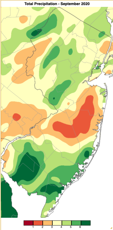
Figure 1. September 2020 precipitation across New Jersey based on a PRISM analysis generated using NWS Cooperative and CoCoRaHS observations (Oregon State University). The three shades of orange/yellow (1.00” to 4.00”) received below-average precipitation, while the three shades of green (4.00” to 7.00”) were above normal.
Temperature
The maximum temperature reached 80° to 90° at one or more of the 63 NJWxNet stations on 19 September days. This included seven days with highs at or above 85°. The first was on the 2nd, with Piney Hollow (Gloucester County) and Sicklerville (Camden) hitting 88° and 51 other stations from 80°–87°. The two warmest days of the month followed, with Piney Hollow, Red Lion (Burlington), and Sicklerville each up to 90° on the 3rd and 57 stations from 80°–89°. Sicklerville, West Creek (Ocean), and Lower Alloways Creek (Salem) rose to 90° on the 4th, and 56 stations maxed out at 80°–89°. On the low end of the spectrum, Vernon (Sussex) got to 78° on the 3rd and three stations to just 77° on the 4th.
Four stations made it to 86° on the 6th, and Hamilton (Mercer), Cherry Hill (Camden), and Mansfield (Burlington) reached 85° on the 7th. West Deptford (Gloucester) came out on top at 88° on the 8th, with 54 stations from 80°–87°. Basking Ridge (Somerset), Mansfield, and Moorestown (Burlington) got to 85° on the 10th. The last warm day of the month was the 28th, with four stations up to 84° followed closely by 33 sites from 80°–83°.
Eleven September days were cool enough to see minimums of 45° or cooler at one or more NJWxNet sites. All occurred consecutively from the 14th–24th and included five mornings with a state minimum at or below 35°. The first of these was on the 15th when Walpack (Sussex) fell to 35°. Next up on the 19th Walpack reached 29°, Sandyston (Sussex) 31°, and Pequest (Warren) 32°. Walpack bottomed out at 31° and Sandyston and Pequest 32° on the 20th. The 21st had freezes at Sandyston with 28°, Walpack and Pequest each 29°, and Basking Ridge 30°. Twenty stations fell to 33°–39° on the 20th, while Harvey Cedars (Ocean) owed their low of only 55° to the surrounding mild bay and ocean waters (Figure 2). Sandyston again dropped to 28° on the 22nd, followed by Pequest and Basking Ridge each at 30° and Walpack 31°. Meanwhile, 27 stations fell to 34°–39°, and coastal Harvey Cedars and Seaside Heights (Ocean) each reached their monthly low of 50°. The highest barometric pressure of the month was associated with this cold air mass, ranging from 30.55”–30.60” on the 21st.
The first fall freezes on the 19th marked the end of the growing season at these locations. Walpack experienced a late spring freeze on June 1st, leaving this location with a short 109-day season. Contrast that with several coastal locations that last saw a freeze on March 1st, thus by the end of September remained in the midst of a growing season of 213 days….and counting.
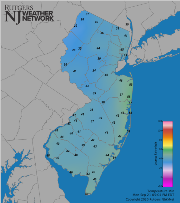
Figure 2. Minimum temperatures on the morning of September 21st showing a range from 28° in Sandyston to 59° in Harvey Cedars (which fell 55° late in the evening to reach a lower daily minimum than shown here). Reports are from the Rutgers NJ Weather Network.
Precipitation and Storms
As with last month, there was an over five-fold difference between the wettest and driest location in NJ during September. In fact, it was just over six times wetter at Pittsgrove (Salem) than at Berkeley Township (Ocean). The former came in with 8.04”, followed by Upper Deerfield (Cumberland) with 7.86”, Millville (Cumberland) 7.78”, Fairfield Township (Cumberland) 7.63”, South Harrison (Gloucester) 7.53”, and Pennington (Mercer) 7.49” and 6.98”. Berkeley Township only managed 1.33”, followed by Howell (Monmouth) with three stations from 1.36”–1.73”, Toms River (Ocean) 1.63”, Freehold (Monmouth) 1.78”, Manchester (Ocean) 1.78”, and Pennsville in far western Salem County with 2.09”.
The first wet episode of the month was a double-barrel one. It began late on the 2nd continuing into the first half of the 3rd. The northwest corner of the state saw the most, with the Sussex County locations of Stillwater (2.78”), Branchville (2.28”), Montague (2.12”), and Franklin (1.70”) seeing the most (Figure 3). Rain recommenced during the evening of the 3rd, with thunderstorms impacting central areas the most, including some downed trees and wires in Mercer County. Mercer County stations caught the most rain, including Pennington with 2.45” and 2.03” at two locations, Princeton with four stations from 2.20” to 2.44” and another only catching 1.02”, and West Windsor with 2.39” (Figure 4). Scattered locations to the north and far south saw over 0.50”.
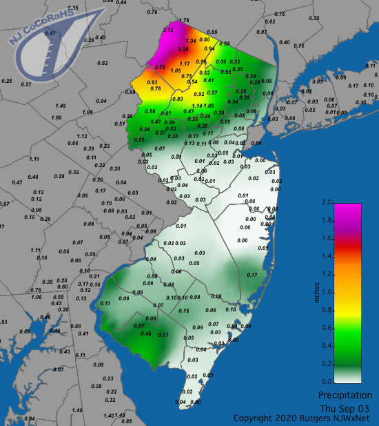
Figure 3. Rainfall from approximately 7AM on September 2nd to 7AM on September 3rd. Reports are from CoCoRaHS observers.
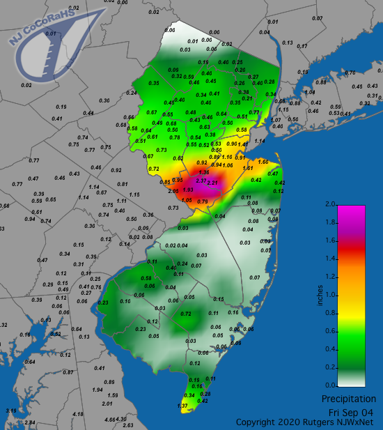
Figure 4. Rainfall from approximately 7AM on September 3rd to 7AM on September 4th. Reports are from CoCoRaHS observers.
A number of locations throughout NJ received over an inch of rain from late in the evening of the 9th through early on the 10th and then from thunderstorms during the evening of the 10th (Figures 5 and 6). Some southern locations were soaked during both intervals of heavy rain, resulting in Ocean City (Cape May) accumulating 6.02”. Other hefty totals included three Woodbine (Cape May) stations with 5.00”–5.90”, Atlantic City Marina (Atlantic) 4.78”, Middle Township (Cape May) 4.77”, Galloway (Atlantic) 4.73”, Brigantine (Atlantic) 4.66”, and the Atlantic City Airport in Pomona (Atlantic) 4.65”. Of 256 CoCoRaHS reports, 16 saw 4.00” or more, 22 from 3.00”–3.99”, 36 from 2.00”–2.99”, and 88 from 1.00”–1.99”.
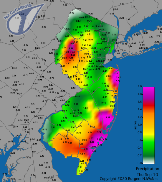
Figure 5. Rainfall from approximately 7AM on September 9th to 7AM on September 10th. Reports are from CoCoRaHS observers.
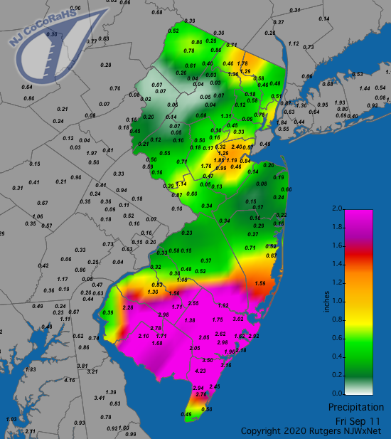
Figure 6. Rainfall from approximately 7AM on September 10th to 7AM on September 11th. Reports are from CoCoRaHS observers.
Moisture from the remnants of Tropical Storm Sally brought rain to the Garden State south of the Interstate 195 corridor during the late afternoon of the 18th until early on the 19th (Figure 7). Three Lower Township (Cape May) stations saw 0.61” to 0.74” and Wildwood Crest 0.70”.
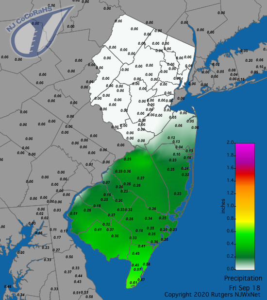
Figure 7. Rainfall from approximately 7AM on September 17th to 7AM on September 18th. This shows rainfall associated with the remnants of Tropical Storm Sally. Reports are from CoCoRaHS observers.
Morning rain on the 26th delivered over an inch to the southwest locations of Greenwich (Cumberland) 1.11”, Mannington (Salem) 1.08”, and Lower Alloways Township 1.05”. Scattered showers during the afternoon of the 27th to early on the 28th were loosely associated with the remnants of Tropical Storm Beta, with a circulation pattern seen in clouds over the Atlantic east of Delaware Bay. Clinton and Lebanon, each in Hunterdon County, caught 0.51” and 0.49”, respectively, and South Harrison saw 0.48”.
Scattered afternoon showers on the 29th transitioned to several intervals of heavy rain during the evening and early on the 30th as moisture moved from south to north (Figure 8). The heaviest amounts fell in South Harrison with 4.17”, Pitman (Gloucester) 3.53”, Moorestown 3.51”, Wenonah (Gloucester) 3.51”, Mount Laurel (Burlington) 3.46”, and Fairfield Township 3.33”. Of 267 CoCoRaHS reports, 22 eclipsed 3.00”, 94 were from 2.00”–2.99”, and 100 from 1.00”–1.99”. Coastal areas saw the least, with Wildwood Crest only measuring 0.34”. This event included the lowest barometric pressures of the month across the state, ranging from 29.45”–29.55”. As a result, the only 40+ mph gusts seen at NJWxNet stations in September were recorded at Berkeley Township and Harvey Cedars, each gusting to 47 mph, High Point Monument (Sussex) 43 mph, Point Pleasant (Ocean) 41 mph, and Fortescue (Cumberland) 40 mph.
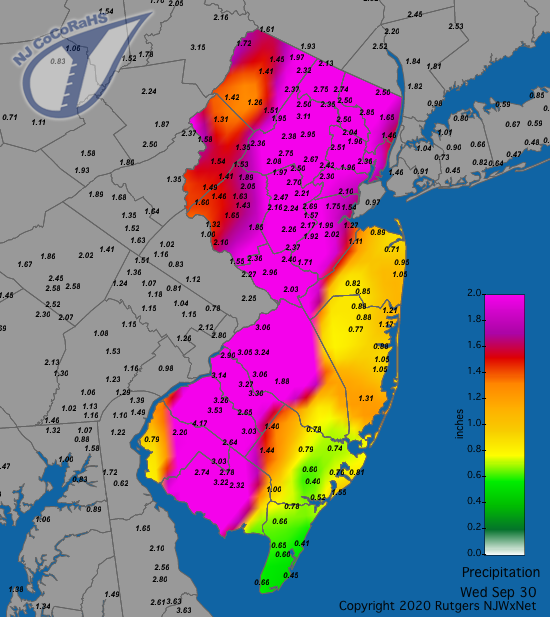
Figure 8. Rainfall from approximately 7AM on September 29th to 7AM on September 30th. Reports are from CoCoRaHS observers.
For those seeking more detailed information on 5-minute, hourly, daily, and monthly conditions, please visit the following Office of the NJ State Climatologist's websites:
Rutgers NJ Weather Network
NJ Community Collaborative Rain, Hail and Snow Network
NJ Snow Event Reports
Interested in receiving our monthly summaries at the end of each month? Send us your e-mail address here to join the mailing list.
Past News Stories

