

Another End-of-Month Soaker…but First Some Flames: April 2014 Summary
New Jersey State Climatologist
Center for Environmental Prediction, School of Environmental and Biological Sciences/NJAES, Rutgers University
May 10, 2014
Was it a drier-than-average April? Was it a wetter-than-average April? If only it hadn't rained heavily on the last day of the month! Certainly this is a strange beginning to this monthly weather narrative. Let me explain before we get to the numbers. Most National Weather Service Cooperative observers, of which there are several dozen in New Jersey, take their daily observations in the 7-8 AM time range. So does nearly every NJ CoCoRaHS observer. These observations are recorded for the calendar day at hand, thus a day's weather records are complete as of the observation time. This means that any precipitation that occurs after the daily observation gets recorded the next morning (day). This is something that must be understood when evaluating daily precipitation reports, however, it does not make any difference in monthly totals except on the first and last day of the month. One of these exceptions occurred, in a big way, in April…or was it May?! Torrential rain fell during the daylight hours into the evening of April 30, part of an event that began lightly during the daylight hours of the 29th and ended just after observation time on the morning of May 1st (yes, meaning May 2 observations also were involved in storm totals). What up until then had been a somewhat dry April suddenly became a wet month…if you waited until midnight to take your observations. And believe it or not, some COOP stations do have observations taken at midnight. Confused? Can't blame you…
To remain an official part of the historical record, April statewide precipitation averages from COOP stations must be true to the observation time rules. April 2014 precipitation averaged 3.95" across NJ, which is 0.11" below the 1981-2010 average and ranks as the 44th wettest April since 1895. The April total includes modest rain that fell before the morning of the 30th and more substantial totals from the several midnight stations that accumulated multiple inches of rain throughout the 30th. Thus, official May 2014 precipitation totals got off to a very wet start at most stations, as will be reported in several weeks. However, rather than wait to report on this rain storm and the major flooding that accompanied it over portions of NJ, the event will be discussed later in this narrative.
The observation time issue is not nearly as potentially significant for monthly temperatures, though extreme temperatures on the last day of a month can skew averages slightly. This was not the case in April, and the statewide temperature for the month averaged 50.8°. This is 0.4° below average and ranks as the 44th warmest April on record. The January through April average temperature is 35.5°. This is 3.8° below the 1981-2010 average and ranks as the 16th coolest start to the year since 1895 (tied with 1923 and 1899).
Precipitation and storms
The northwest portion of the state was wettest in April, and the far south coast driest. Again excluding any rain after 7-8 AM on the 30th, Washington Township (Morris County) received the most moisture in April with 5.27". Lebanon (Hunterdon), Jefferson Township (Morris), and Mine Hill Township follow close behind, all at 5.12". The Cape May County communities of Sea Isle City at 2.08" and Middle Township 2.36" received the least rain, with Upper Deerfield (Cumberland) at 2.40" and Woodbine (Cape May) next in line at 2.57".
The first event of the month occurred from the evening of the 3rd into early on the 5th. A maximum of 0.57" fell in Westfield (Union), with Blairstown (Warren) second at 0.54". Several tenths of an inch was common north of I-78, with on a few hundredths south of I-195. Next up was a quick hitting episode of rain from late on the 7th into the morning of the 8th. Ocean Township (Monmouth) received 0.98", Harrison (Hudson) 0.96", and Mt. Laurel (Burlington) 0.94". Totals of 0.30" to 0.80" were common across NJ.
A soaking rain fell throughout NJ during the daytime hours of the 15th into the pre-dawn hours of the 16th, making this the wettest event of the month…that didn't include the daytime or evening of the 30th! Some late season snow and sleet also fell. The northwest corner of the state received the most precipitation (rain and melted snow/sleet), including 2.53" in Bethlehem Township (Hunterdon), 2.53" at Washington (Warren), and 2.51" in Frenchtown (Hunterdon). Over 1.25" fell in Hunterdon, Warren, Sussex, Morris, northern Passaic, and northern Somerset counties. The remainder of NJ caught between 0.75"-1.25", although Pine Beach (Ocean) only received 0.46", Piscataway (Middlesex) 0.51", and Kearny (Hudson) 0.55". Conditions were cold enough during the evening to early morning hours to deposit varying light amounts of snow and sleet over central and northern areas. Scattered areas received measurable amounts, including 1.5" at Freehold (Monmouth), 1.3" at High Point (Sussex), 0.8" in Howell (Monmouth) and Randolph (Morris), and 0.7" in Cedar Grove (Essex) and Jefferson Township (Morris). The 0.2" of snow in New Brunswick (Middlesex) was the third latest measurable spring snow dating back to 1893.
Late on the 25th into the pre-dawn hours of the 26th saw statewide rainfall mostly ranging from several tenths to three quarters of an inch. Top honors went to Wall Township (Monmouth) with 0.92", Hardyston (Sussex) 0.91", and Brick Township (Ocean) 0.88".
The end-of-month storm began with light rain during the midday hours of the 29th and ended after dawn on May 1st. As mentioned previously, the heaviest rain fell during the daylight hours of the 30th into the evening. The map below depicts the distribution of the rainfall, including a broad swath of 4.00" plus rain from the southwest to northeast corners of the state. Only the far southeast received less than 2.50". Table 1 includes the top total for each county, with overall top hours going to Washington Township (Gloucester) with 6.59", followed by Robbinsville (Mercer) 6.02", and Hamilton Township (Mercer) and Manalapan (Monmouth) both with 5.96". Of the 215 CoCoRaHS event reports, 25 stations had at least 5.00", 99 caught between 4.00"-4.99", 59 between 3.00"-3.99", 20 from 2.00"-2.99", and 12 from 1.05"-1.99". Considerable road, stream, and river flooding ensued, with the worst, as expected, in the swath of heaviest rain totals. This included the Raritan River basin, where major flooding occurred, including the 7th highest flood crests of approximately the past century on the Millstone River at Blackwells Mills and the Raritan at Bound Brook. Of particular note is the fact that while 7th on record, floods in September 1999 (Floyd), April 2007 (nor'easter), March 2010 (nor'easter), and August 2011 (Irene) all exceeded this most recent flood at each of these gauging stations. Some homes were flooded, along with numerous roadways and bridges, however the damage was not widespread and no deaths were reported.
Figure 1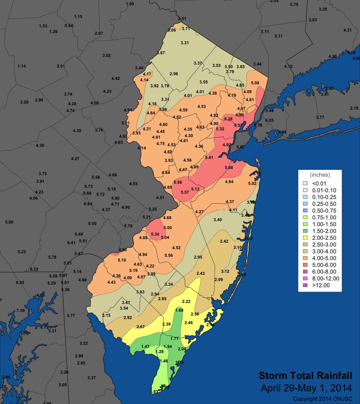
|
|---|
|
County |
Prcp |
Town |
|
Atlantic |
3.25" |
Hammonton |
|
Bergen |
5.14" |
Palisades Park |
|
Burlington |
5.44" |
Medford |
|
Camden |
4.53" |
Merchantville |
|
Cape May |
1.96" |
Sea Isle City |
|
Cumberland |
2.96" |
Bridgeton |
|
Essex |
5.25" |
Maplewood |
|
Gloucester |
6.52" |
Washington Twp |
|
Hudson |
5.20" |
Kearny |
|
Hunterdon |
5.08" |
Lebanon |
|
Mercer |
6.02" |
Robbinsville |
|
Middlesex |
5.59" |
Matawan |
|
Monmouth |
5.20" |
Millstone Twp |
|
Morris |
4.89" |
Chatham |
|
Ocean |
4.25" |
Jackson Township |
|
Passaic |
4.17" |
Little Falls |
|
Salem |
4.11" |
Pennsville |
|
Somerset |
5.02" |
Warren Twp |
|
Sussex |
3.31" |
Sussex |
|
Union |
5.34" |
Kenilworth |
|
Warren |
4.80" |
Washington |
Table 1. The wettest CoCoRaHS stations in each NJ county for the rainfall event from April 29-May 1.
Despite several timely rainfall events over the course of April, fields and forests dried up quickly with abundant sun, mild temperatures, and frequently windy conditions. Also, given that the green up of vegetation was one to two weeks behind schedule, leaf-strewn forest floors remained exposed to the sun and dormant grasses remained dry. This was all a recipe for wildfire, and on three occasions blazes erupted. The first was from the 6th-7th when approximately 1500 acres of Wharton State Forest in Washington Township (Burlington) burned. Southerly winds drifted the dense smoke northward and a nighttime atmospheric inversion (warm air overlying cold air) trapped the smoke close to the ground. Thus the smell of burning wood permeated central and northeastern NJ as well as New York City and ground-level visibilities were compromised. This left many residents looking for a local fire until hearing news reports of the distant flames and in many cases receiving a lesson on atmospheric inversions!
The 10th saw a multi-acre brush fire in Edison (Middlesex), with the plume of smoke visible over central NJ, this time rising high into the sky before dispersing. A number of fires erupted across the state from the 24th-25th. Two burned in Berkeley Township (Ocean), including one of 300 acres that for a time threatened homes and forced the evacuation of a school. Others occurred in Manchester Township (Ocean), Lacey Township (Ocean), Franklin Township (Gloucester), Shamong Township (Burlington), and a rather large one in Downe Township (Cumberland). The rains of the 25th-26th were of welcome assistance to the efforts of fire fighters extinguishing these blazes. No major injuries or deaths occurred and only minor damage was recorded from any of these blazes.
The lowest atmospheric pressures of the month occurred on the 8th at about 29.40". Highest values were between 30.60"-30.65" on the 18th.
April was a rather windy month, with gusts exceeding 40 mph at one or more locations on 11 days. The first of these days was the 5th when Wantage (Sussex) gusted to 42 mph. Woodbine (Cape May) reached 47 mph on the 7th, and High Point Monument (Sussex) 41 mph on the 8th and 9th. Wantage topped out at 43 mph on the 9th. The 14th brought a 45 mph gust to Wantage and 42 mph in Upper Deerfield (Cumberland). Wantage hit 58 mph and High Point Monument 52 mph on the 15th, with 28 of the 49 NJWxNet stations observing wind having gusts of at least 30 mph. The Monument and Wantage reached 48 mph and 41 mph, respectively, on the 16th.
The next episode of strong winds began on the 23rd, the windiest day of April. Wantage gusted to 58 mph, High Point Monument to 52 mph, five stations had gusts in the 40-49 mph range and 23 between 30-39 mph. The Monument reached 47 mph on the 24th and Wantage 40 mph. On the 29th, Sea Girt (Ocean) gusted to 46 mph and Harvey Cedars (Ocean) 40 mph. The 30th saw gusts of 43 mph at High Point Monument, 41 mph in Pittstown (Hunterdon), and 40 mph at Sea Girt.
Temperature
While most residents felt that April was yet another unseasonably cold month in a relentlessly chilly start to 2014, as noted above, temperatures averaged quite close to normal. Perhaps it was continued aggravation from the previous months or that an extended stretch of mild days only occurred once. The delayed start to the green up season, seemingly associated more with a cold March rather than any remarkable April temperatures, also likely played a role in some people's perception.
On nine April afternoons temperatures equaled or exceeded 70° at one or more of the 52 NJWxNet stations. The 3rd saw a high of 73°° in Cream Ridge (Monmouth). This mark was not achieved again until the 11th, when seven stations leaped to 80°, and 33 others were in the 70°s. Atlantic City Marina (Atlantic) at 61° was coolest on the 11th. Warmth continued for four additional days, with Red Lion (Burlington) to 75° and nine stations at 74° on the 12th. The 13th was by far the warmest April day, the Holmdel (Monmouth) got up to 84° and 25 stations were 80°-83°. Coastal Harvey Cedars (Ocean) only got to 59°. The 14th saw Hawthorne (Passaic) at 80° and eight stations at 79°, while Greenwich (Cumberland) topped out at 70° on the 15th. Five stations made it to 72° on the 21st, and Red Lion hit 80° on the 22nd, along with Holmdel and Howell (Monmouth) at 79°. Greenwich reached 72° on the 26th, with 13 locations at 71°.
On 19 April days the thermometer dipped to the freezing mark or lower somewhere in NJ. Eight of these days saw a location under 25°. This began on the 1st when Walpack (Sussex) got down to 22° and Pequest (Warren) 23°. Walpack and High Point Monument (Sussex) were 29° on the 5th, paling in comparison to the 17° low at Walpack on the 6th, when Pequest was 22°. Walpack reached 19° on the 7th. Walpack dropped to a statewide monthly minimum of 15° on the 10th, when Pequest was 23° and 31 other stations were below freezing. Statewide, the 16th was the coldest morning of April when the High Point Monument and High Point NJWxNet stations dipped to 20° and 21°, respectively. Every other NJWxNet station, with the exception of West Cape May (Cape May) at 34°, fell to or below freezing. The 17th saw Walpack at 16° and Pequest 23°. Walpack and Pequest fell to 24° and 25°, respectively, on the 21st, and Walpack to 24° on the 28th.
For those seeking more detailed information on hourly, daily and monthly conditions, please visit the following Office of the NJ State Climatologist's websites:
NJ Weather and Climate Network
NJ Community Collaborative Rain, Hail and Snow Network
NJ Snow Event Reports
Interested in receiving our monthly summaries at the end of each month? Send us your e-mail address here to join the mailing list.
Past Climate Summaries