

Winter refuses to relinquish its grip on the Garden State: March 2014 Summary
New Jersey State Climatologist
Center for Environmental Prediction, School of Environmental and Biological Sciences/NJAES, Rutgers University
April 5, 2014
One of the most disruptive winters in recent memory continued to deliver cold weather throughout New Jersey during March. Three snow events brought over 20" of snow to Cape May County, yet failed to bring more than flurries to northern counties. The statewide average monthly temperature of 35.3° was 5.8° below normal. Thus March ranked as the 11th coldest since statewide records commenced in 1895 (Table 1). Rain and melted snow for the month averaged 4.11". This is 0.12" below normal and ranks as the 55th wettest of the past 120 Marches. Aside from the southern snows, the bulk of the precipitation fell in a soaking storm at month's end.
|
Rank |
Year |
March Temp |
|
1 |
1916 |
31.3° |
|
2 |
1960 |
31.7° |
|
3 |
1896 |
33.6° |
|
4 |
1906 |
33.9° |
|
5 |
1941 |
34.2° |
|
6 |
1940 |
34.3° |
|
7 |
1926 |
34.7° |
|
8 |
1914 |
35.0° |
|
9 |
1900 |
35.1° |
|
9 |
1984 |
35.1° |
|
11 |
2014 |
35.3° |
|
12 |
1915 |
35.6° |
|
13 |
1937 |
35.7° |
|
14 |
1934 |
36.1° |
|
15 |
1895 |
36.2° |
|
15 |
1932 |
36.3° |
|
15 |
1947 |
36.2° |
Table 1. The 17 coldest Marches across New Jersey since 1895.
Temperature
The enduring winter chill resulted in a December through March average statewide temperature of 31.9° (3.5° below the 1981-2010 normal 2.3°, below the 1895-2014 normal) ranking as the 20th coolest on record. Even more impressive is the 30.4° January-March average, which is the 10th coldest start of a year on record and the coldest since 1978, and before that, 1940 (Table 2). The 12 months ending with March is the coolest such interval (52.2°) since February 2003 – January 2004. However 47% of the 12-month intervals since 1895 have averaged cooler.
|
Rank |
Year |
Dec-Mar Temp |
|
1 |
1904 |
29.9° |
|
2 |
1912 |
28.4° |
|
3 |
1895 |
28.9° |
|
4 |
1934 |
29.2° |
|
4 |
1978 |
29.2° |
|
6 |
1940 |
29.3° |
|
7 |
1905 |
29.6° |
|
8 |
1920 |
29.8° |
|
8 |
1918 |
29.8° |
|
10 |
2014 |
30.4° |
|
11 |
1914 |
30.6° |
|
12 |
1970 |
30.7° |
|
13 |
1994 |
30.8° |
|
13 |
1941 |
30.8° |
|
15 |
1923 |
30.9° |
Table 2. The 15 coldest December-March intervals across New Jersey since 1895-1896.
Despite the cold, there were some mild afternoons scattered throughout the month. However the warmth was always quite fleeting. On nine days the temperature toped 60° at one or more locations. The first occasion was the 8th when Egg Harbor (Atlantic County), Woodbine (Cape May), and Mansfield (Burlington) reached 61°. Woodbine reached 70° on the 11th and Egg Harbor 69°. Statewide, this was the mildest day of the month, as 48 stations of the 54 in the NJWxNet got into the 60°s. The 71° maximum at Red Lion (Burlington) and Holmdel (Monmouth) on the 12th was the warmest of the month. Woodbine, Dennis Twp. (Cape May), and Greenwich (Cumberland) reached 65° on the 15th. Egg Harbor made it to 60° on the 20th. The 22nd saw Mansfield, Egg Harbor, and West Creek (Ocean) reach 68°, with a total of 49 stations in the 60°s. Toward the end of the month, Cherry Hill (Camden) and Greenwich topped out at 66° on the 28th, Oceanport (Monmouth) and Mullica (Atlantic) at 60° on the 29th, and Greenwich and South Harrison (Gloucester) 60° on the 31st.
Eleven March days had minimum temperatures in the single digits above or below zero at one of more NJ locations. As usual, Walpack (Sussex), tucked away in a northwest valley, was one the coldest locations on nine of these days. This began on the 1st when Walpack fell to -8°. Pequest (Warren) was next coldest that day at -1°, while 27 stations were in the positive single digits, with Atlantic City Marina (Atlantic) the "mildest" at 23°. Walpack and Berkeley Township (Ocean) were -3° on the 3rd. With fresh snow on the ground in the south on the evening of the 3rd the temperature fell to 2° at the Atlantic City Airport station in Pomona (Atlantic). This was the coldest March temperature at this location based on records going back to 1958. The temperature rose several degrees before midnight and stayed above that mark through dawn. Elsewhere, the 4th dawned as the coldest morning of the month. Walpack plummeted to -9° and High Point Monument (Sussex) -1°, while 34 stations were between 0° and 9° and three coastal stations the least cold at 14°. The 5th saw Berkeley Township at 7° and Red Lion (Burlington) 8°. This cold spell continued on the 6th, with Walpack at 1° and three locations 4°, and into the 7th with Walpack at 5°.
High Point Monument fell to 7° on the 14th, with nearby High Point at 8°. Late in the month, unusual cold brought Walpack to 9° on the 24th, 7° on the 25th, and 9° on the 27th.
Precipitation and storms
With the 4.11" of average statewide precipitation in March, the average for the first three months of 2014 is 12.52". This is 1.95" above normal and ranks as the 24th wettest start to the year since 1895. Until the last several days of March, the month seemed destined to be one of close to average moisture in the south and one of the driest on record in the north. For instance, New Brunswick (Middlesex) would have ended the month as the 6th driest since 1893. That is until the statewide deluge arrived on the 29th, resulting in the location's 31st wettest March.
When all was said and done, the southeast came in as much as 2" above average and the northwest about 1.5" below average. Hammonton (Atlantic) took top honors with 6.94", followed by Woodbine (Cape May) with 6.18" and 5.88" at two locations, two Estell Manor (Atlantic) stations with 6.00" and 5.79", and Egg Harbor Township (Atlantic) at 5.85". On the low end, Montague (Sussex) received 2.62" during March, followed by Wantage (Sussex) at 2.76", Bernards (Somerset) 2.79", Hackettstown (Warren) 2.80", and Lebanon (Hunterdon) 2.86".
A rather remarkable and persistent storm track and the colder-than-average temperatures resulted in the southern half of the state being blanketed with moderate to heavy snow on three occasions. Meanwhile, the northern half was essentially shut out of anything but a few flurries. Wildwood Crest (Cape May) received 21.8" for the month, which amounts to more than the annual average in this part of the state. Sea Isle City (Cape May) caught 20.8", Woodbine 20.6", Estell Manor 17.1", and Egg Harbor Township 16.6". In addition to hefty totals in Cape May and Atlantic counties, over 10" fell over much of Cumberland, Salem, Gloucester, Ocean, and Burlington counties. Less than a half inch accumulated north of a line through central Mercer, southern Middlesex, and northern Monmouth counties.
For the state as a whole, the 5.9" average snowfall was 1.7" above normal and ranked as the 28th snowiest March since 1895. Southern counties (Burlington, Ocean and all counties south of there) averaged 11.9", which is 9.0" above normal and ranks 7th snowiest. Northern counties (Warren-Morris-Essex and north) averaged 0.1", which is 6.0" below normal. Only five Marches have failed to have measurable snow in the north, with this year joining five others at 0.1". Central counties averaged 0.4", or 4.5" below normal, which ranks 23rd lowest.
Temperatures in the upper teens and low 20s accompanied the first southern snowstorm of March on the 3rd. The southeast received 5.0"-7.0", as did a portion of Gloucester County. Less than an inch fell north of the previously mentioned March snow line from central Mercer through Middlesex and northern Monmouth counties. Ventnor (Atlantic) topped out at 7.0", followed by 6.5" in Belleplain (Cape May), 6.1" at Manahawkin (Ocean), and 6.0" totals at eight locations (Figure 1). Some rain preceded the snow in the south, and together the rain and melted snow amounted to 1.24" and 1.01" in Sea Isle City, 1.20" at Wildwood Crest, and 0.98" and 0.88" in Woodbine, all in Cape May County.
Figure 1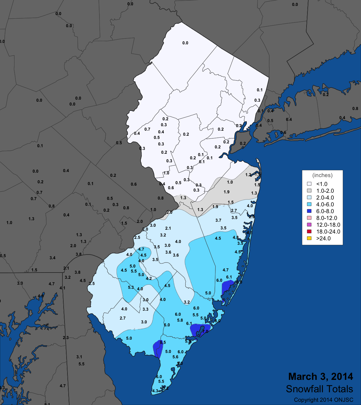
|
|---|
After a mild day on the 12th an evening squall line barreled through NJ, resulting in local downpours and plummeting temperatures. Heaviest rains were in the southwest, with 0.70" at Pittsgrove (Salem), 0.66" in Upper Deerfield (Cumberland), and 0.65" in Clayton (Gloucester). The bulk of the state received 0.10"-0.30".
From late on the 16th into the 17th another significant snow event whitened the south but left the north unscathed. The cut off line for snowfall was remarkably similar to the storm on the 3rd, only this time southern totals were a bit heavier. Totals increased steadily toward the south, topping out at over 8" in extreme southern Atlantic County and all of Cape May County. Totals from Cape May included 11.1" at Wildwood Crest, 10.0" in Dennisville, and 9.8" in Woodbine. Maximum totals in other southern counties included 8.5" at Linwood (Atlantic), Newport (Cumberland) 6.8", Pittsgrove (Salem) 7.0", Clayton (Gloucester) 6.0", Somerdale (Camden) 5.1", Berkeley Township (Ocean) 6.5", and Medford and New Gretna (Burlington) both with 6.0" (Figure 2).
Figure 2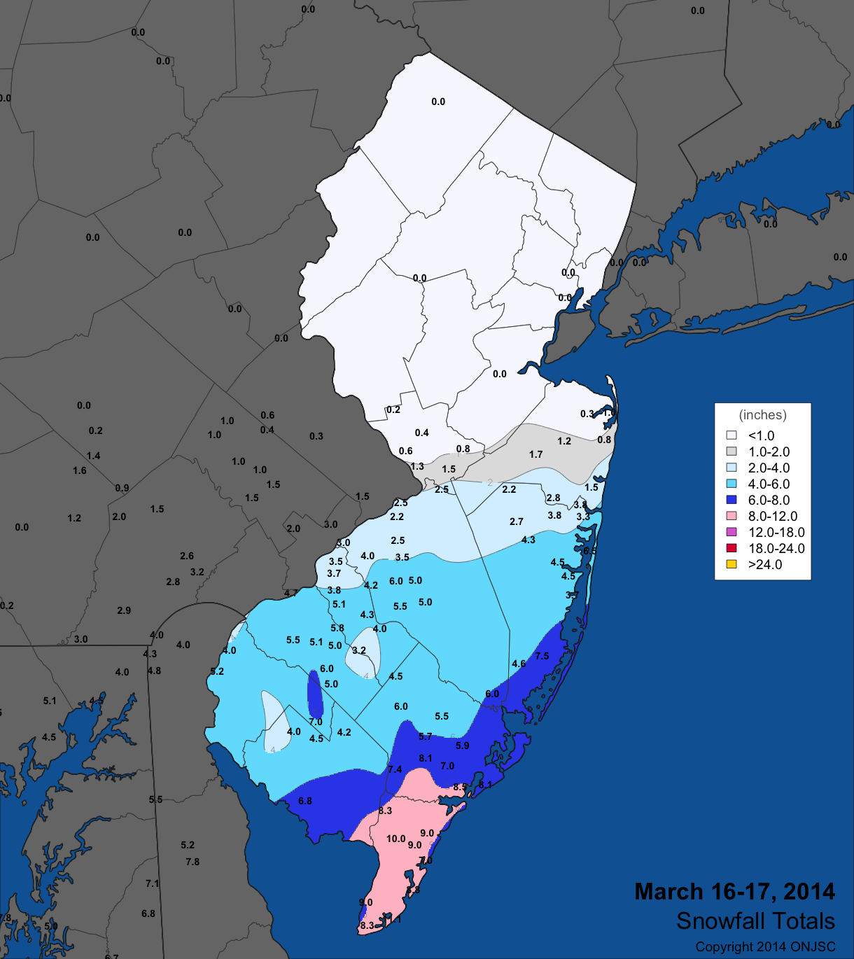
|
|---|
Rain covered the state from the late afternoon of the 19th into the pre-dawn hours of the 20th. The northern half received 0.50"-1.00", with a bit more in the northeast, while 0.30"-0.50" fell in the south. Top totals included 1.31" in Cedar Grove (Essex), Denville (Morris) 1.27", Rockaway (Morris) 1.25", and Palisades Park (Bergen) 1.23".
Yet another snowstorm struck southern Jersey from the late afternoon of the 25th into the 26th. Cape May County again ruled supreme, with 6.5" in Cape May and North Cape May and 6.2" at Sea Isle City. Totals slackened to the north and northwest, with less than an inch accumulating northwest of the NJ Turnpike in southern areas, with a dusting to not even a flake north of Mercer, southern Middlesex, and Monmouth counties (Figure 3). Melted snow amounted to 0.76" of liquid in Woodbine, 0.69" at Wildwood Crest, and 0.61" in Sea Isle City.
Figure 3
|
|---|
Scattered rain showers on the 28th generally brought under 0.10" across NJ, except close to 0.25" in Cape May County. This was a light prelude to, thus far, the wettest storm of 2014 that soaked the state from the 29th through the morning of the 31st. The bulk of the heavy rain fell from the afternoon of the 29th into the early hours of the 30th. However occasional heavy showers persisted on the 30th, with the event ending as a mix of rain, sleet and snow on the 31st. There was little to no snow accumulation. When all was said and done, 3.00-3.50" fell across much of central portions, followed by about 3" in the central south (Figure 4). Generally 1.50"-2.00" fell in the northwest and southern Cape May County, with amounts between 2.00"-3.00" over the remainder of NJ. Over the two-day period of the 29th-30th, the "Brunswicks" in Middlesex County captured top honors, with North Brunswick at 3.75", East Brunswick with 3.73", New Brunswick 3.33", and South Brunswick 3.27". Woodbridge (Middlesex) caught 3.51" and River Vale (Bergen) 3.47". Three Franklin Township (Somerset) gauges caught 3.37", 3.36", and 3.35", while Franklin Township (Gloucester) received 3.35". Minor flooding occurred on roadways and streams and on some rivers, including the Millstone River in Somerset County.
Figure 4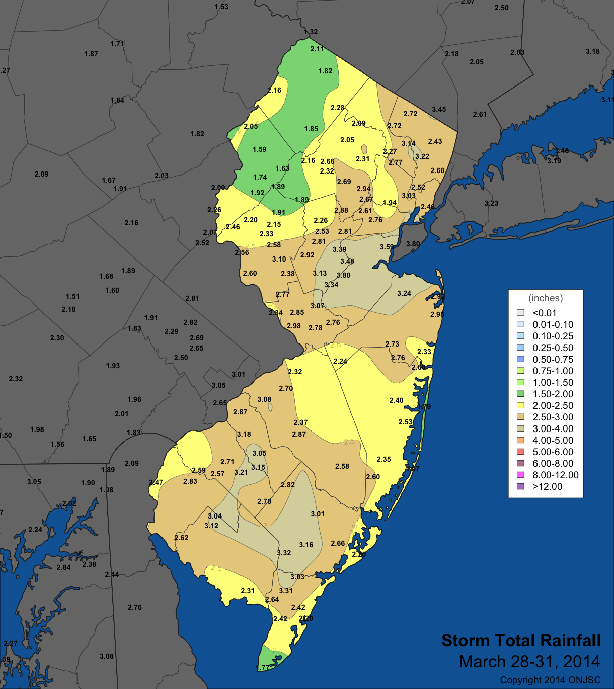
|
|---|
The highest barometric pressure of the month was between 30.60" and 30.70" on the 6th. The lowest pressure was between 29.15" and 29.25" on the 13th. Winds gusted to 40 mph or higher on ten March days, from the 12th onward. On the 12th Wantage (Sussex) and High Point Monument (Sussex) peaked at 64 mph and 62 mph, respectively, with nine NJWxNet locations gusting into the 40-49 mph range. The 13th was even windier, with gusts of 62 mph at the Monument, 59 mph at Wantage, 56 mph in Harvey Cedars (Ocean), 51 mph at Seaside Heights (Ocean), and 40-49 mph gusts at sixteen stations, with twenty others in the 30-39 mph range. The 15th saw Harvey Cedars at 47 mph, High Point Monument at 44 mph, and 42 mph at Atlantic City Marina (Atlantic). Cream Ridge hit 43 mph on the 19th, Charlotteburg (Passaic) 42 mph on the 20th, and Wantage 41 mph on the 22nd. The Monument topped out at 54 mph on the 26th, with Wantage at 51 mph. The 27th saw 44 mph at Wantage and 43 mph at the Monument, and the 28th 44 mph in Cream Ridge (Monmouth). Wantage peaked at 41 mph on the 31st.
The strong winds on the 26th, generated from an extremely strong nor'easter off the New England coast, in concert with a quite dry March up to that point fanned the flames of a brush fire in the Meadowlands of Hudson and Essex counties. Service on the major Northeast Corridor train line was suspended for a short time.
For those seeking more detailed information on hourly, daily and monthly conditions, please visit the following Office of the NJ State Climatologist's websites:
NJ Weather and Climate Network
NJ Community Collaborative Rain, Hail and Snow Network
NJ Snow Event Reports
Interested in receiving our monthly summaries at the end of each month? Send us your e-mail address here to join the mailing list.
Past Climate Summaries