Spring Foolery: March 2022 Recap
New Jersey State Climatologist
Center for Environmental Prediction, School of Environmental and Biological Sciences/NJAES
Rutgers University
April 6, 2022
Overview
When it comes to shedding the winter coat and thinking of warm weather to come, March is known to have its early spring teases. Then, along comes some late winter cold to remind us winter is not quite ready to disappear. This spring foolery was on exceptional display this month. High temperatures jumped into the 70°s on the 6th and 7th, then back to the cold until the 70° mark was again eclipsed during four of the five days from the 15th–19th. Next came some more seasonable temperatures before a polar blast brought mid-winter frigid conditions from the 28th–30th, only to be followed by another day of 70°s to end the month. Interspersed with these wild fluctuations were episodes of thunderstorms, snow and rain, and 13 days where winds gusted to greater than 40 mph at some locations.
When all was said and done, the statewide average temperature of 43.6° was 2.6° above the 1991–2020 normal. This ranked as the 16th mildest March since 1895, with the end-of-month cold spell keeping the month out of the top 10 for warmth. The average maximum of 54.0° was 3.1° above normal, ranking 17th mildest. The average minimum of 33.3° was 2.1° above normal, also ranking 17th. The north averaged 41.1° (+2.3°, 21st warmest), south 45.3° (+2.9°, 15th), and coast 44.9° (+2.7°, 13th).
Precipitation averaged 2.72” across NJ, which was 1.48” below normal and ranks as the 26th driest March since 1895. The north caught 2.54” (-1.47”, 26th driest), south 2.80” (-1.52”, 30th), and coast 3.06” (-1.36”, 34th). In particular, a zone from Hunterdon to Bergen counties was driest and the coast from Atlantic to Monmouth counties was wettest (Figure 1).
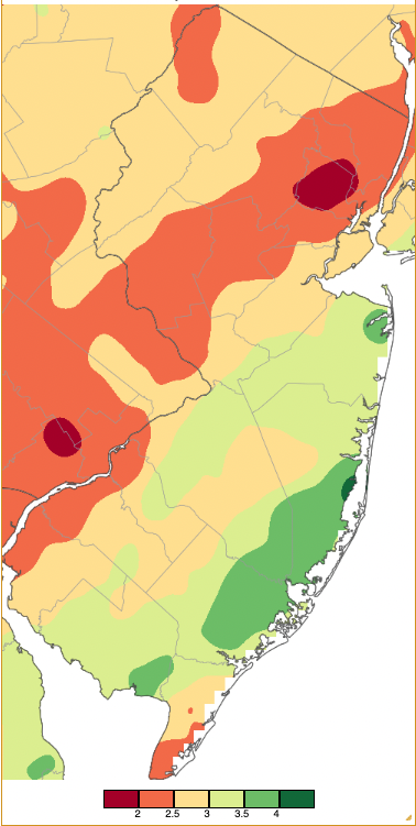
Figure 1. March 2022 precipitation across New Jersey based on a PRISM (Oregon State University) analysis generated using NWS Cooperative and CoCoRaHS observations from 7AM on February 28th to 7AM on March 31st (PM rainfall on the 31st to be included in April totals). Note the scale in full inches at the bottom of the map. Totals range from 1.50”–2.00” (dark red) to 4.00”–4.50” (dark green).
Snowfall averaged 1.8” across NJ. This is 2.7” below normal and ranks as the 49th least snowy March back to 1895. The northern counties averaged 5.0” (-2.1”, 68th least snowy), central counties averaged 1.8” (-3.5”, 46th least snowy), and southern counties averaged 0.0” (-2.7”, tied 36 years for least snowy). Through March, the snow season has deposited an average of 22.4” across the state, 2.8” below the 1991–2020 normal. Northern counties have come in with 22.7” (-11.9”), central ones 16.6” (-11.7”), and southern ones 24.8” (+6.2”). Should the south hold on to the highest of the three regional totals, it will mark just the third season back to 1894/95 where this has occurred. The others were in 1978/79 and 2009/10. Can the north perhaps sneak past the south with a late season storm? Such suspense! More on the snow season in the May report.
Temperature
As mentioned previously, there were seven March days where the maximum temperature at a NJWxNet station reached or exceeded the 70° mark. Ten other days saw highs in the 60°s. Of the warmest ones, the 6th found Cape May Court House (Cape May County) up to 73°, with 24 NJWxNet station from 70°–72°. Record highs were set at the Newark Airport NWS weather station in Elizabeth (Union; 69°) and Atlantic City Airport NWS station in Pomona (Atlantic; 71°). As occurs on many warm spring days, there was pronounced cooling along the Atlantic and/or Delaware Bay coasts (Raritan Bay and the NY/NJ harbor area too). Temperatures can quickly fluctuate by 10°–20° near the coast as the wind direction subtly changes from off the still cold offshore waters to a more landward source. Such was the case at Sea Girt (Monmouth) on the 6th and 7th (Figure 2). Given the exceptional inland warmth, even during the overnight period, a temperature timeseries shows multiple rapid swings from the low 50°s to upper 60°s, also seen to a lesser extent in dew point temperatures. The most notable fluctuation included warming surrounding midnight from the 6th into the 7th. This can be compared with the relatively smooth progression of temperatures at Howell (Monmouth), 10 miles inland from Sea Girt. At Howell, steady upper 60°s during the day and well into the night of the 6th tailed off to a low close to 55° around sunrise on the 7th before quickly rising into the upper 70°s by noon, when Sea Girt was stuck in the mid 50°s. Note the cool coastal temperatures, just 50° at Harvey Cedars (Ocean), during the late morning on the 7th, with mid 70°s inland (Figure 3). Clouds in Sussex County portended incoming rain and cooler temperatures that were to move southward thought the state during the afternoon and evening of the 7th, ending the early March warm spell.
Before the colder air arrived, Berkeley Township (Ocean), Holmdel (Monmouth), Oceanport (Monmouth), and Sicklerville (Camden) topped out at 78°. 32 stations reached 75°–77°, and 15 from 70°–74° (Figure 4). Record highs were achieved at New Brunswick (Middlesex) 75°, Newark Airport 76° (also a record high minimum of 50°), Atlantic City Airport 76°, and Trenton Airport in Ewing Township (Mercer) 74°.
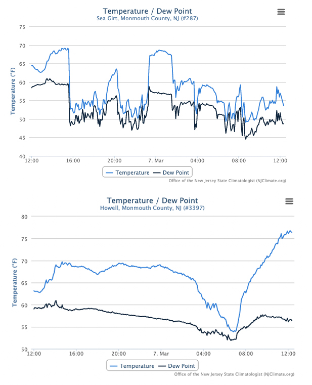
Figure 2. Time series of temperature and dew point temperature at Sea Girt (top) and Howell (bottom) from noon on March 6th to noon on the 7th.
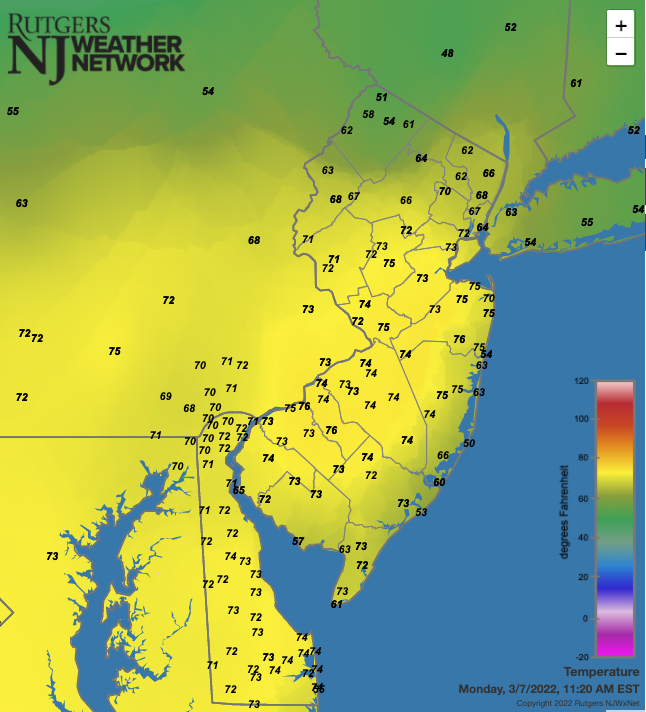
Figure 3. Temperatures across NJ and nearby states at 11:20 AM on March 7th. Observations are from NJWxNet, National Weather Service, and Delaware Environmental Observing System stations.
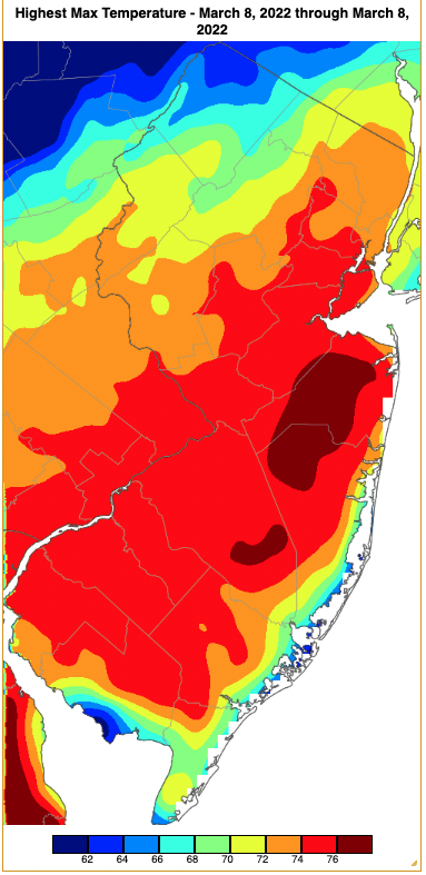
Figure 4. Maximum temperatures on March 7th based on a PRISM (Oregon State University) analysis generated using NWS, NJWxNet, and other professional weather stations. Note the 2 degree increment scale beneath the map.
Following a week of colder weather, the 70°s returned on the 15th with a maximum of 72° at Sicklerville, and 19 stations from 70°–72°. Harvey Cedars only made it to 52°. Sicklerville was 74° on the 16th, followed by Red Lion (Burlington) and West Deptford (Gloucester) at 73°, and 21 stations from 70°–72°. Red Lion and Sicklerville reached 77° on the 18th, with 15 stations from 75°–76° and 31 from 70°–74°. West Cape May (Cape May) was coolest at 56°. A classic sea breeze was seen during the mid-afternoon along every NJ coastal area resulting in temperatures commonly 10°–20° cooler than nearby inland locations.
The monthly maximum of 79° was achieved at Sicklerville on the 19th, followed by 78° in Howell, 75°–77° at 27 locations, and 70°–74° at 23 other stations. A record high of 73° was tied at Atlantic City Airport. Record high minimums for the 19th included 52° at Atlantic City Airport and 51° at Atlantic City Marina (Atlantic). Finally, the end-of-month cold spell abruptly ceased, with Hillsborough-Duke (Somerset) reaching 73° on the 31st, along with 23 stations from 70°–72°.
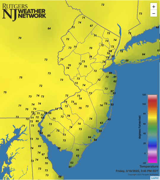
Figure 5. Temperatures across NJ and nearby states at 3:45 PM on March 18th. Observations are from NJWxNet, National Weather Service, and Delaware Environmental Observing System stations.
Despite the overall March mildness, minimum temperatures fell between 10°–19° at one or more NJWxNet station on 12 days. There were seven days where every station fell below freezing (3rd, 4th, 12th, 13th, 28th, 29th, and 30th). On the flip side, there were seven other days where the temperature failed to fall to the freezing point at any station (6th, 7th, 17th–20th, and 25th). The 1st found Berkeley Township and High Point Monument (HPM; Sussex) down to 18°. HPM fell to 13° on the 3rd, with seven stations from 15°–20°. Hopewell Township (Mercer) and HPM reached the state monthly minimum of 10° on the 4th, with 16 stations from 11°–15°, and Atlantic City Marina “mildest” at 24° (Figure 6). The map shows the inverse of the earlier presented thermal sea breeze pattern with coastal (and urban) areas milder than inland locations. Cold in the Pinelands approached that of all other cold areas except the northwest. It remained cold on the 5th, with lows of 14° at Walpack (Sussex) and 15° at Pequest (Warren) and Sandyston (Sussex).
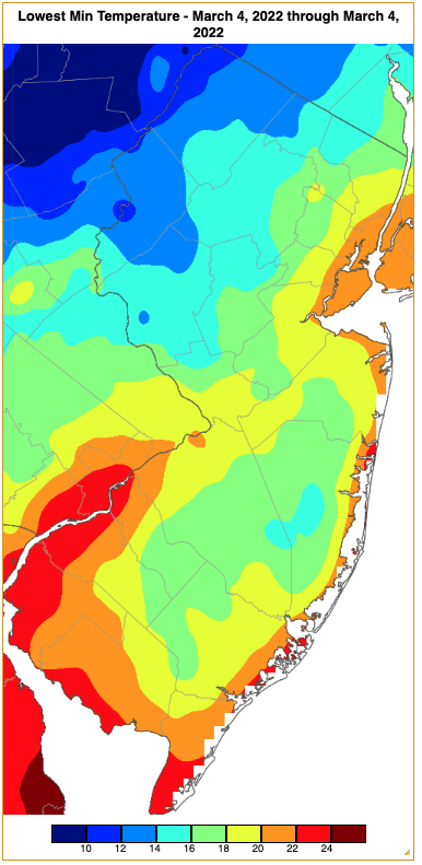
Figure 6. Minimum temperatures on March 4th based on a PRISM (Oregon State University) analysis generated using NWS, NJWxNet, and other professional weather stations. Note the in 2 degree increment scale beneath the map.
Sandyston dropped to 19° on the 10th. HPM reached 12°, High Point (Sussex) 14°, and Vernon Township (Sussex) 15° on the 12th, indicative of cold air advecting into the state at higher elevations. On the 13th, HPM fell to 11°, High Point and Vernon Township each 13°, and Sandyston and Wantage (Sussex) each 15°. The valleys were coldest on the 14th with Pequest and Sandyston each 18°.
The cold wave at month’s end began with a low of 18° at HPM late on the 27th. The morning of the 28th saw HPM down to 12°, High Point and Vernon Township each 14°, and 11 stations from 16°–20°. Maximum temperatures on the 28th failed to make it out of the 30°s across NJ and stayed below the freezing mark in many locations. Record low maximums for the day were achieved at Newark Airport 35°, Trenton Airport 32°, Atlantic City Airport 38°, and Atlantic City Marina 35°. HPM dropped to 14° on the 29th, with 11 stations again from 16°–20°. The final night of cold on the 30th brought calmer winds, clear skies, and resultant cold air drainage into the valleys. Walpack and Berkeley Township hit 14°, Sandyston 15°, and 17 locations from 16°–20°. Atlantic City Airport had a record low of 20°.
Precipitation and Storms
As mentioned earlier, March, in general, was low on snowfall and precipitation. Only the wettest locations had close to normal totals. This includes CoCoRaHS stations in Lacey Township (Ocean) with 4.32”, Berkeley Township 4.22”, two Galloway Township (Atlantic) sites with 4.09” and 3.99”, Pine Beach (Ocean) 4.07”, Weymouth Township (Atlantic) 4.06”, and Hamilton Township (Atlantic) 4.01”. The driest locations included Maplewood (Essex) with 1.67”, Bernards (Somerset) where two stations saw 1.69” and 1.78”, South River (Middlesex) 1.73”, Harding Township (Morris) 1.76”, Verona (Essex) 1.92”, and 1.97” in both North Arlington (Bergen) and Clinton (Hunterdon).
Monthly snowfall accumulated to 10.8” in Montague (Sussex), Vernon Township 8.4”, Mt. Olive (Morris) 8.2”, Hardyston (Sussex) and Sparta (Sussex) each with 8.0”, and Wantage 7.8”.
The first event of note was a thunderstorm-ladened squall line that traveled southward through the state during the afternoon and evening of the 7th, breaking the warmth of the previous two days. Bethlehem Township (Hunterdon) saw 0.40”, Greenwich Township (Warren) 0.37”, and Washington Township (Warren) 0.31”. Strong winds accompanied and followed the rain, gusting to 63 mph at HPM, 60 mph at Newark Airport and Fort Dix (Burlington), Hillsborough-Duke and Lyndhurst (Bergen) 54 mph, Logan Township (Gloucester), Pittstown (Hunterdon), and Lower Alloways Creek Township (Salem) 52 mph, Moorestown (Burlington) 50 mph, and 23 NJWxNet stations 40–49 mph. Trees brought down wires, leading to power outages, and fell on vehicles and structures. A suspected downburst in the Peapack-Gladstone (Somerset) and Bernards area may have had winds up to 80–90 mph, bringing down trees. Winds on the 8th gusted to 56 mph at HPM, 48 mph at Little Egg Harbor Township, and 40–45 mph at nine NJWxNet stations.
A moderate storm from the pre-dawn hours to evening of the 9th brought rain to the south, a snow-rain mix to central and northeast areas, and mainly snow to the northwest. Rain and melted snow amounted to as much as 0.86” in Middle Township (Cape May), Roxbury (Morris) 0.86”, Weymouth Township (Atlantic) 0.80”, and Boonton (Morris) 0.76”. Snowfall exceeded 1.0” in all or portions of seven counties. This included Sussex County totals of 5.5” in Montague and 5.0” at Wantage, Bloomingdale (Passaic) 3.7”, Green Pond (Morris) and Kinnelon (Morris) each with 3.3”, Blairstown (Warren) and Oakland (Bergen) 2.5”, and Lebanon (Hunterdon) and Caldwell (Essex) 2.0” (Figure 7).
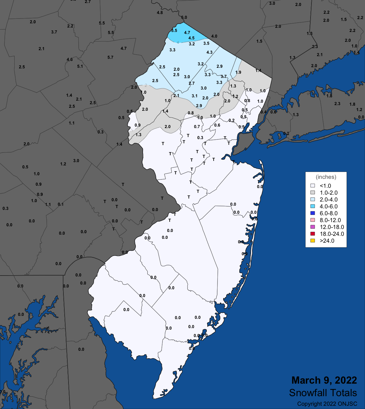
Figure 7. Snowfall on March 9th. Observations are from CoCoRaHS, NWS Cooperative Observer, and NWS Trained Spotter reports.
The first of two March storms that brought more than an inch of rain or melted snow to NJ began early on the 12th, departing the state during the afternoon. Beginning as rain everywhere, as cold air poured into the state during the morning, rain quickly turned to snow except near the coast where heavy rain fell at times before some light snow mixed in late in the event. Precipitation totaled as much as 1.37” in Absecon (Atlantic), Hamilton (Atlantic) 1.14”, and 1.07 in both Lacey Township and Pine Beach (Ocean). At least an inch fell in 14 locations, with 118 of the 223 CoCoRaHS reports coming in from 0.50”–0.99” (Figure 8).
Snow on the 12th accumulated to 1.0” or more in 13 counties, with five catching 3.0” or more. These included Mt. Olive 6.0”, High Point, Highland Lakes (Sussex), and Montague 5.3”, Mansfield Township (Warren) 4.5”, Holland Township (Hunterdon) 4.0”, and West Milford (Passaic) 3.3” (Figure 9). This storm generated extreme winds that included a station record 82 mph gust at HPM between 2:45–2:50 PM. HPM had gusts of 60–75 mph during 18 five-minute intervals. Elsewhere, Fortescue (Cumberland) and Little Egg Harbor Township (Ocean) gusted to 55 mph, Wantage and West Cape May both hit 53 mph, Harvey Cedars 52 mph, and 20 stations from 40–49 mph. Winds the following day reached 63 mph at HPM, Atlantic City Marina 57 mph, Fortescue 54 mph, Little Egg Harbor Township 53 mph, Wantage 51 mph, and nine locations from 40–47 mph.
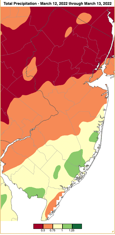
Figure 8. Precipitation across New Jersey from 7AM on March 11th through 7AM March 13th based on a PRISM (Oregon State University) analysis generated using generated using NWS Cooperative and CoCoRaHS observations. Note the scale in inches beneath the map.
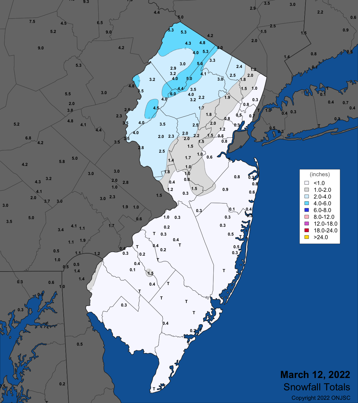
Figure 9. Snowfall on March 12th. Observations are from CoCoRaHS, NWS Cooperative Observer, and NWS Trained Spotter reports.
A modest 0.52” of rain at Galloway and Pine Beach and 0.49” at Hamilton (Atlantic) fell from the morning to early afternoon of the 17th. Next, on the evening of the 19th, scattered thunderstorms in northern and central areas brought Jefferson Township (Morris) 0.58”, Knowlton Township 0.57”, and West Milford 0.48”. Winds gusted to 44 mph at Cream Ridge (Monmouth) and Pennsauken (Camden), and 43 mph at HPM.
The wettest event of the month was an extended one that began with scattered light rain during the late afternoon and evening of the 23rd, then heavier rain fell during early hours of the 24th. A daytime break in the action occurred before rain resumed during the evening, ending in the pre-dawn hours of the 25th. Totals were as high as 2.52” in Berkeley Township, Lacey Township 2.32”, Long Branch (Monmouth) 2.19” and 2.14”, Stafford Township (Ocean) 2.15” and 2.06”, and Neptune (Monmouth) 2.08”. Of 246 CoCoRaHS reports, 12 were from 2.00”–2.32”, 84 from 1.00”–1.99”, and 144 from 0.50” –0.99” (Figure 10). Rain early on the 25th fell at temperatures below freezing above about 1400’ in elevation in the northwest. Ice accumulated to several tenths of an inch at High Point State Park (Sussex; Figures 11 and 12).
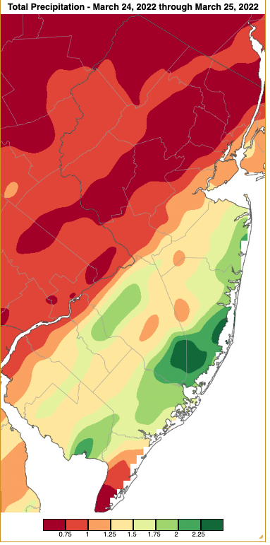
Figure 10. Precipitation across New Jersey from 7AM on March 23rd through 7AM March 25th based on a PRISM (Oregon State University) analysis generated using generated using NWS Cooperative and CoCoRaHS observations. Note the scale in inches beneath the map.

Figure 11. Freezing rain accumulation at High Point State Park on March 24th. Photo courtesy of Shawn Viggiano.

Figure 12. Freezing rain accumulation at High Point State Park on March 24th. Photo courtesy of Shawn Viggiano.
As cold air moved in and through NJ from the 26th to 28th, significant atmospheric instability resulted in scattered squalls of rain, pea-size hail (26th), graupel, and snow, at times briefly lowering visibility but with little or no accumulation. Also accompanying were several days of strong, persistent winds that began on the 26th with gusts to 47 mph at Lower Alloways Creek Township, 44 mph in Little Egg Harbor Township, 43 mph at Fortescue, and 40 mph in Pennsauken. The 27th found gusts to 53 mph at Lower Alloways Creek Township, 46 mph at HPM, and 40–45 mph at seven locations. HPM reached 52 mph on the 28th, Harvey Cedars 49 mph, Sea Girt 46 mph, and eight locations 40–45 mph. HPM reached 51 mph on the 29th.
A squall line during the evening of the 31st brought rain exceeding an inch in the northwest, tapering to less than 0.10” in the south. As this occurred after CoCoRaHS and NWS Cooperative station morning observing times, it will go into the records as occurring on April 1, thus is not included in March totals. This event will be discussed more fully in the April report. Winds on the 31st gusted to 53 mph at Little Egg Harbor Township, 51 mph at Atlantic City Marina, and 40–47 mph at 15 NJWxNet stations.
The highest barometric pressures of the month occurred on the 4th, ranging from approximately 30.55”–30.60”. Lowest pressures were on the stormy, windy 12th, coming in at 29.20”–29.35”. Aside from the previously-mentioned ten days with gusts of 40 mph or greater, such gusts were also achieved at HPM on the 3rd at 46 mph. Also, on the 20th, HPM reached 45 mph, Harvey Cedars 42 mph, and Columbus (Burlington) 40 mph, with HPM attaining 44 mph on the 21st.
For those seeking more detailed information on 5-minute, hourly, daily, and monthly conditions, please visit the following Office of the NJ State Climatologist's websites:
Rutgers NJ Weather Network
NJ Community Collaborative Rain, Hail and Snow Network
NJ Snow Event Reports
Interested in receiving our monthly summaries at the end of each month? Send us your e-mail address here to join the mailing list.
Past News Stories

