Flipping the Seasonal Switch: September 2022 Recap
New Jersey State Climatologist
Center for Environmental Prediction, School of Environmental and Biological Sciences/NJAES
Rutgers University
October 6, 2022
Overview
Following a hot and dry summer, the questions of the day in September were when the temperature would begin to cool and would more abundant rainfall arrive. Signs of a rainfall resurgence were mixed, with drought conditions diminishing in spots but worsening in others. The temperature answer came in almost a flash on the 22nd (the first day of astronomical fall!) when a powerful cold front sent the thermometer quickly downward with an early-fall-like pattern arriving and remaining through month’s end.
September temperatures averaged 67.8° across NJ. This is 0.9° above the 1991–2020 normal and ties as the 22nd mildest September since statewide records commenced in 1895. The average high temperature was 78.2°, which is 1.0° above normal and tied for 23rd warmest. The average low was 57.3°, 0.7° above normal and ranking 23rd warmest. North Jersey came in at 65.7° (+0.8°, tied for 23rd warmest), the south 69.0° (+0.9°, tied for 21st warmest), and the coast 69.7° (+1.0°, 15th warmest).
NJ precipitation averaged 3.16” for September, which is 1.00” below normal and ranks as the 57th driest of the last 128 years. The north was wettest at 3.64” (Figure 1). This is 0.82” below normal, though ranks as just the 67th driest. The south came in with 2.86” (-1.13”, 51st driest) and the coast 2.98” (-0.91”, 57th driest).
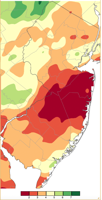
Figure 1. September 2022 precipitation across New Jersey based on a PRISM (Oregon State University) analysis generated using NWS Cooperative and CoCoRaHS observations from 8 AM on August 31st to 8 AM on September 30th. Note the scale in full inches at the bottom of the map. Totals range from 1.00–2.00” (dark red) to 7.00”–8.00” (dark green).
Precipitation and Storms
The heaviest rains fell along the southeast coast, a zone from Hunterdon County east to Union County, and in the far northwest. Top totals were 6.30” at Ocean City (Cape May County), Woodbine (Cape May) 6.28”, Egg Harbor Township (Atlantic) 6.23”, Clinton (Hunterdon) 5.97”, Montague (Sussex) 5.88”, and Califon (Hunterdon (5.81”). On the low end were the Burlington County communities of Columbus with 1.39” and Evesham Township’s 1.71”. Hamilton (Mercer) received 1.66”, and low totals in Monmouth County included Eatontown 1.46”, Holmdel 1.57”, Cream Ridge 1.63”, Little Silver 1.64”, Middletown 1.71”, and Colts Neck 1.73”.
The first of four events where at least several stations in NJ reached the inch mark came during the afternoon and evening of the 4th. Showers in northern and central areas brought 1.27” to both Woodbridge (Middlesex) and Chester (Morris), with 1.25” at Franklin (Sussex). The largest event of the month came in multiple parts beginning with rain in the northern half of the state late on the 5th into the 6th. This was followed by heavy rain in the south on the 6th into early on the 7th before tapering off to scattered showers across the state later on the 7th (Figure 2). Hefty storm totals included 5.57” at Ocean City (the bulk of their statewide monthly maximum total of 6.30”), Egg Harbor Township 5.53”, and three Woodbine stations with 4.09” to 4.65”. Of the 289 reporting CoCoRaHS stations, 18 caught from 3.00–3.99”, 35 from 2.00”–2.99”, and 146 from 1.00”–1.99”. Localized roadway flooding was reported but nothing worse than this, in part due to sandy southern soils and the overall antecedent dry conditions across NJ.
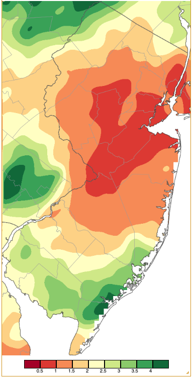
Figure 2. Precipitation across New Jersey from 8 AM on September 5th through 8 AM September 8th based on a PRISM (Oregon State University) analysis generated using generated using NWS Cooperative and CoCoRaHS observations. Note the scale in inches beneath the map.
Rain fell again during the 11th into early on the 12th. West central areas received the most, including 1.01” at both Bethlehem (Hunterdon) and Lebanon (Hunterdon), and 0.92” in Washington Township (Morris). More substantial rain fell in this area and further east late on the 12th into the early 13th. Califon picked up 2.65”, Hopewell Township (Mercer) 2.62”, Lebanon 2.62”, and Clark (Union) 2.59” (Figure 3). Some 17 observing sites received 2.00”–2.65” and 63 from 1.00”–1.99”.
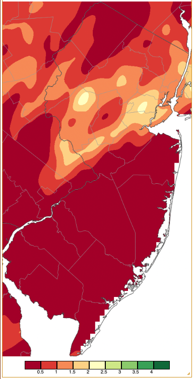
Figure 3. Precipitation across New Jersey from 8 AM on September 12th through 8 AM September 13th based on a PRISM (Oregon State University) analysis generated using generated using NWS Cooperative and CoCoRaHS observations. Note the scale in inches beneath the map.
A rain-free week with clear to partly cloudy skies followed. However, smoke from western US fires resulted in a milkiness to the blue skies, especially from the 16th to 18th. The smoke was over 20,000 feet above the surface, thus could not be smelled, nor was it a health hazard. Shifting winds and some light rain helped clear the skies on the 19th when a late-afternoon line of storms blew through north Jersey. The result was some tree damage in Passaic County and rain totals up to 0.42” in Sparta (Sussex) and 0.39” at Andover (Sussex).
Early-morning showers fell on the 22nd, followed by a strong windy, rain-filled squall line along a cold front that dropped from the northwest through the state from mid-morning to early afternoon. More will be reported on the thermal aspects of this frontal passage in the next section of the report. Rainfall was only moderate, in part due to the rapid forward pace of the line, led by 0.81” in Roxbury Township (Morris), 0.75” at Dennis (Cape May), 0.59” in Middle Township (Cape May), and 0.58” at both Palisades Park (Bergen) and Maurice River (Cumberland). Winds gusted to 55 mph at High Point Monument (Sussex) and 41 mph in Lower Alloways Creek Township (Salem). The next day brought gusts to 46 mph at the Monument, 45 mph in Harvey Cedars (Ocean), and 40 mph at Lower Alloways.
The final storm of the month on the 25th brought thunderstorms to the south during the afternoon and to the north in the evening. As at several other times earlier in the month, the most abundant rain fell in the Hunterdon County–Union County corridor (Figure 4). Bridgewater (Somerset) received 2.01” and 1.78” at two locations, Branchburg (Somerset) saw 1.78”, and two Long Hill Township (Morris) stations 1.63” and 1.73”. Some 34 CoCoRaHS locations caught 1.00”–2.01”. Winds felled trees in scattered areas of the state, with Moorestown (Burlington) catching a 41 mph gust.
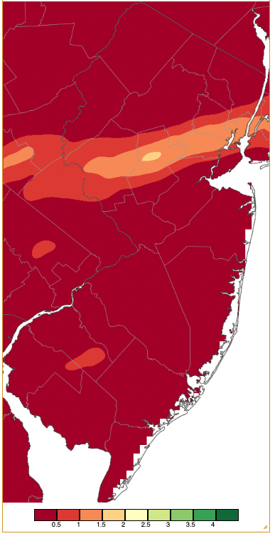
Figure 4. Precipitation across New Jersey from 8 AM on September 25th through 8 AM September 26th based on a PRISM (Oregon State University) analysis generated using generated using NWS Cooperative and CoCoRaHS observations. Note the scale in inches beneath the map.
The last weekly US Drought Monitor map of the month, released on the 29th, was valid through the early morning of the 27th (Figure 5). Compared to late August conditions, it showed improvements in the central NJ corridor that received beneficial rain on multiple occasions in September. Also, some improvement occurred in the northern Highlands and southeast. Conditions worsened somewhat along the northern coast. Almost the entire state ended September in some stage of drought or was considered abnormally dry, but not quite experiencing drought conditions.
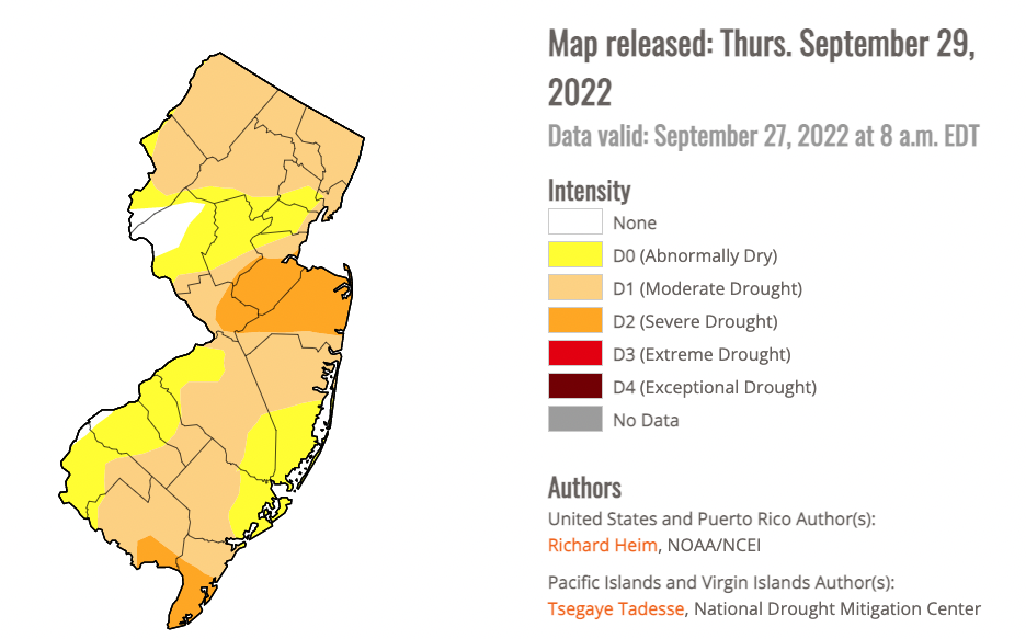
Figure 5. New Jersey portion of the U.S. Drought Monitor map for the last week of September.
Two days not reported above saw a NJWxNet station receive a 40 mph gust, including High Point Monument on the 15th and Harvey Cedars on the 30th. The lowest barometric pressures of the month were between 29.55”–29.65” on the 22nd. The highest from 30.35”–30.45” on the 29th.
Temperature
Twelve of the first 22 days of the month saw the temperature climb to 85° or higher, with three of them making it into the 90°s. Conversely, in addition to the 2nd, 15th, and 16th, the last eight days of the month saw lows dip to 45° or below at some locations. The month kicked off with 89° being reached at nine locations on the 1st, with 40 other NJWxNet stations topping out from 85°–89°. Piney Hollow (Gloucester) got to 88° on the 2nd, with West Deptford (Gloucester) also achieving this mark on the 3rd.
The 4th was the warmest September day. Hillsborough-Duke (Somerset) and Piney Hollow each reached 93°, 24 stations were from 90°–92°, and 31 others from 85°–89° (Figure 6). High Point Monument was coolest at 78°. The summer-like Labor Day weekend ended with 91° at Piney Hollow on the 5th, followed by 90° in Moorestown and Sicklerville (Camden), and 39 stations from 85°–89°. The Monument only made it to 71°.
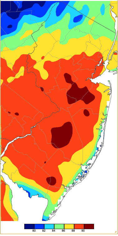
Figure 6. Maximum temperatures on September 4th based on a PRISM (Oregon State University) analysis generated using NWS, NJWxNet, and other professional weather stations. Note the 2-degree increment scale beneath the map.
Warmth resumed on the 10th, with Little Falls (Passaic) reaching 87°. Piney Hollow made it to 89° on the 12th, with 23 stations either 85° or 86°. Moorestown and Little Egg Harbor Township (Ocean) got to 87° and 86°, respectively, on the 13th. The 18th saw 15 locations at 85° or 86°. On the 19th, Berkeley Township (Ocean) hit 90°, likely the last time that mark will be reached in NJ in 2022. Some 44 stations made it from 85°–89° on the 19th. Hamilton (Mercer), Red Lion (Burlington), and Sicklerville reached 85° on the 21st.
The 22nd was the aforementioned seasonal transition day. Before the cold front made it to the coast, Point Pleasant (Ocean) reached 86°. By noon, the front was moving into central Jersey with temperatures already down into the mid 50°s in the northwest while the low 80°s prevailed near the coast (Figure 7). Temperatures fell 15° in about 30 minutes and up to 30° by late afternoon, as seen in the time series at Berkeley Township (Figure 8). The initial decline did not lower the dewpoint, but the second push brought in drier air as dewpoints quickly fell over 10°. Winds peaked with the initial frontal passage, gusting close to 30 mph at Berkeley Township and elsewhere.
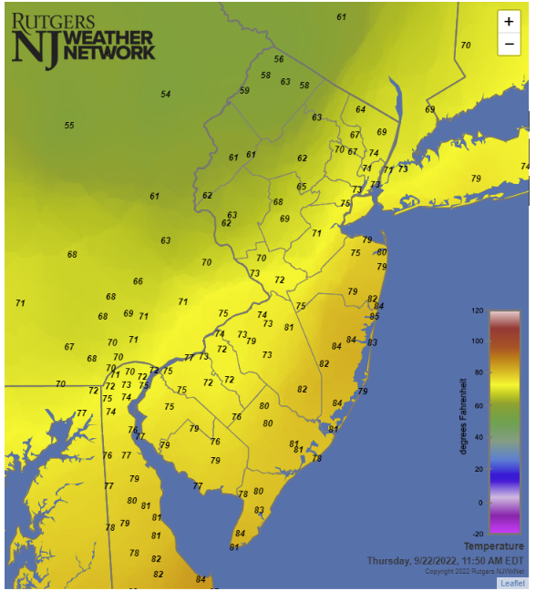
Figure 7. Surface air temperature at 11:50 AM EDT on September 22nd. Observations are from Rutgers NJ Weather Network, National Weather Service airport stations, Shrewsbury Weather Network, and Delaware Environmental Observing System Network.
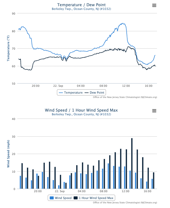
Figure 8. Time series of temperature and dew point (top) and wind (bottom) at the Berkeley Township NJWxNet stations from 5:00 PM on September 21st to 5:00 PM on September 22nd.
The daily high temperatures for the remainder of September stayed mainly in the 60°s and 70°s. Further demonstrating the flipping of the seasonal transition switch, the average daily high temperature at Hopewell Township over the first 21 days of September was 81.7° while the eight days after the 22nd had an average high of just 69.3°.
There were 11 September days where the low temperature at one or more NJWxNet station fell to 45° or lower. Not surprisingly, only three of these days were before the 22nd, while each day from the 23rd–30th reached that mark. The 2nd found Walpack (Sussex) down to 41°, and its often cold-air-drainage partners Sandyston (Sussex) at 43° and Pequest (Warren) 45°. The next 45° day was the 15th when Sandyston and Walpack each bottomed out at 44°. Sandyston was 38° on the 16th with 18 stations from 40°–45°.
The late-month run of sub-45° lows began with 39° at both Walpack and Stewartsville (Warren) on the 23rd. The 24th was the coldest day of September, with Walpack down to 33°, 19 stations from 35°–39°, and 33 at 40°–45° (Figure 9). Frost was found in the coldest areas and fog formed over still mild water bodies. Meanwhile, Lower Alloways Creek Township and West Cape May (Cape May) only fell to 52°.
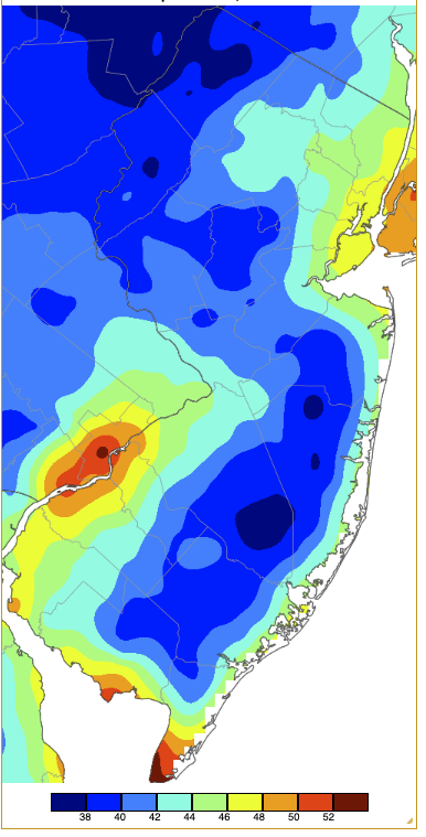
Figure 9. Minimum temperatures on September 24th based on a PRISM (Oregon State University) analysis generated using NWS, NJWxNet, and other professional weather stations. Note the 2-degree increment scale beneath the map.
Walpack, Pequest, and Sandyston were all at 44° on the 25th, Walpack was 44° on the 26th, and Walpack and Sandyston each 40° on the 27th. The 28th saw lows of 36° at Sandyston, Walpack 38°, Hopewell Township 39°, and 29 stations from 40°–45°. Walpack dropped to 36° on the 29th, with Pequest and Stewartsville at 39°. The 30th saw a large range in minimums from 36° at Walpack to 63° in Point Pleasant (Figure 10). The influence of mild coastal waters on lows was evident on this day when the coldest air was mainly found in northwest valleys.
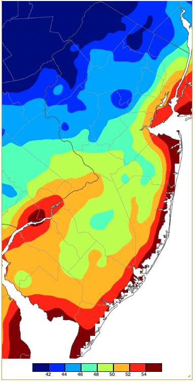
Figure 10. Minimum temperatures on September 30th based on a PRISM (Oregon State University) analysis generated using NWS, NJWxNet, and other professional weather stations. Note the 2-degree increment scale beneath the map.
For those seeking more detailed information on 5-minute, hourly, daily, and monthly conditions, please visit the following Office of the NJ State Climatologist's websites:
Rutgers NJ Weather Network
NJ Community Collaborative Rain, Hail and Snow Network
NJ Snow Event Reports
Interested in receiving our monthly summaries at the end of each month? Send us your e-mail address here to join the mailing list.
Past News Stories

