A Mixed Bag, and A Blow Torch Year: December & Annual 2020 Recaps
New Jersey State Climatologist
Center for Environmental Prediction, School of Environmental and Biological Sciences/NJAES, Rutgers University
January 6, 2021
December Overview
The statewide average temperature during this last month of 2020 averaged 37.0°. This was 1.8° above the 1981–2010 normal and ranks as the 22nd mildest December in the 126-year record that dates back to 1895. Northern and southern portions of NJ had similar departures and rankings.
December precipitation (rain and the liquid equivalent of snow and sleet) averaged 6.24” based on a statewide estimate generated by the PRISM Climate Group (Oregon State University; final divisional/statewide precipitation estimates from NOAA’s nClimDiv dataset were not yet available at the time of publication). This includes rain measured at National Weather Service Cooperative Observing stations on the morning of December 1st but does not include rain measured at these stations for the 24 hours ending on the morning of January 1st. See an explanation of the November 30th–December 1st measurement in the November report. The monthly value is 2.39” above average and ranks as the 11th highest December precipitation total on record. North Jersey averaged 6.73”, which is 2.78” above average and ranks 7th wettest. The south came in at 5.89”, which is 2.10” above average and ranks 17th wettest. The coast averaged 6.43”, which is 2.67” above average and ranks 11th wettest.
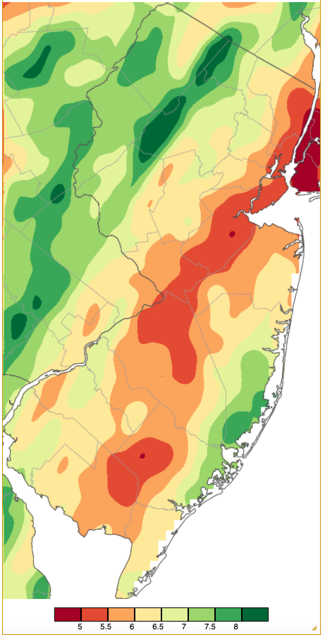
Figure 1. December 2020 precipitation across New Jersey based on a PRISM (Oregon State University) analysis generated using NWS Cooperative and CoCoRaHS observations from 7 AM on November 30th to 7 AM on December 31st. Totals range from 4.50”–4.99” (red) to 8.00”–8.49” (dark green).
December snowfall averaged 5.1” statewide. This is 0.8” above average and ranks as the 51st snowiest December since 1895. Northern counties averaged 10.6”, which is 4.5” above average, the central region 6.5” (+1.7”), and southern counties 1.4” (-1.7”).
Precipitation and Storms
Monthly precipitation (rain and melted snow) at NJ CoCoRaHS and NJWxNet stations was as high as 9.12” in Vernon Township (Sussex County). On the low end, Hamilton (Mercer) only saw 4.88”, though that is well above the normal December total for NJ. This includes rain measured at CoCoRaHS stations on the morning of December 1st but not for the 24 hours ending on the morning of January 1st. Other top totals include Jefferson Township (Morris) 8.63”, Hardyston (Sussex) 8.47”, Roxbury Township (Morris) 8.32”, Mount Arlington (Morris) 8.29”, Clinton (Hunterdon) 8.26”, and two West Milford (Passaic) stations at 8.24” and 8.13”. On the low side, Burlington (Burlington) saw 4.94”, Woodbury (Gloucester) 4.96”, Medford Lakes (Burlington) 4.97”, South River (Middlesex) 4.99”, and Highland Park (Middlesex) and Metuchen (Middlesex) each with 5.07”.
On the snow side, monthly totals were as high as 16.2” at both Highland Lakes (Sussex) and Holland Township (Hunterdon). Next up was Hardyston at 15.1”, both Wantage (Sussex) and Montague (Sussex) 13.8”, Bethlehem Township (Hunterdon) 13.4”, and Jefferson Township 13.2”.
The storm of November 30th to early December 1st was discussed in the November summary, including a listing of total rainfall that was topped by 3.77” in Califon (Morris) and 3.69” in Jefferson Township.
Up next was a rain event from later morning on the 4th until midday on the 5th. Heaviest totals were found in the far south with four Lower Township (Cape May) stations measuring 1.94”–2.20”, Wildwood Crest (Cape May) 2.12”, and three Middle Township (Cape May) sites from 1.58”–1.85” (Figure 2). Of 254 CoCoRaHS observations, 108 ranged from 1.00”–1.99”. Lowest totals were under 0.50” in the northwest.
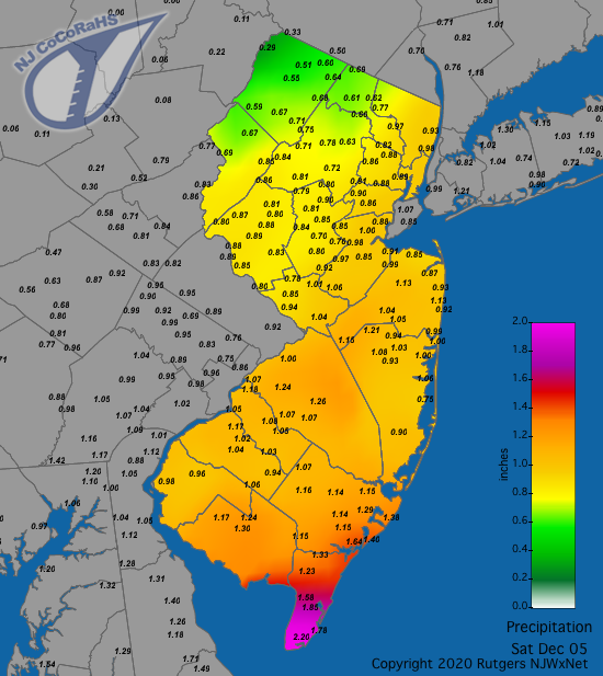
Figure 2. Rainfall from approximately 7 AM on December 4th to 7 AM on December 5th. Reports are from CoCoRaHS observers.
A light snowfall event occurred in northwest counties during the mid-day and afternoon hours of the 9th. Five counties saw 1.0”–2.0” at some locations, led by Knowlton Township (Warren) with 2.0”. Inch-plus totals were also found in Hunterdon, Morris, Somerset, and Sussex counties. At most, 0.16” of liquid was found in this snow at both Washington Township (Morris) and Frelinghuysen Township (Warren). Some locations in central and northern NJ saw their first measurable snowfall since January 18th.
The morning and afternoon of the 14th light to moderate rain across NJ, which ended as light snow in some central and northern locations. Rainfall totaled as much as 0.70” in Pennsville (Salem) and 0.69” at both Linwood and Woodbine (Cape May). Spots in four counties saw 1.0”-2.0” of snow, including Sparta (Sussex) 2.0”, Holland Township 1.9”, Greenwich (Warren) 1.4”, and Mine Hill (Morris) 1.0”.
The first of two major events in December occurred from the afternoon of the 16th to midday on the 17th. Rainfall was heavy in coastal counties while snowfall was heavy in the northwest. In between, light to moderate snow with some freezing rain occurred in the southwest, moderate snow and sleet in central NJ, and moderate to heavy snow with some sleet in the northeast. Strong winds accompanied the precipitation and minor to moderate flooding occurred along the coast. Rain and melted frozen precipitation amounted to as much as 3.28” in Linwood, 3.21” and 2.50” at two Stafford Township (Ocean) stations, Wildwood Crest 2.90”, Brigantine (Atlantic) 2.86”, and Galloway (Atlantic) 2.70”. There were 21 of the 234 CoCoRaHS reports from 2.00”–2.57” and 137 from 1.00”–1.99” (Figure 3).
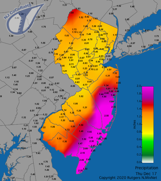
Figure 3. Rainfall and liquid equivalent of snow and sleet from approximately 7 AM on December 16th to 7 AM on December 17th. Reports are from CoCoRaHS observers.
Snowfall was measured in 20 counties, with only Cape May County missing out (Figure 4). There was not a report reaching an inch in Atlantic County, while 16 counties had one of more locations exceed 5.0”. Of the seven counties catching 10” or more, Highland Lakes came out the winner with 14.8” (Table 1).
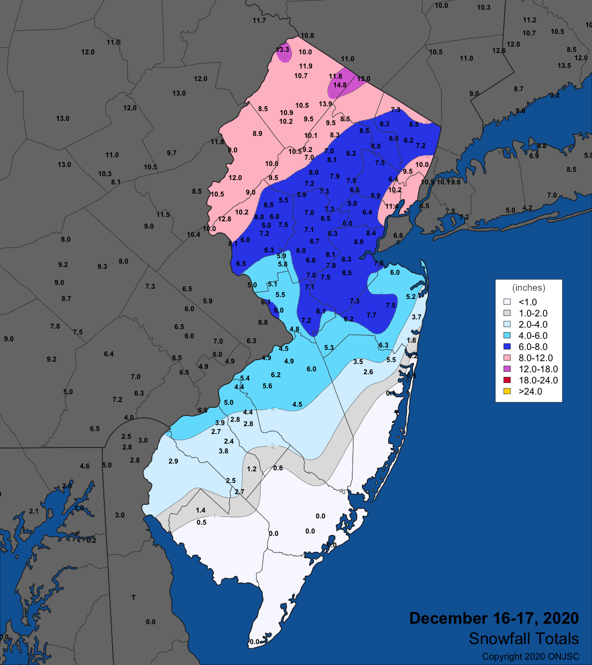
Figure 4. Snowfall from mid-day on December 16th through the morning of December 17th. Observations are from CoCoRaHS, NWS Cooperative Observer, and NWS Spotter reports.
| County | Location | Snowfall |
|---|---|---|
| Bergen | Palisades Park | 10.0” |
| Essex | Newark Airport | 11.4” |
| Hudson | Kearny | 10.5” |
| Hunterdon | Holland Twp. | 12.8” |
| Morris | Green Pond | 11.0” |
| Sussex | Highland Lakes | 14.8” |
| Warren | White Twp. | 12.0” |
Table 1. Largest snowfall in the seven NJ counties where totals on December 16th–17th equaled or exceeded 10.0”.
Wind gusts exceeded 50 mph on the 16th and 17th. On the first day, Sea Girt (Monmouth) saw a 59 mph gust, Atlantic City Marina (Atlantic) 52 mph, Point Pleasant (Ocean) 50 mph, and nine NJWxNet stations from 40–49 mph. Berkeley Township (Ocean) peaked at 52 mph on the 17th followed by Sea Girt at 51 mph, and 11 stations from 40–49 mph. Coastal flooding reached the moderate stage at Sandy Hook (Monmouth; Figure 5), with docks, roadways, and yards flooded at high tide on the morning of the 17th (Figure 6).
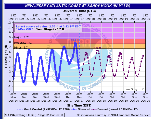
Figure 5. Tidal heights measured (blue line) and predicted (red line) at the Sandy Hook USGS gauge from 2PM on December 14th to 2 PM on December 20th.
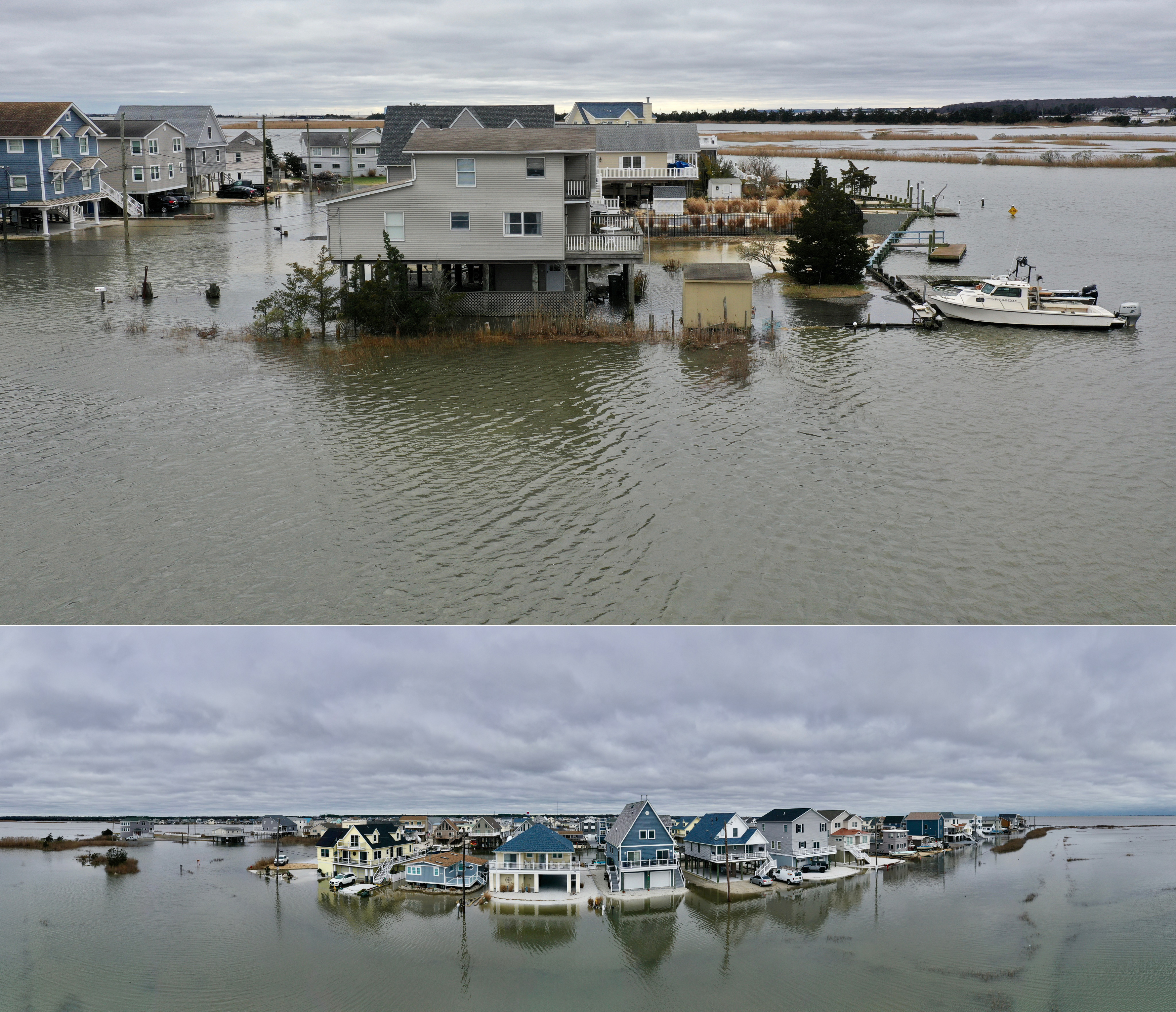
Figure 6. Drone photos of tidal flooding in the vicinity of Tuckerton (Ocean) near the morning high tide on December 17th. Photos courtesy of Life on the Edge Drones.
The second major storm of the month was a mild rainy event commencing in the afternoon of the 24th and ending by late Christmas morning. Strong southerly winds boosted temperatures into the 50°s and 60°s during the storm, which melted all of the snowpack remaining from the 16th–17th storm. This, along with heavy rainfall, led to minor and locally moderate flooding on some streams and rivers. Rainfall totaled as much as 2.76” in Mt. Olive (Morris), 2.62”and 2.69” at two Rockaway Township (Morris) stations, Vernon Township 2.66”, Washington Township (Morris) 2.65”, Newton (Sussex) 2.60”, and West Milford 2.58”. Some 41 CoCoRaHS stations caught 2.00”–2.45”, and 147 from 1.00”–1.99” (Figure 7). Cape May County saw the lowest amounts with only 0.53” falling at stations in Lower and Middle townships. The stream gauge record from Blackwells Mills (Somerset) on the Millstone River exemplifies the rapid increase of water flowing down New Jersey’s streams and rivers as a result of the rain and melted snow (Figure 8). The water level rose 6.5 feet and the amount of water flowing past the gauging station increased eight fold in 36 hours.
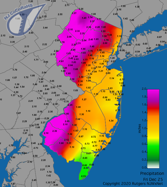
Figure 7. Rainfall from approximately 7 AM on December 24th to 7 AM on December 25th. Reports are from CoCoRaHS observers.
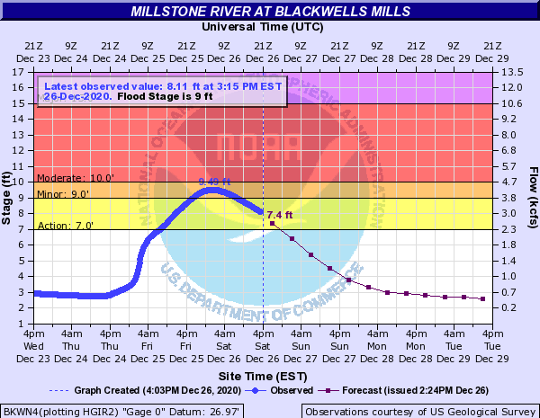
Figure 8. USGS stream gauge on the Millstone River at Blackwells Mills at 4PM on the 26th. The blue line shows stage height from 4PM on the 23rd to observation time. The red line shows projected heights until 4PM on the 29th.
Storm winds invaded south Jersey during the evening of the 24th, gusting to 58 mph at both Fortescue (Cumberland) and Upper Deerfield (Cumberland), 57 mph at Lower Alloways Creek Township (Salem) and Logan Township (Gloucester), 50–53 mph at six other locations, and 40–49 mph at 20 other NJWxNet sites. The howling winds spread northward early on the 25th, with statewide gusts of 69 mph at Mannington (Salem), Teterboro (Bergen) 67 mph, Sandy Hook 66 mph, Lakehurst (Burlington) 63 mph, Sea Girt 62 mph, Vernon Township, Perth Amboy (Middlesex) and Berkeley Township all 60 mph, 50–59 mph at sight NJWxNet locations, and 40–49 mph at 26 more sites. Trees and power lines fell, resulting in 100,000 customers losing power.
Once again, a rain event occurred on the last day of the month. While not nearly as large as the event on November 30 into early December 1, this one occurred surrounding observation times at most locations. Thus for some stations, the bulk of the rain was recorded as December 31st, while for others it is in the books for January 1st. Being mainly a central Jersey event, the most that fell was 0.75” in Franklin Township (Somerset), followed by 0.71” in both Manville (Somerset) and Metuchen.
In addition to the wind gusts exceeding 40 mph in the storms of the 16th–17th and 24th–25th, such gusts were observed at one or more NJWxNet station on an impressive 11 other December days. Lower Alloways Creek Township reached 41 mph on the 1st and Point Pleasant 42 mph on the 2nd. The 5th found High Point Monument (HPM) and Vernon Township each at 46 mph and Fortescue and Lower Alloways Creek Township both at 41 mph. HPM reached 56 mph and Vernon Township 43 mph on the 6th, with HPM at 44 mph on the 7th and 42 mph on the 8th. HPM hit 51 mph on the 14th and Vernon Township 40 mph. Gusts to 47 mph occurred at HPM on the 22nd and up to 40 mph at Vernon Township on the 23rd. Lower Alloways Creek Township gusted to 42 mph and HPM 41 mph on the 29th, and Vernon Township to 40 mph on the 31st. It is worth noting that logistical issues have kept winds from being recorded at often windy Harvey Cedars (Ocean) and Seaside Heights (Ocean) this month.
The highest barometric pressure this month was on the 19th and 23rd, sitting from 30.40”–30.45”. The 25th brought the lowest pressure of 29.35”–29.45”.
Temperature
The thermometer see-sawed throughout December. When all was said and done, daily maximum temperatures reached 55° or higher on 10 days at one or more of the 63 NJWxNet stations, with no run longer than 3 days. Minimums fell to 20° or lower on 17 days at one or more sites, with two runs as long as six days.
On the mild side, Howell (Monmouth) topped out at 59° and four other stations at 58° on the 1st. Five stations reached 55° on the 3rd, with West Cape May (Cape May) at 57° and Atlantic City Marina and Cape May Court House (Cape May) 56° on the 4th. Five locations hit 60°, 19 sites 59°, and 22 from 55°–58° on the 11th. Six stations made it to 64° on the 12th, along with 24 from 60°–63°, and 11 from 55°–59°, while Walpack (Sussex) only reached 44°. Milder still was the 13th, with West Creek (Ocean) up to 67°, 11 stations at 66°, and 37 from 60°–65°.
The storm on the 16th resulted in a huge disparity between temperatures in northern and southern NJ. The maximum reached 51° in West Cape May but only 18° at HPM. Minimums ranged from 31° at Sea Girt to 13° at HPM. Figure 9 shows the wide range late in the evening that day.
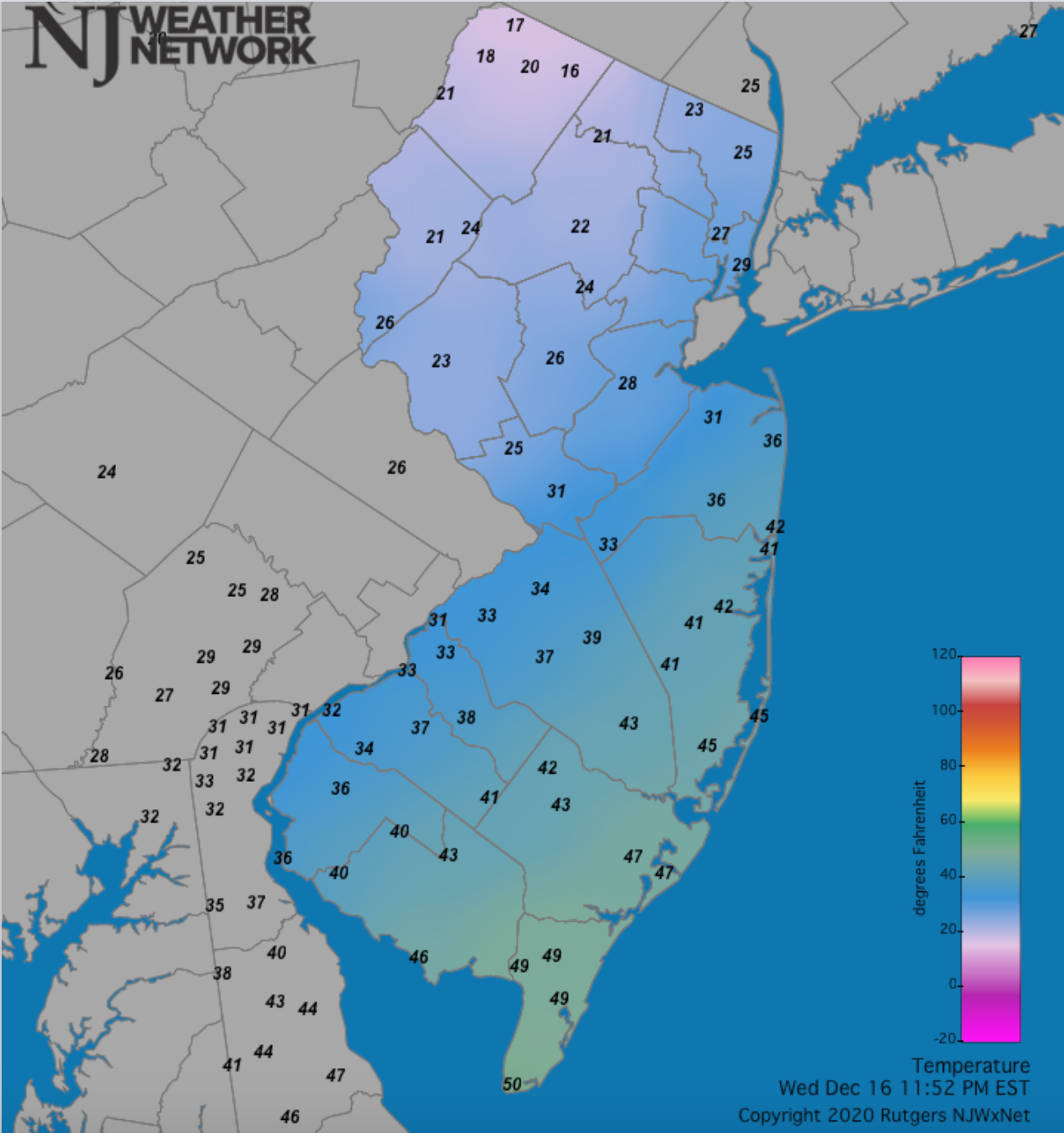
Figure 9. Temperature on December 16th at 11:52 PM showing NJ observations ranging from 50° in West Cape May to 16° in Vernon Township (reading of 14° at High Point Monument not shown). Reports are from the Rutgers NJ Weather Network, the Delaware Environmental Observation System, and NWS stations.
The storm on the 24th–25th saw temperatures rise to 65° at Mannington, 64° at seven stations, and 60°–63° at 35 others on day one. In the early hours of the 25th, West Deptford (Gloucester) peaked at 67°, four locations at 66°, and 50 others from 60°–65°. Southerly winds blowing off Delaware Bay kept both the Fortescue and Lower Alloways Creek Township stations at a somewhat cooler maximum of 56°. The 28th saw the temperature rise to 55° at both West Creek and Cape May Court House. These two stations saw, respectively, 56° and 55° on the 31st, with Woodbine also coming in at 55°.
Minimums fell to the upper teens on at least one day from the 7th to 9th at Pequest (Warren), Walpack, Hopewell Township (Mercer), and Berkeley Township. Walpack reached 19° on the 11th. The 15th–20th was the coldest stretch of the month. It began with HPM at 17° and three stations 18°–19°. The 16th found HPM down to 13° and eight locations from 14°–19°. Kingwood (Hunterdon) and Pequest fell to 13° on the 17th, with HPM and Hillsborough-Duke (Somerset) each at 14° and 11 sites 15°–19°. With fresh snow cover and clear skies, Walpack reached 6°, Pequest 7°, Sandyston (Sussex) 8°, and 22 locations from 11°–19° on the 18th. Colder still was the 19th when Walpack bottomed out at -5° and Pequest -1°, the first sub-zero readings of the season. Sandyston fell to 0°, Hopewell Township 2°, Kingwood 3°, seven locations from 5°–9°, and 36 from 10°–20°. West Cape May was “mildest” at 25°. Conditions moderated a bit on the 20th, with Walpack at 17°, and Hopewell Township and Sandyston each 18°.
Just before the brief storm warm up, Walpack fell to 20° on the 23rd. Behind the storm, cold air began to pour into NJ, particularly at the highest elevations where late on the 25th saw daily minimums of 19° at HPM and 20° at both High Point (Sussex) and Vernon Township. Temperatures dropped further on the 26th, with HPM at 13° and both High Point and Sandyston at 15°. The 27th found these three locations at 14°, with 34 other NJWxNet station from 15°–20°. Hopewell dropped to 20° on the 28th, Berkeley Township to 17° on the 29th, and these two stations each to 16° on the 30th.
Annual Overview
The statewide annual temperature of 55.5° was 2.6° above the 1981–2010 average and ranked second warmest since 1895 (Table 2). The first two decades of this century have included 15 of the 21 warmest years, with eight within the past ten years. The 2020 average was 3.7° above the average from 1895–2020. The average maximum of 65.2° was 2.2° above average (1981–2010), ranking 3rd warmest. The average minimum of 45.8° was 3.0° above average, ranking 2nd warmest. All regions of NJ ranked second warmest.
| Rank | Year | Annual Avg. Temp. |
|---|---|---|
| 1 | 2012 | 55.9° |
| 2 | 2020 | 55.5° |
| 3 | 1998 | 55.2° |
| 4 | 2016 | 55.0° |
| 4 | 2006 | 55.0° |
| 6 | 2011 | 54.9° |
| 7 | 2010 | 54.7° |
| 8 | 2017 | 54.6° |
| 9 | 1990 | 54.5° |
| 10 | 1991 | 54.4° |
| 11 | 2019 | 54.3° |
| 11 | 2002 | 54.3° |
| 13 | 2018 | 54.2° |
| 14 | 1999 | 54.1° |
| 15 | 2015 | 53.9° |
| 15 | 1949 | 53.9° |
| 17 | 2008 | 53.6° |
| 17 | 2007 | 53.6° |
| 17 | 2001 | 53.6° |
| 20 | 2005 | 53.5° |
| 20 | 1953 | 53.5° |
Table 2. The 21 warmest years across New Jersey since 1895.
Annual precipitation averaged 50.96”, which is 4.60” above normal and ranks 27th wettest. The southern portion of NJ (Middlesex to Mercer and all counties south of there, excepting coastal areas east of the Garden State Parkway) averaged 53.12” for 2020. This was 8.07” above average and ranks as the 14th wettest on record. Looking more closely within that region, the southeast and southwest areas were by far the wettest, leaving northern reaches quite a bit drier (Figure 10). Meanwhile, the north, usually wetter than the south, was drier, averaging 47.35”. This was 1.28” below average and ranks as the 71st driest/56th wettest year out of the past 126. The coast averaged 53.52”, which is 9.33” above average and ranks 12th wettest.
The wettest stations in the NJ CoCoRaHS network included three locations in Woodbine (Cape May) with 64.10”, 59.75”, and 57.50”, Franklin Township (Gloucester) 62.52”, Brigantine (Atlantic) 62.55”, Galloway (Atlantic) 62.41”, Woodstown (Salem) 62.39”, Hamilton (Atlantic) 60.90”, Egg Harbor Township (Atlantic) 60.76”, South Harrison (Gloucester) 60.29”, and Pittsgrove (Salem) 60.03”. The driest locations included Hamilton (Mercer) 42.65”, Andover (Sussex) 42.69”, Glen Rock (Bergen) 43.71”, Blairstown (Warren) 44.96”, and Montague (Sussex) 45.16”.
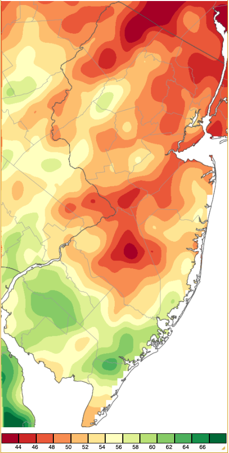
Figure 10. Annual 2020 precipitation across New Jersey based on a PRISM (Oregon State University) analysis generated using NWS Cooperative and CoCoRaHS observations. NJ totals ranged from 42”–44” (red) to 66”–68” (dark green). Note that values in Delaware were higher, with no area in NJ greater than between 62”–64”.
For those seeking more detailed information on 5-minute, hourly, daily, and monthly conditions, please visit the following Office of the NJ State Climatologist's websites:
Rutgers NJ Weather Network
NJ Community Collaborative Rain, Hail and Snow Network
NJ Snow Event Reports
Interested in receiving our monthly summaries at the end of each month? Send us your e-mail address here to join the mailing list.
Past News Stories

