

Post Tropical Storm Sandy Event Overview
The tables and maps below include peak storm wind gust and storm total-rainfall reports gathered from a variety of sources, including National Weather Service, CoCoRaHS, and NJ Weather and Climate Network stations. Reports were evaluated by the ONJSC and only those that appear to be reasonable and in line with the general wind and rainfall patterns of the storm have been included.
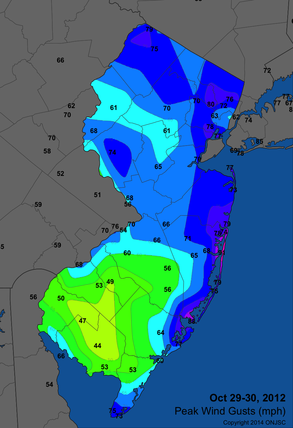
Sandy Wind Gusts
|
County |
Station |
Peak Wind Gust |
|
Atlantic |
Absecon |
66 |
|
Atlantic City Airport |
64 |
|
|
Atlantic City Marina |
77 |
|
|
Bergen |
Haworth |
56 |
|
North Arlington |
63 |
|
|
Teaneck |
76 |
|
|
Teterboro |
72 |
|
|
Burlington |
Burlington NOS |
54 |
|
Florence |
70 |
|
|
McGuire AFB |
66 |
|
|
Mount Holly Airport |
60 |
|
|
Oswego Lake |
56 |
|
|
Woodland Twp |
56 |
|
|
Camden |
Sicklerville |
49 |
|
Cumberland |
Bivalve |
53 |
|
Millville Airport |
44 |
|
|
Upper Deerfield |
47 |
|
|
Cape May |
Cape May |
73 |
|
Cape May NOS Buoy |
75 |
|
|
Ocean City |
60 |
|
|
Woodbine |
53 |
|
|
Essex |
Caldwell Airport |
70 |
|
Newark Airport |
78 |
|
|
Gloucester |
Washington Twp |
53 |
|
Hudson |
Bayonne |
77 |
|
Harrison |
68 |
|
|
Hunterdon |
Pittstown |
74 |
|
Mercer |
Trenton Airport |
68 |
|
Middlesex |
Perth Amboy |
70 |
|
Monmouth |
Cream Ridge |
66 |
|
Monmouth Beach |
73 |
|
|
Sandy Hook NOS Buoy |
77 |
|
|
Sea Girt |
79 |
|
|
Morris |
Parsippany |
70 |
|
Ocean |
Barnegat Light |
79 |
|
Berkeley Twp |
65 |
|
|
Brick Twp |
78 |
|
|
Harvey Cedars |
75# |
|
|
Lakehurst NAS |
71 |
|
|
Point Pleasant |
74 |
|
|
Seaside Heights |
91* |
|
|
Toms River |
68 |
|
|
Tuckerton |
88 |
|
|
Passaic |
Clifton |
80 |
|
Salem |
Woodstown |
50 |
|
Somerset |
Basking Ridge |
61 |
|
Hillsborough |
65 |
|
|
Sussex |
High Point Monument |
79 |
|
Sussex Airport |
75 |
|
|
Wantage |
69 |
|
|
Warren |
Pequest |
61 |
|
Stewartsville |
68 |
# The anemometer mast at Harvey Cedars was blown over during the storm. Therefore, wind gusts exceeding the maximum listed value of 75 mph may have occurred.
* A post-storm examination of the wind observations at Seaside Heights resulted in the recognition of an incorrect setting in the station's data logger that resulted in consistent under reporting of wind speeds beginning with the installation of a new anemometer two weeks before Sandy. An adjustment factor has been applied to the storm maximum wind speed recorded at this station, resulting in an upgrade of the maximum gust from 71 mph to 91 mph.
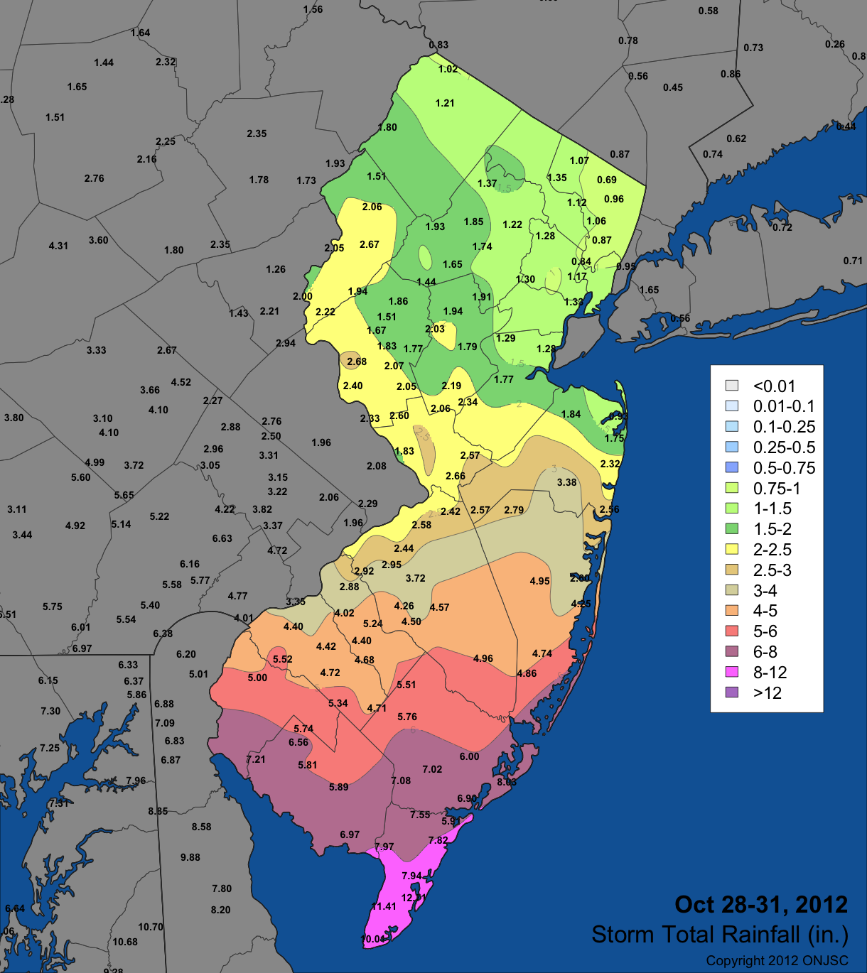
Sandy Storm-Total Rainfall
|
County |
Station |
Rainfall Total |
|
Atlantic |
Atlantic City Airport |
6.00 |
|
Atlantic City Marina |
8.03 |
|
|
Buena Vista Twp |
5.75 |
|
|
Egg Harbor Twp |
6.11-6.97 |
|
|
Estell Manor |
6.32-7.08 |
|
|
Folsom |
5.76 |
|
|
Hammonton |
5.13-5.51 |
|
|
Hammonton |
5.13 |
|
|
Linwood |
6.90 |
|
|
Bergen |
Haworth |
0.88 |
|
New Milford |
0.96 |
|
|
North Arlington |
0.84 |
|
|
Oakland |
0.75-1.35 |
|
|
Palisades Park |
0.91 |
|
|
Ramsey |
1.07 |
|
|
Saddle Brook Twp |
1.06 |
|
|
Teterboro Airport |
0.87 |
|
|
Woodcliff Lake |
0.69 |
|
|
Burlington |
Chesterfield Twp |
2.42 |
|
Hainesport Twp |
2.52 |
|
|
Indian Mills |
4.50 |
|
|
Mansfield |
2.58 |
|
|
Medford Lakes |
3.23-4.26 |
|
|
Medford Twp |
4.10 |
|
|
Millville Airport |
5.89 |
|
|
Moorestown Twp |
2.83-3.16 |
|
|
Mount Holly |
2.44 |
|
|
Mount Laurel Twp |
2.95 |
|
|
Oswego Lake |
4.96 |
|
|
Seabrook Farms |
6.56 |
|
|
Southampton Twp |
3.72 |
|
|
Tabernacle Twp |
3.05-4.57 |
|
|
Cumberland |
Bivalve |
6.97 |
|
Bridgeton |
6.17 |
|
|
Fairfield Twp |
5.81 |
|
|
Greenwich |
7.21 |
|
|
Greenwich Twp |
6.40 |
|
|
Upper Deerfield Twp |
5.74-6.39 |
|
|
Cape May |
Cape May |
10.01 |
|
Cape May Courthouse |
7.94 |
|
|
Dennis Twp |
7.97 |
|
|
Middle Twp |
11.41 |
|
|
Stone Harbor |
12.71 |
|
|
Upper Twp |
5.91-7.82 |
|
|
West Cape May |
9.53 |
|
|
Wildwood Crest |
11.70 |
|
|
Woodbine |
7.41-7.87 |
|
|
Camden |
Berlin Twp |
3.78-5.24 |
|
Cherry Hill |
2.88 |
|
|
Merchantville |
2.37 |
|
|
Mount Ephraim |
3.91 |
|
|
Sicklerville |
4.40 |
|
|
Somerdale |
4.02 |
|
|
Stratford |
3.97 |
|
|
Winslow Twp |
4.68 |
|
|
Essex |
Canoe Brook |
1.30 |
|
Maplewood |
0.80 |
|
|
Montclair |
1.11 |
|
|
Newark Airport |
1.33 |
|
|
West Caldwell Twp |
1.28 |
|
|
Gloucester |
Bethel Mill Park |
4.42 |
|
Clayton |
4.72 |
|
|
East Greenwich Twp |
3.39-4.40 |
|
|
Elk Twp |
4.57 |
|
|
Franklin Twp |
5.34 |
|
|
Monroe Twp |
4.52 |
|
|
Piney Hollow |
4.71 |
|
|
South Harrison |
5.52 |
|
|
Washington Twp |
5.01 |
|
|
Woolwich Twp |
4.84 |
|
|
Hudson |
Harrison |
1.17 |
|
Hunterdon |
Clinton Twp |
1.51-1.73 |
|
Flemington |
1.77-2.07 |
|
|
Franklin Twp |
1.67 |
|
|
Holland Twp |
2.02 |
|
|
Kingwood |
2.68 |
|
|
Lambertville |
2.33 |
|
|
Lebanon |
1.86 |
|
|
Pittstown |
2.47 |
|
|
Readington Twp |
1.80 |
|
|
Stockton |
2.40 |
|
|
Wertsville |
2.05 |
|
|
Mercer |
Hamilton Twp |
2.05-2.18 |
|
Hightstown |
2.57 |
|
|
Hopewell Twp |
2.60 |
|
|
Lawrence Twp |
2.84 |
|
|
Trenton Mercer County Airport |
1.83 |
|
|
Washington Twp |
2.66 |
|
|
Middlesex |
New Brunswick |
1.33-1.77 |
|
North Brunswick Twp |
1.68 |
|
|
South Brunswick Twp |
2.34 |
|
|
South Plainfield |
1.20-1.29 |
|
|
Woodbridge Twp |
1.28 |
|
|
Monmouth |
Asbury Park |
2.16 |
|
Cream Ridge |
2.57 |
|
|
Eatontown |
1.52 |
|
|
Holmdel |
1.84 |
|
|
Howell Twp |
3.34-3.38 |
|
|
Long Branch |
1.65 |
|
|
Ocean Twp |
2.32 |
|
|
Oceanport |
1.75 |
|
|
Rumson |
0.93 |
|
|
Sea Girt |
2.56 |
|
|
Wall Twp |
2.44 |
|
|
Morris |
Boonton Twp |
1.09-1.22 |
|
Chatham |
1.12-1.59 |
|
|
Dover |
1.85 |
|
|
Long Hill Twp |
1.70 |
|
|
Mendham Twp |
1.43-1.65 |
|
|
Mine Hill Twp |
1.80 |
|
|
Morris Twp |
1.04 |
|
|
Mount Olive Twp |
1.38 |
|
|
Netcong |
1.93 |
|
|
Oak Ridge Reservoir |
1.37 |
|
|
Parsippany |
1.74 |
|
|
Parsippany-Troy Hills Twp |
1.06 |
|
|
Pottersville |
1.44 |
|
|
Randolph Twp |
2.05 |
|
|
Ocean |
Berkeley Twp |
2.60-4.95 |
|
Jackson Twp |
2.79 |
|
|
Lacey Twp |
4.25 |
|
|
Little Egg Harbor Twp |
4.86 |
|
|
Point Pleasant Beach |
2.41 |
|
|
Stafford Twp |
4.74 |
|
|
Toms River |
3.60 |
|
|
Passaic |
Charlotteburg |
2.10 |
|
Hawthorne |
0.99-1.12 |
|
|
Wanaque |
1.26 |
|
|
Salem |
Pennsville Twp |
5.31 |
|
Pittsgrove Twp |
5.85 |
|
|
Woodstown |
4.96-5.00 |
|
|
Somerset |
Basking Ridge |
1.91 |
|
Bedminster Twp |
1.94 |
|
|
Bound Brook |
1.79 |
|
|
Branchburg Twp |
2.03 |
|
|
Bridgewater Twp |
1.84-2.81 |
|
|
Franklin Twp |
1.69-1.84 |
|
|
Hillsborough Twp |
1.45-2.15 |
|
|
Montgomery Twp |
2.06-2.19 |
|
|
Sussex |
Sussex |
1.21 |
|
Walpack |
1.80 |
|
|
Wantage Twp |
1.02-1.21 |
|
|
Warren |
Allamuchy Twp |
2.00 |
|
Belvidere Bridge |
2.05 |
|
|
Blairstown Twp |
1.51-2.06 |
|
|
Franklin Twp |
1.94 |
|
|
Greenwich Twp |
2.22 |
|
|
Mansfield Twp |
2.50 |
|
|
Oxford Twp |
2.46 |
|
|
Pequest |
2.67 |
|
|
Phillipsburg |
2.00 |
|
|
Riegelsville |
2.46 |
|
|
White Twp |
2.24 |
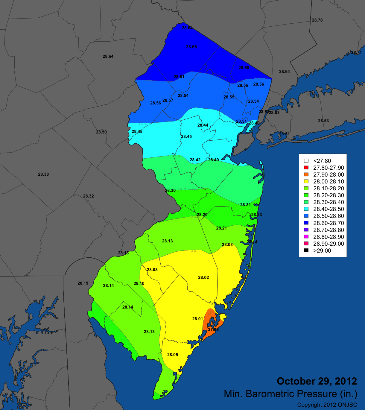
Sandy Minimum Barometric Pressure
For those seeking more detailed information on hourly, daily and monthly conditions, please visit the following Office of the NJ State Climatologist's websites:
NJ Weather and Climate Network
NJ Community Collaborative Rain, Hail and Snow Network
NJ Snow Event Reports
Interested in receiving our monthly summaries at the end of each month? Send us your e-mail address here to join the mailing list.
Past Climate Summaries