 Daily
Weekly
Monthly
Monthly Departure
Monthly Climatology
Documentation
Snow Anomalies
Monthly Anomalies
Seasonal Extent
Weekly
Monthly
Rankings
Download
Daily
Weekly
Monthly
Monthly Departure
Monthly Climatology
Documentation
Snow Anomalies
Monthly Anomalies
Seasonal Extent
Weekly
Monthly
Rankings
Download

This MEaSUREs project assesses compliance of current Northern Hemisphere snow cover products over land, sea ice and the
Greenland ice sheet with NRC Climate Data Record (Earth System Data Record) characteristics. Data records are blended
using statistical measures to develop enhanced ESDRs of NH snow and ice conditions. ESDRs and associated products will be made available
to the user community.
Through the MEaSUREs Program, NASA is continuing its commitment to expand understanding of the Earth system using consistent records. NASA has begun to deploy new types of sensors to provide three-dimensional profiles of Earth’s atmosphere and surface. Emphasis is placed on linking together multiple satellites into a constellation, developing the means to utilize a multitude of data sources to form coherent time series, and facilitating the use of extensive data in the development of comprehensive Earth system models.
Snow on Land
National Oceanic and Atmospheric Administration (NOAA) meteorologists began production of satellite-derived maps of Northern Hemisphere snow cover extent (SCE) in late 1966. Despite their proven climate utility, meteorological forecasting has been the driving force behind producing these maps. As such, changes (documented and undocumented) in mapping methodologies have occurred over time, without a focus on their climatological continuity.
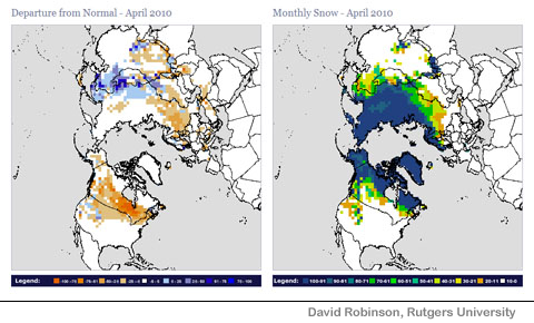
Members of our team have kept a watchful eye on changes in this satellite environmental data record (EDR). From this EDR, we have developed a satellite SCE climate data record (CDR). No other environmental variable has been mapped from satellite data in a generally consistent manner for such a long period. The visible satellite weekly snow extent CDR is useful in monitoring climate variability and change, and as input and validation for climate models.
The Moderate-Resolution Imaging Spectroradiometer (MODIS) snow and ice project develops maps of global snow and sea ice extent and ice-surface temperature. The MODIS cloud-gap-filled (CGF) snow algorithm provides a cloud-free daily snow map using a gap-filling technique. The removal of clouds from the daily MODIS snow-cover maps facilitates comparisons with the cloud-free Rutgers maps and IMS daily snow charts for the production of a CDR.
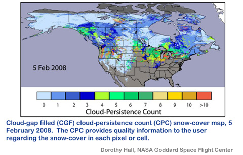
The CGF maps are also useful for hydrologic studies such as the development of snow cover depletion curves for snowmelt-runoff modeling and for streamflow prediction.
Satellite-derived maps of Greenland surface and near-surface melt from SSM/I and SMMR passive microwave data using a dynamic threshold algorithm have been generated. The spatial extent of melt, melt frequency and melt duration have been upgraded to Climate Data Record (CDR) quality. These products have been used to corroborate surface temperature records, select regions for ice core analysis, and interpret atmospheric reanalysis products.
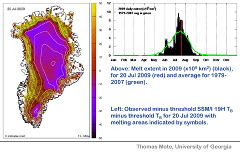
The Greenland maps provide a mature data record necessary for monitoring climate change at high latitudes, and improve our understanding of climate change on the surface mass balance of the Greenland ice sheet.
Snow on Sea Ice
Satellite-derived maps of melt onset dates from SMMR and SSM/I passive microwave data using a 10 day moving melt threshold algorithm. Melt onset dates through brightness temperature conversions have been upgraded to climate data record (CDR) quality.
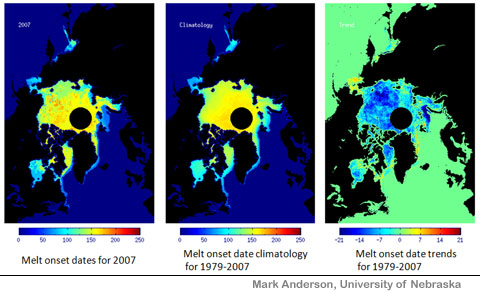
Melt onset dates mark the start of significant changes in surface albedo over Arctic Sea Ice. The use of such dates represent a valuable tool for monitoring climate variability and change, and as input and validation for climate models.
Satellite-derived estimates of Arctic sea ice age (from one to 10 years old) have been developed for 1979 to present. This product provides unique and direct evidence of fundamental changes in Arctic sea ice cover, and helps evaluate and improve sea ice and climate models.
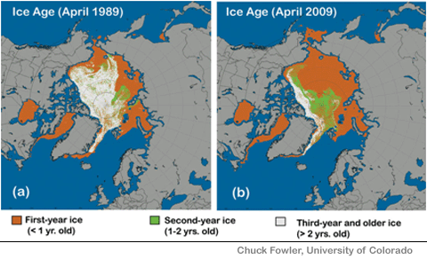
Besides contributing to a basic understanding of the Arctic climate system, sea ice age is relevant for analyses of sea ice trends, relationships to other parameters such as ice thickness and albedo, and model evaluation. Click for more information: [ Arctic Ice Age ]
Merging Land and Ocean Observations
Future ESDR products will integrate multiple elements including snow extent, ice concentration, melt atop ice, pressure, and temperature.
![]()